යුප්රටීස්
Appearance
| Euphrates | |
|---|---|
 | |
 Map of the combined Tigris–Euphrates drainage basin (in yellow) | |
| Etymology | from Greek, from Old Persian Ufrātu, from Elamite ú-ip-ra-tu-iš |
| පිහිටීම | |
| Country | Turkey, Iraq, Syria |
| Basin area | Turkey, Syria, Iraq, Saudi Arabia, Kuwait, Iran |
| Cities | Birecik, Raqqa, Deir ez-Zor, Mayadin, Haditha, Ramadi, Habbaniyah, Fallujah, Kufa, Samawah, Nasiriyah |
| භෞතික ලක්ෂණ | |
| ජල මූලාශ්රය | |
| - location | Murat Su, Turkey |
| - elevation | 3,520 m (11,550 ft) |
| 2nd source | |
| - location | Kara Su, Turkey |
| - elevation | 3,290 m (10,790 ft) |
| Source confluence | |
| - location | Keban, Turkey |
| - elevation | 610 m (2,000 ft) |
| ගං මෝය | Shatt al-Arab |
- ස්ථානය | Al-Qurnah, Basra Governorate, Iraq |
- ඛණ්ඩාංක | 31°0′18″N 47°26′31″E / 31.00500°N 47.44194°Eඛණ්ඩාංක: 31°0′18″N 47°26′31″E / 31.00500°N 47.44194°E |
| දිග | Approx. 2,800 km (1,700 mi) |
| Basin size | Approx. 500,000 km2 (190,000 sq mi) |
| Discharge | |
| - location | Hīt |
| - average | 356 m3/s (12,600 cu ft/s) |
| - minimum | 58 m3/s (2,000 cu ft/s) |
| - maximum | 2,514 m3/s (88,800 cu ft/s) |
| ද්රෝණියේ ලක්ෂණ | |
| River system | Tigris–Euphrates river system |
| අතු ගංගා | |
| - වම | Balikh, Khabur |
| - දකුණ | Sajur |
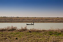
යුප්රටීස් (ඉංග්රීසි: Euphrates, ![]() i/juːˈfreɪtiːz/) යනු බටහිර ආසියාවේ දිගම සහ ඓතිහාසිකව වැදගත්ම ගංගාව වේ. "දෙගම්මැදි ශිෂ්ටාචාරය" (the "Land Between the Rivers") එනම් මෙසපොතේමියාව නම් කිරීමට හේතු වූයේ මෙම ගංගාව හා ටයිග්රීස් ගංගාවේ එකතුව වේ.
i/juːˈfreɪtiːz/) යනු බටහිර ආසියාවේ දිගම සහ ඓතිහාසිකව වැදගත්ම ගංගාව වේ. "දෙගම්මැදි ශිෂ්ටාචාරය" (the "Land Between the Rivers") එනම් මෙසපොතේමියාව නම් කිරීමට හේතු වූයේ මෙම ගංගාව හා ටයිග්රීස් ගංගාවේ එකතුව වේ.
ඉතිහාසය
[සංස්කරණය]
මෙම කොටස හිස්ය. එය පුළුල් කිරීමෙන් ඔබ හට උපකාර කළ හැක. |
මූලාශ්ර
[සංස්කරණය]භාහිර සබැඳි
[සංස්කරණය] Euphrates හා සබැඳි මාධ්ය විකිමාධ්ය කොමන්ස් හි ඇත


