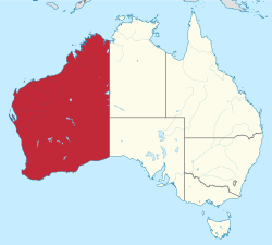
බටහිර ඕස්ට්රේලියාව
Appearance
(Western Australia වෙතින් යළි-යොමු කරන ලදි)
| Western Australia | |||||
|---|---|---|---|---|---|
| |||||
| Slogan or nickname | The Wildflower State; The Golden State | ||||
 Other Australian states and territories | |||||
| Coordinates | 26°S 121°E / 26°S 121°Eඛණ්ඩාංක: 26°S 121°E / 26°S 121°E | ||||
| Capital city | Perth | ||||
| Demonym | Western Australian, West Australian, Sandgroper (colloquial) | ||||
| Government | Constitutional monarchy | ||||
| • Governor | Kim Beazley | ||||
| • Premier | Mark McGowan (Labor) | ||||
| Australian state | |||||
| • Established (as the Swan River Colony) | 2 මැයි 1829 | ||||
| • Responsible government | 21 ඔක්තෝබර් 1890 | ||||
| • Federation | 1 ජනවාරි 1901 | ||||
| • Australia Act | 3 මාර්තු 1986 | ||||
| Area | |||||
| • Total | 2,645,615 km² (1st) 1,021,478 sq mi | ||||
| • Land | 2,529,875 km² 976,790 sq mi | ||||
| • Water | 115,740 km² (4.37%) 44,687 sq mi | ||||
| Population (December 2018)[1] | |||||
| • Population | 2,606,338 (4th) | ||||
| • Density | 1.03/km² (7th) 2.7 /sq mi | ||||
| Elevation | |||||
| • Highest point | Mount Meharry 1,249 m (4,098 ft) | ||||
| Gross state product (2017–18) | |||||
| • Product ($m) | $255,883[2] (4th) | ||||
| • Product per capita | $98,997 (2nd) | ||||
| Time zone(s) | UTC+8 (AWST) (most of state) UTC+8:45 (ACWST) (around Eucla) | ||||
| Federal representation | |||||
| • House seats | 16/151 | ||||
| • Senate seats | 12/76 | ||||
| Abbreviations | |||||
| • Postal | WA | ||||
| • ISO 3166-2 | AU-WA | ||||
| Emblems | |||||
| • Floral | Red-and-green or Mangles kangaroo paw (Anigozanthos manglesii) | ||||
| • Animal | Numbat (Myrmecobius fasciatus) | ||||
| • Bird | Black swan (Cygnus atratus) | ||||
| • Fish | Whale shark | ||||
| • Fossil | Gogo fish (Mcnamaraspis kaprios) | ||||
| • Colours | Black and gold | ||||
| Website | www | ||||
බටහිර ඕස්ට්රේලියාව (ඉංග්රීසි: Western Australia), ඕස්ට්රේලියාවේ පිහිටි ප්රාන්තයකි.
මූලාශ්ර
[සංස්කරණය]- ^ "3101.0 – Australian Demographic Statistics, Dec2018". Australian Bureau of Statistics. 20 ජූනි 2019. සම්ප්රවේශය 12 ජූලි 2019.
- ^ "Australian National Accounts: State Accounts, 2017–18". Australian Bureau of Statistics. 16 November 2018. සම්ප්රවේශය 19 April 2019.


