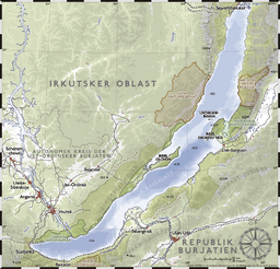
බයිකල් විල
Appearance
| බයිකල් විල | |
|---|---|
 | |
 | |
| ස්ථානය | Siberia, Russia |
| Coordinates | 53°30′N 108°0′E / 53.500°N 108.000°Eඛණ්ඩාංක: 53°30′N 108°0′E / 53.500°N 108.000°E |
| Lake type | Continental rift lake |
| Primary inflows | Selenge, Barguzin, Upper Angara |
| Primary outflows | Angara |
| Catchment area | 560,000 km2 (216,000 sq mi) |
| Basin countries | Russia and Mongolia |
| උපරිම දිග | 636 km (395 mi) |
| උපරිම පළල | 79 km (49 mi) |
| Surface area | 31,722 km2 (12,248 sq mi)[1] |
| Average depth | 744.4 m (2,442 ft)[1] |
| උපරිම ගැඹුර | 1,642 m (5,387 ft)[1] |
| Water volume | 23,615.39 km3 (5,700 cu mi)[1] |
| Residence time | 330 years[2] |
| Shore length1 | 2,100 km (1,300 mi) |
| Surface elevation | 455.5 m (1,494 ft) |
| Frozen | January–May |
| Islands | 27 (Olkhon) |
| Settlements | Irkutsk |
| Type | Natural |
| Criteria | vii, viii, ix, x |
| Designated | 1996 (22nd session) |
| Reference no. | 754 |
| State Party | Russia |
| Region | Asia |
| 1 Shore length is not a well-defined measure. | |
බයිකල් විල (ඉංග්රීසි: Lake Baikal), රුසියාවේ පි හිටි විලකි.
මූලාශ්ර
[සංස්කරණය]- ^ a b c d "A new bathymetric map of Lake Baikal. MORPHOMETRIC DATA. INTAS Project 99-1669.Ghent University, Ghent, Belgium; Consolidated Research Group on Marine Geosciences (CRG-MG), University of Barcelona, Spain; Limnological Institute of the Siberian Division of the Russian Academy of Sciences, Irkutsk, Russian Federation; State Science Research Navigation-Hydrographic Institute of the Ministry of Defense, St.Petersburg, Russian Federation". Ghent University, Ghent, Belgium. සම්ප්රවේශය 9 July 2009.
- ^ M.A. Grachev. "On the present state of the ecological system of lake Baikal". Lymnological Institute, Siberian Division of the Russian Academy of Sciences. සම්ප්රවේශය 9 July 2009.
