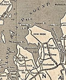
නැසූ ප්රාන්තය, නිව්යෝර්ක්
Appearance
| නැසූ ප්රාන්තය, නිව්යෝර්ක් | |||
|---|---|---|---|
| County | |||
| County of Nassau | |||
 Hempstead House, part of Sands Point Preserve, on Nassau County's Gold Coast, home to some of the world's most expensive real estate | |||
| |||
| Map of නිව්යෝර්ක් highlighting නැසූ ප්රාන්තය Location in the U.S. state of නිව්යෝර්ක් | |||
 නිව්යෝර්ක්'s location in the U.S. | |||
| Founded | 1899 | ||
| Named for | House of Nassau | ||
| Seat | Mineola | ||
| Largest town | Hempstead | ||
| Area | |||
| • Total | 453 sq mi (1,173 km2) | ||
| • Land | 285 sq mi (738 km2) | ||
| • Water | 169 sq mi (438 km2), 37 | ||
| Population | |||
| • (2020) | 1,395,774 | ||
| • Density | 4,897.45/sq mi (auto/km²) | ||
| Area code(s) | 516, 363 | ||
| Congressional districts | 2nd, 3rd, 4th | ||
| Time zone | Eastern: UTC-5/-4 | ||
| Website | nassaucountyny.gov | ||
| Footnotes: Population is 2020 official census | |||
| මෙම ලිපිය |
| ලොන්ග් අයිලන්ඩ් |
|---|
| පිළිබඳ ලීපි මාලාවක කොටසකි |
 |
| Topics |
| Regions |

නැසූ කවුන්ටි (ඉංග්රීසි: Nassau County, /ˈnæsɔː/ NASS-aw), යනු ලොන්ග් අයිලන්ඩ් හි පිහිටා ඇති උප නාගරික කවුන්ටියක් වෙයි. 2020 එක්සත් රාජ්ය සංගණනයට අනුව, මෙහි ජනගහණය 1,395,774 වෙයි. ඒ අනුව නිව්යෝක් රාජ්යයේ හයවන (6) වැඩිම ජනගණය සහිත කවුන්ටිය ලෙස දැක්විය හැකිය.[1]
භූගෝලීය ලක්ෂණ
[සංස්කරණය]

එක්සත් රාජ්ය සංගණන කාර්යාංශයට අනුව, කවුන්ටියේ මුළු වපසරිය 453.2 square miles (1,174 km2) වෙයි. ඉන් 284.7 square miles (737 km2) ගොඩබිම වන අතර 168.5 square miles (436 km2) එනම් 37% ක් ජලය වෙයි.[2]
Countyscape
[සංස්කරණය]දේශගුණය
[සංස්කරණය]| Climate data for Mineola, New York | |||||||||||||
|---|---|---|---|---|---|---|---|---|---|---|---|---|---|
| Month | Jan | Feb | Mar | Apr | May | Jun | Jul | Aug | Sep | Oct | Nov | Dec | Year |
| Record high °F (°C) | 71 (22) |
73 (23) |
85 (29) |
94 (34) |
97 (36) |
101 (38) |
105 (41) |
104 (40) |
100 (38) |
90 (32) |
83 (28) |
76 (24) |
105 (41) |
| Mean daily maximum °F (°C) | 39 (4) |
43 (6) |
50 (10) |
61 (16) |
70 (21) |
80 (27) |
85 (29) |
83 (28) |
76 (24) |
65 (18) |
55 (13) |
45 (7) |
63 (17) |
| Mean daily minimum °F (°C) | 26 (−3) |
28 (−2) |
34 (1) |
42 (6) |
51 (11) |
61 (16) |
66 (19) |
65 (18) |
58 (14) |
48 (9) |
40 (4) |
31 (−1) |
46 (8) |
| Record low °F (°C) | −10 (−23) |
−7 (−22) |
3 (−16) |
13 (−11) |
32 (0) |
43 (6) |
50 (10) |
48 (9) |
38 (3) |
27 (−3) |
10 (−12) |
−1 (−18) |
−10 (−23) |
| Average precipitation inches (mm) | 3.62 (92) |
3.17 (81) |
4.35 (110) |
4.15 (105) |
3.90 (99) |
3.85 (98) |
4.40 (112) |
3.72 (94) |
3.91 (99) |
4.08 (104) |
3.73 (95) |
3.82 (97) |
46.7 (1,186) |
| Source: The Weather Channel[3] | |||||||||||||
අමතර අවධානයට
[සංස්කරණය]- List of counties in New York
- List of Long Islanders
- Nassau County International Cricket Stadium
- Nassau County Police Department
- Nassau Inter-County Express
- National Register of Historic Places listings in Nassau County, New York
මූලාශ්ර
[සංස්කරණය]- ^ "QuickFacts Nassau County, New York". United States Census Bureau. January 31, 2023 දින පැවති මුල් පිටපත වෙතින් සංරක්ෂිත පිටපත. සම්ප්රවේශය March 16, 2023.
- ^ "2010 Census Gazetteer Files". United States Census Bureau. August 22, 2012. May 19, 2014 දින මුල් පිටපත වෙතින් සංරක්ෂණය කරන ලදී. සම්ප්රවේශය January 6, 2015.
- ^ "Monthly Averages for Mineola, NY (11501)". weatherco.com. The Weather Channel. සම්ප්රවේශය July 12, 2015.
භාහිර සබැඳි
[සංස්කරණය]නැසූ ප්රාන්තය, නිව්යෝර්ක් හා සබැඳි මාධ්ය විකිමාධ්ය කොමන්ස් හි ඇත.
විකිචාරිකා සතුව Nassau County සඳහා සංචාරක මාර්ගෝපදේයක් පවතියි.


