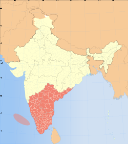
දක්ෂිණ භාරතය
Appearance
| දක්ෂිණ භාරතය | |
|---|---|
| කලාපය | |
 Map of states and union territories in South India | |
| රට | |
| States and union territories |
|
| Most populous cities | |
| සරිය | |
| • මුළු | 635,780 කිමී2 (245,480 සතරැස් සැත) |
| වැඩිම උස (Anamudi) | 2,695 මී (8,842 අඩි) |
| අඩුම උස (Kuttanad) | −2.2 මී (−7.2 අඩි) |
| ජනගහණය(2011) | |
| • මුළු | 253,051,953 |
| • ඝණත්වය | 400/කිමී2 (1,000/වර්ග සැත) |
| ජනනාමය(න්) | South Indian Dravidian Kannadiga Malayali Laccadivian Pondicherrian Tamilian Telugite |
| වේලා කලාප | IST (UTC+5:30) |
| නිල භාශා | |
| HDI (2019) | |
| Literacy (2011) | 81.09%[2] |
| Sex ratio (2011) | 986 ♀/1000 ♂[3] |
| සුළුතර භාෂා | |
- ^ "In the land of many tongues, Hindi can't be lingua franca". Deccan Chronicle. 9 June 2019.
- ^ "Literacy Survey, India (2017–18)". Firstpost. 8 September 2020. සම්ප්රවේශය 9 September 2020.
- ^ "Census 2011 (Final Data) – Demographic details, Literate Population (Total, Rural & Urban)" (PDF). planningcommission.gov.in. Planning Commission, Government of India. 27 January 2018 දින මුල් පිටපත (PDF) වෙතින් සංරක්ෂණය කරන ලදී. සම්ප්රවේශය 3 October 2018.
