
ගොනුව:Satellitemarion.jpg
මෙයට ඉහල විසර්ජනයක් ලබාගත නොහැක.
Satellitemarion.jpg (546 × 371 පික්සල, ගොනු විශාලත්වය: 51 කි.බ., MIME ශෛලිය: image/jpeg)
සාරාංශය
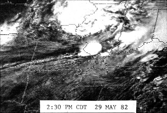
| විස්තරය | Satellite picture of the clouds that produced the Marion, Illinois tornado. |
| දිනය | 29 මැයි 1982 14:30 CDT; 30 දෙසැම්බර් 2007 (original upload date) |
| මූලාශ්රය | http://www.crh.noaa.gov/pah/?n=1982_Photos |
| කර්තෘ | National Weather Service |
| අවසරය (මෙම ගොනුව නැවත භාවිතා කරමින්) |
Public domain |
බලපත්රීකරණය
This image is in the public domain because it contains materials that originally came from the U.S. National Oceanic and Atmospheric Administration, taken or made as part of an employee's official duties.
|
ගොනු ඉතිහාසය
එම අවස්ථාවෙහිදී ගොනුව පැවැති ආකාරය නැරඹීමට දිනය/වේලාව මත ක්ලික් කරන්න.
| දිනය/වේලාව | කුඩා-රූපය | මාන | පරිශීලක | පරිකථනය | |
|---|---|---|---|---|---|
| වත්මන් | 20:44, 30 දෙසැම්බර් 2007 | | 546 × 371 (51 කි.බ.) | Southern Illinois SKYWARN | {{Information |Description= Satellite picture of the clouds that produced the Marion, Illinois tornado. |Source= http://www.crh.noaa.gov/pah/?n=1982_Photos |Date= 12/30/2007 |Author= National Weather Service |Permission= Public domain |other_versions= }} |
ගොනු භාවිතය
පහත දැක්වෙන පිටුව විසින් මෙම ගොනුව භාවිතා කෙරෙයි:
ගෝලීය ගොනු භාවිතය
පහත දැක්වෙන අනෙකුත් විකියන් මගින් මෙම ගොනුව භාවිතා කරයි:
- en.wikipedia.org හි භාවිතය