
ගොනුව:Political map of the World (November 2011).png
මෙම පෙරදසුනෙහි විශාලත්වය: 800 × 437 පික්සල. අනෙකුත් විභේදනයන්: 320 × 175 පික්සල | 640 × 350 පික්සල | 1,024 × 560 පික්සල | 1,280 × 700 පික්සල | 2,560 × 1,400 පික්සල | 4,572 × 2,500 පික්සල.
මුල් ගොනුව (4,572 × 2,500 පික්සල, ගොනු විශාලත්වය: 3.46 මෙ.බ., MIME ශෛලිය: image/png)
සාරාංශය

|
This file requires updating because: s/CZECH REP./CZECHIA; s/SWAZILAND/eSWATINI; label TAIWAN separately from CHINA In doing so, you could add a timestamp to the file.
|
| විස්තරය |
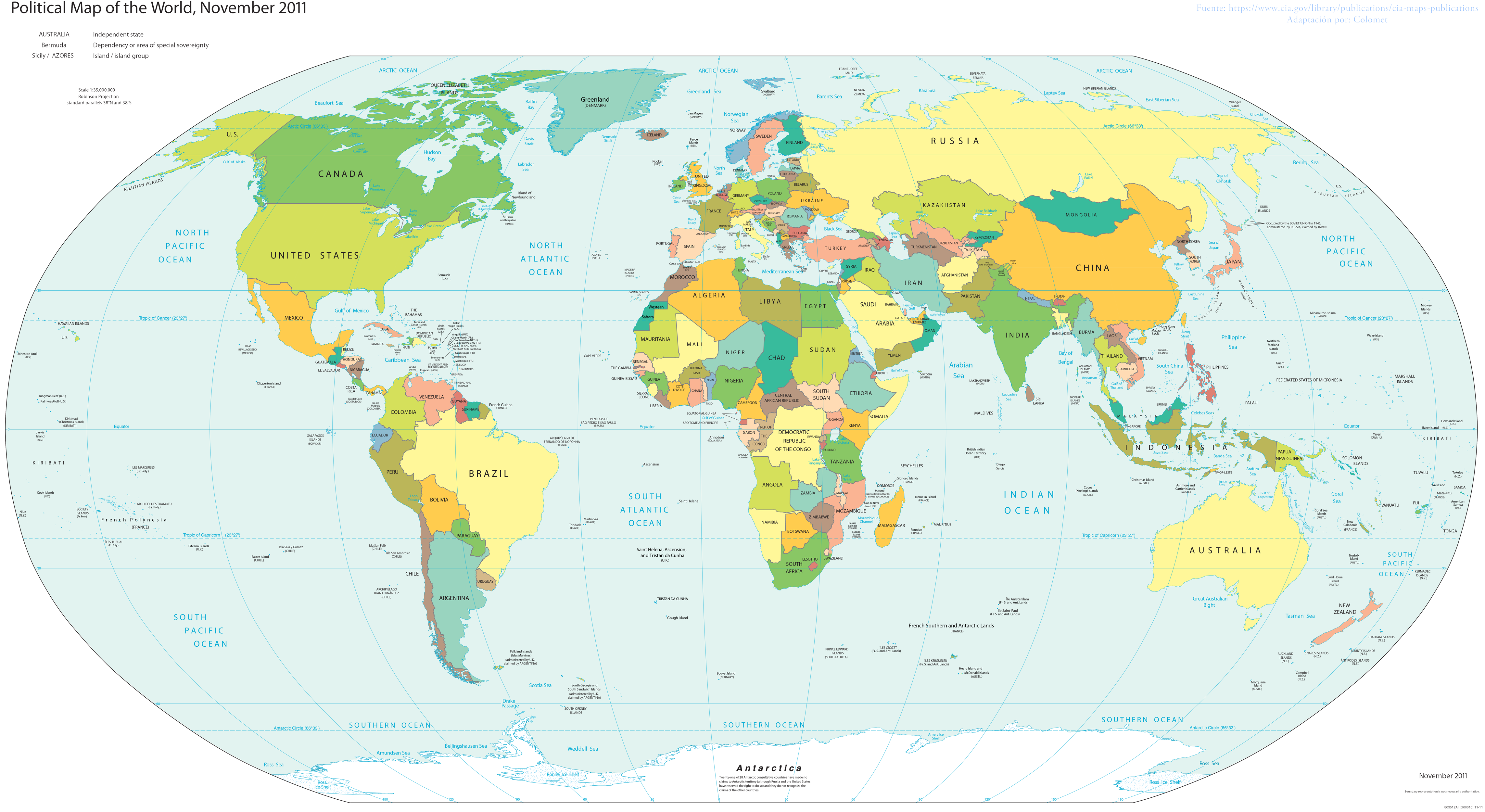
English: World map; partially inaccurate, as Taiwan is shown as part of China. POV-pushing users have reverted attempts to update this map to include other partially-unrecognized countries, due to the 2011 date on the map; however, South Sudan did not exist in 2011, and it's still on the map. |
| දිනය | |
| මූලාශ්රය | Basado en el Mapa politico de la CIA |
| කර්තෘ | Colomet |
| අනෙකුත් අනුවාදයන් |
 |


.png)
බලපත්රීකරණය
මෙම කෘතියෙහි හිමිකම් අයිතීන් දරන්නා වන මම,පහත වරපත යටතේ එය ප්රකාශයට පත් කරමි:
මෙම ගොනුව ක්රියේටිව් කොමන්ස් Attribution-Share Alike 3.0 Unported වරපත යටතේ අවසර ලබා ඇත.
- ඔබ නිදහස්:
- බෙදාහදා ගැනීමට – කාර්යය පිටපත් කිරීමට,බෙදා හැරීමට සහ සම්ප්රේෂණය කිරීමට
- නැවත සංකලනය කිරීමට – කාර්යයට අනුවර්තනය වීමට
- පහත කොන්දේසිවලට යටත්ව:
- attribution – වරපත වෙත බැඳියක්ද සපයමින් ඔබ විසින් සුදුසු කර්තෘභාරය ප්රදානය කල යුතු අතර, කිසියම් වෙනස්වීම් සිදුකලේ නම් එයද සඳහන් කල යුතු වෙයි. ඕනෑම සුදුසු ආකාරයට මෙය ඔබ විසින් සිදුකල හැකි මුත්, වරපත්දායකයා විසින් ඔබ හෝ ඔබගේ භාවිතය හෝ පිටසන් කරන බවට ඇඟවෙන ලෙසින් එය සිදු නොකල යුතු වෙයි.
- share alike – මෙම විෂය කාරණා භාවිතා කොට නැවත සංකලනය, ප්රතියෝජනය හෝ වැඩිදියුණුව කලේ නම්, ඉන්පසු ඔබගේ දායකත්වය ඔබ විසින් බෙදාහැරිය යුත්තේ මුල් වරපත හා සමාන හෝ සංගතික හෝ වරපතක් භාවිතා කරමිනි.
This image is in the public domain because it contains materials that originally came from the United States Central Intelligence Agency's World Factbook.
|
 |
ගොනු ඉතිහාසය
එම අවස්ථාවෙහිදී ගොනුව පැවැති ආකාරය නැරඹීමට දිනය/වේලාව මත ක්ලික් කරන්න.
.png&dir=prev)
.png&offset=20170108210230)
.png&offset=&limit=20)
.png&offset=&limit=50)
.png&offset=&limit=100)
.png&offset=&limit=250)
.png&offset=&limit=500)
| දිනය/වේලාව | කුඩා-රූපය | මාන | පරිශීලක | පරිකථනය | |
|---|---|---|---|---|---|
| වත්මන් | 18:00, 24 නොවැම්බර් 2017 | | 4,572 × 2,500 (3.46 මෙ.බ.) | Rob984 | Reverted to version as of 23:35, 16 November 2017 (UTC) Crimea wasn't controlled by Russia in November 2011. Please fix the date. Also dont add Turkish occupation zones as Turkey, they are not. |
| 19:17, 23 නොවැම්බර් 2017 |  | 4,572 × 2,500 (3.43 මෙ.බ.) | Koxem918 | Slight coloring fix in Russian area around Abkhazia. | |
| 19:13, 23 නොවැම්බර් 2017 |  | 4,572 × 2,500 (3.43 මෙ.බ.) | Koxem918 | Added back in Russian control over Ukraine as well as Turkish control of northern Syria, neither of which had been established when the map was created. Also added back in Abkhazia. | |
| 23:35, 16 නොවැම්බර් 2017 |  | 4,572 × 2,500 (3.46 මෙ.බ.) | Mitolith | Reverted to version as of 23:13, 31 January 2012 (UTC) | |
| 02:37, 30 ජූලි 2017 |  | 4,572 × 2,500 (2.79 මෙ.බ.) | Salem.leo.1 | Added in Donetsk's People's Republic, South Ossetia, Abkhazia | |
| 21:03, 26 මාර්තු 2017 |  | 4,572 × 2,500 (3.43 මෙ.බ.) | Salem Leo | Added in Kosovo. | |
| 19:58, 26 මාර්තු 2017 |  | 4,572 × 2,500 (3.43 මෙ.බ.) | Salem Leo | Added in area controlled by Turkey in Northern Syria due to Operation Euphrates Shield. | |
| 18:45, 26 මාර්තු 2017 |  | 4,572 × 2,500 (3.41 මෙ.බ.) | Salem Leo | Colouring fix. | |
| 21:04, 8 ජනවාරි 2017 |  | 4,572 × 2,500 (3.43 මෙ.බ.) | Rob984 | Reverted to version as of 03:16, 30 November 2016 (UTC) ISIS is not a recognised country.... | |
| 21:02, 8 ජනවාරි 2017 |  | 4,572 × 2,500 (3.43 මෙ.බ.) | Rob984 | Reverted to version as of 04:11, 30 November 2016 (UTC) |
ගොනු භාවිතය
පහත දැක්වෙන පිටුව විසින් මෙම ගොනුව භාවිතා කෙරෙයි:
ගෝලීය ගොනු භාවිතය
පහත දැක්වෙන අනෙකුත් විකියන් මගින් මෙම ගොනුව භාවිතා කරයි:
- ar.wikipedia.org හි භාවිතය
- awa.wikipedia.org හි භාවිතය
- crh.wikipedia.org හි භාවිතය
- cv.wikipedia.org හි භාවිතය
- en.wikipedia.org හි භාවිතය
- eo.wikipedia.org හි භාවිතය
- es.wikipedia.org හි භාවිතය
- fa.wikiquote.org හි භාවිතය
- fi.wikipedia.org හි භාවිතය
- gl.wikipedia.org හි භාවිතය
- ha.wikipedia.org හි භාවිතය
- he.wikipedia.org හි භාවිතය
- ht.wikipedia.org හි භාවිතය
- incubator.wikimedia.org හි භාවිතය
- ka.wikipedia.org හි භාවිතය
- lo.wikipedia.org හි භාවිතය
- nl.wikipedia.org හි භාවිතය
- pt.wikipedia.org හි භාවිතය
- ru.wikipedia.org හි භාවිතය
- sco.wikipedia.org හි භාවිතය
- sv.wikipedia.org හි භාවිතය
- th.wikipedia.org හි භාවිතය
- tly.wikipedia.org හි භාවිතය
- uk.wikipedia.org හි භාවිතය
- za.wikipedia.org හි භාවිතය
.png)