
ගොනුව:Prague districts en.svg

Size of this PNG preview of this SVG file: 800 × 600 පික්සල. අනෙකුත් විභේදනයන්: 320 × 240 පික්සල | 640 × 480 පික්සල | 1,024 × 768 පික්සල | 1,280 × 960 පික්සල | 2,560 × 1,920 පික්සල.
මුල් ගොනුව (SVG ගොනුව, නාමමාත්රිකව 1,024 × 768 පික්සල්, ගොනු විශාලත්වය: 1,002 කි.බ.)
| විස්තරය |
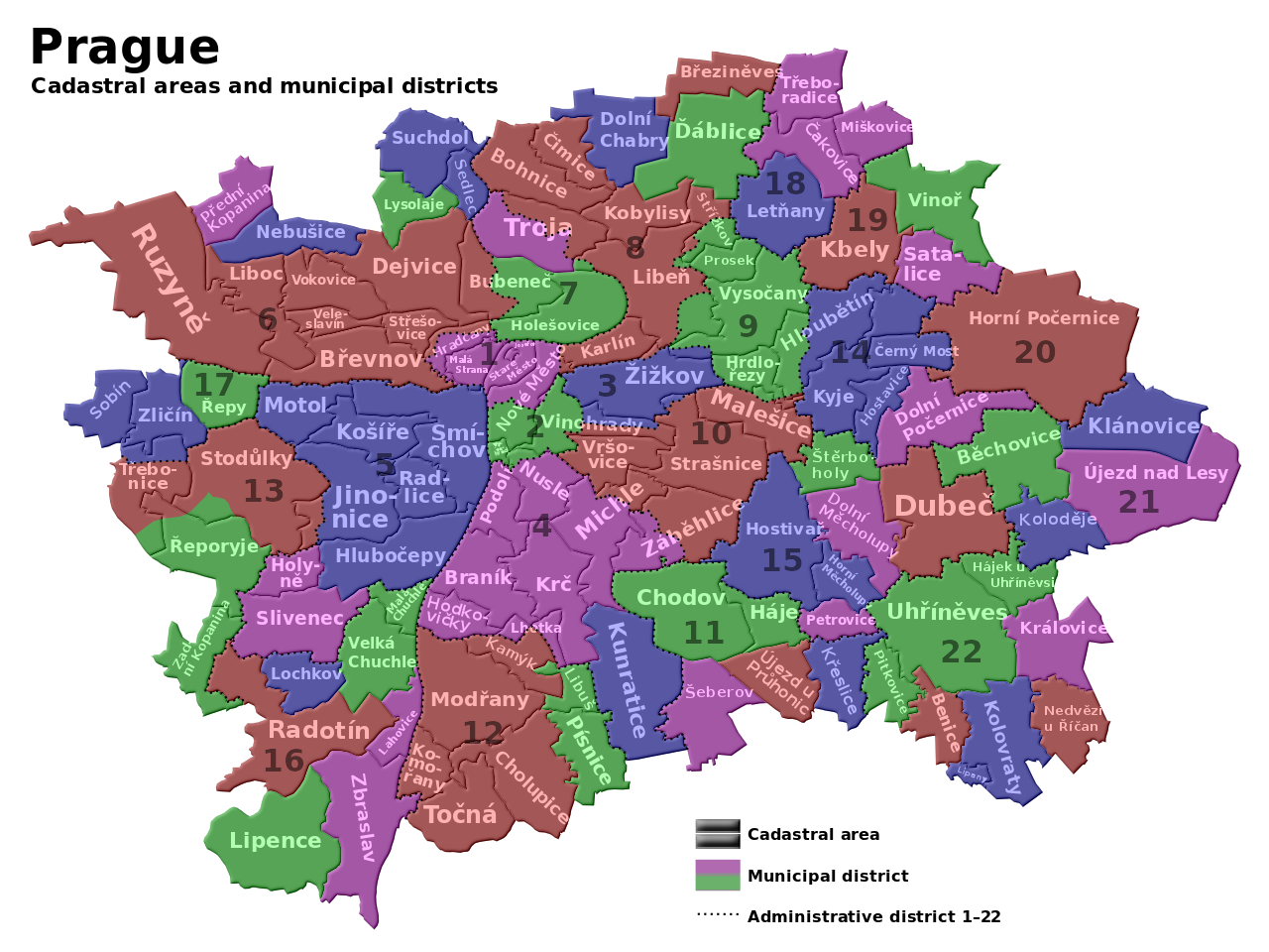
English: Maps of Prague cadastre and administratice districts Čeština: Mapa pražských katastrálních území a městských částí |
| දිනය | (UTC) |
| මූලාශ්රය | |
| කර්තෘ |
|
| This is a retouched picture, which means that it has been digitally altered from its original version. Modifications: legend translated into English. The original can be viewed here: Prague districts.svg:
|
I, මෙම කාර්යයේ ප්රකාශන අයිතිය දරන්නා,පහත බලපත්රය යටතේ එය ප්රකාශයට පත් කරනු ලබයි:
මෙම ගොනුව ක්රියේටිව් කොමන්ස් Attribution-Share Alike 3.0 Unported වරපත යටතේ අවසර ලබා ඇත.
- ඔබ නිදහස්:
- බෙදාහදා ගැනීමට – කාර්යය පිටපත් කිරීමට,බෙදා හැරීමට සහ සම්ප්රේෂණය කිරීමට
- නැවත සංකලනය කිරීමට – කාර්යයට අනුවර්තනය වීමට
- පහත කොන්දේසිවලට යටත්ව:
- attribution – වරපත වෙත බැඳියක්ද සපයමින් ඔබ විසින් සුදුසු කර්තෘභාරය ප්රදානය කල යුතු අතර, කිසියම් වෙනස්වීම් සිදුකලේ නම් එයද සඳහන් කල යුතු වෙයි. ඕනෑම සුදුසු ආකාරයට මෙය ඔබ විසින් සිදුකල හැකි මුත්, වරපත්දායකයා විසින් ඔබ හෝ ඔබගේ භාවිතය හෝ පිටසන් කරන බවට ඇඟවෙන ලෙසින් එය සිදු නොකල යුතු වෙයි.
- share alike – මෙම විෂය කාරණා භාවිතා කොට නැවත සංකලනය, ප්රතියෝජනය හෝ වැඩිදියුණුව කලේ නම්, ඉන්පසු ඔබගේ දායකත්වය ඔබ විසින් බෙදාහැරිය යුත්තේ මුල් වරපත හා සමාන හෝ සංගතික හෝ වරපතක් භාවිතා කරමිනි.

|
Free Software Foundation විසින් ප්රකාශිත GNU Free Documentation License බලපත්රයෙහි 1.2 හෝ ඊට අලුත් පිටපත්වල කොන්දේසිවලට යටත්ව මෙම ගොනුව පිටපත් කෙරුමට, නැවත බෙදාහාරුමට සහ/හෝ වෙනස් කෙරුමට අවසර දී ඇත; ඒ වෙනස් අංශ නොමැතිව, මුල් පිටු පෙළ නොමැතිව, පසු පිටු පෙළ නොමැතිවය. බලපත්රයේ පිටපතක් GNU Free Documentation License නම් අංශයේ දැක්වේ. |
ඔබට අභිමත වරපත තෝරාගත හැක.
ප්රකෘති පැටවුම් ලොගය
This image is a derivative work of the following images:
- File:Prague_districts.svg licensed with Cc-by-sa-3.0, GFDL
- 2009-05-09T12:09:00Z Kubiik 1024x768 (1026372 Bytes) Troja is separated part
- 2009-03-09T09:37:00Z Kubiik 1024x768 (1026361 Bytes) More accurate and shadow borders
- 2009-02-05T12:37:28Z Kubiik 1313x990 (905164 Bytes) {{Information |Description={{en|1=Maps of Prague cadastre and administratice districts}} {{cs|1=Mapa pražských katastrálních území a městských částí}} |Source=Own work by uploader |Author=[[User:Kubiik|Kubiik]] |Da
Uploaded with derivativeFX
ගොනු ඉතිහාසය
එම අවස්ථාවෙහිදී ගොනුව පැවැති ආකාරය නැරඹීමට දිනය/වේලාව මත ක්ලික් කරන්න.
| දිනය/වේලාව | කුඩා-රූපය | මාන | පරිශීලක | පරිකථනය | |
|---|---|---|---|---|---|
| වත්මන් | 14:54, 11 මැයි 2009 | | 1,024 × 768 (1,002 කි.බ.) | DavidSpanel | {{Information |Description={{en|1=Maps of Prague cadastre and administratice districts}} {{cs|1=Mapa pražských katastrálních území a městských částí}} |Source=*File:Prague_districts.svg |Date=2009-05-11 15:53 (UTC) |Author=*[[:File:Prague |
ගොනු භාවිතය
පහත දැක්වෙන පිටු 2 ක් විසින් මෙම ගොනුව භාවිතා කෙරෙයි:
ගෝලීය ගොනු භාවිතය
පහත දැක්වෙන අනෙකුත් විකියන් මගින් මෙම ගොනුව භාවිතා කරයි:
- an.wikipedia.org හි භාවිතය
- ar.wikipedia.org හි භාවිතය
- azb.wikipedia.org හි භාවිතය
- ceb.wikipedia.org හි භාවිතය
- en.wikipedia.org හි භාවිතය
- es.wikipedia.org හි භාවිතය
- fa.wikipedia.org හි භාවිතය
- fr.wikipedia.org හි භාවිතය
- hu.wikipedia.org හි භාවිතය
- uk.wikipedia.org හි භාවිතය
- uz.wikipedia.org හි භාවිතය
- war.wikipedia.org හි භාවිතය