
ගොනුව:Nottinghamshire UK location map.svg

Size of this PNG preview of this SVG file: 473 × 599 පික්සල. අනෙකුත් විභේදනයන්: 189 × 240 පික්සල | 379 × 480 පික්සල | 606 × 768 පික්සල | 808 × 1,024 පික්සල | 1,616 × 2,048 පික්සල | 1,030 × 1,305 පික්සල.
මුල් ගොනුව (SVG ගොනුව, නාමමාත්රිකව 1,030 × 1,305 පික්සල්, ගොනු විශාලත්වය: 1.95 මෙ.බ.)
| විස්තරය |
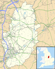
Map of Nottinghamshire, UK with the following information shown:
Equirectangular map projection on WGS 84 datum, with N/S stretched 165% Geographic limits:
|
| දිනය | |
| මූලාශ්රය |
|
| කර්තෘ | Nilfanion, created using Ordnance Survey data |
| අවසරය (මෙම ගොනුව නැවත භාවිතා කරමින්) |
මෙම ගොනුව ක්රියේටිව් කොමන්ස් Attribution-Share Alike 3.0 Unported වරපත යටතේ අවසර ලබා ඇත. Attribution: Contains Ordnance Survey data © Crown copyright and database right
|
| අනෙකුත් අනුවාදයන් | File:Nottinghamshire UK district map (blank).svg - Blank map |
.svg)
ගොනු ඉතිහාසය
එම අවස්ථාවෙහිදී ගොනුව පැවැති ආකාරය නැරඹීමට දිනය/වේලාව මත ක්ලික් කරන්න.
| දිනය/වේලාව | කුඩා-රූපය | මාන | පරිශීලක | පරිකථනය | |
|---|---|---|---|---|---|
| වත්මන් | 19:09, 26 සැප්තැම්බර් 2010 | | 1,030 × 1,305 (1.95 මෙ.බ.) | Nilfanion | {{Information |Description=Map of Nottinghamshire, UK with the following information shown: *Administrative borders *Coastline, lakes and rivers *Roads and railways *Urban areas Equirectangular map projection on WGS 84 datum, with N |
ගොනු භාවිතය
පහත දැක්වෙන පිටු 3 ක් විසින් මෙම ගොනුව භාවිතා කෙරෙයි:
ගෝලීය ගොනු භාවිතය
පහත දැක්වෙන අනෙකුත් විකියන් මගින් මෙම ගොනුව භාවිතා කරයි:
- ar.wikipedia.org හි භාවිතය
- bg.wikipedia.org හි භාවිතය
- br.wikipedia.org හි භාවිතය
- ceb.wikipedia.org හි භාවිතය
- en.wikipedia.org හි භාවිතය
- Newstead Abbey
- Beeston, Nottinghamshire
- Blyth, Nottinghamshire
- Worksop
- Newark-on-Trent
- Edwinstowe
- Nottingham Castle
- Gotham, Nottinghamshire
- Eastwood, Nottinghamshire
- Retford
- Ollerton
- Kimberley, Nottinghamshire
- The Park Estate
- Sutton Bonington
- Queen's Medical Centre
- Calverton, Nottinghamshire
- Wollaton Hall
- Hucknall
- Arnold, Nottinghamshire
- Bircotes
- Manton, Nottinghamshire
- Scrooby
- Carlton, Nottinghamshire
- Bingham, Nottinghamshire
- West Bridgford
- Sutton-in-Ashfield
- Gamston, Rushcliffe
- Cotgrave
- RAF Syerston
- Blidworth
- Lenton, Nottingham
- Kirkby-in-Ashfield
- Tollerton, Nottinghamshire
- Rampton Secure Hospital
- Holme Pierrepont
- Zouch
- Nottingham station
- Mansfield Woodhouse
- Toton
- Redhill, Nottinghamshire
- Aslockton
- Clumber Park
- Spion Kop, Nottinghamshire
- Chilwell
- Radford, Nottingham
මෙම ගොනුවේ තවත් ගෝලීය භාවිත බලන්න.