
ගොනුව:Ponta de São Lourenço north north east.jpg

මෙම පෙරදසුනෙහි විශාලත්වය: 800 × 366 පික්සල. අනෙකුත් විභේදනයන්: 320 × 146 පික්සල | 640 × 293 පික්සල | 1,024 × 468 පික්සල | 1,280 × 585 පික්සල | 2,560 × 1,170 පික්සල | 10,000 × 4,571 පික්සල.
මුල් ගොනුව (10,000 × 4,571 පික්සල, ගොනු විශාලත්වය: 5.28 මෙ.බ., MIME ශෛලිය: image/jpeg)
සාරාංශය
| විස්තරය |
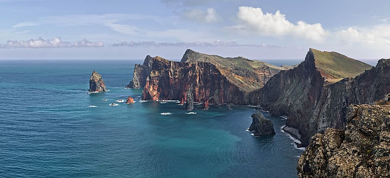
Deutsch: Ponta de São Lourenço, Madeira, Portugal. Blickrichtung Nord Nord Ost.
English: Ponta de São Lourenço, Madeira, Portugal. Heading north north east.
বাংলা: পোঁতা দে সাঁও লোরেসন্সু, মদিরা, পর্তুগাল। উত্তর উত্তর পূর্ব হতে ।
فارسی: پونتا د سائو لورنسو، جزایر مادیرا، پرتقال. این جزایر متعلق به کشور پرتقال است و در اقیانوس اطلس قرار دارد. |
| දිනය | |
| මූලාශ්රය | ස්වයං නිර්මාණයකි |
| කර්තෘ | Richard Bartz |
| අවසරය (මෙම ගොනුව නැවත භාවිතා කරමින්) |
මෙම ගොනුව ක්රියේටිව් කොමන්ස් Attribution-Share Alike 3.0 Unported වරපත යටතේ අවසර ලබා ඇත.
|
|
This image was selected as picture of the day on Wikimedia Commons for 1 March 2014. It was captioned as follows: English: Ponta de São Lourenço, Madeira, Portugal. Other languages:
Bosanski: Ponta de São Lourenço na portugalskom ostrvu Madeira. English: Ponta de São Lourenço, Madeira, Portugal. Русский: Побережье острова Мадейра в районе природного заповедника «Понта-де-Сан-Лоуренсу». বাংলা : পোঁতা দে সাঁও লোরেসন্সু, মদিরা, পর্তুগাল। উত্তর উত্তর পূর্ব হতে । 中文: 葡萄牙马德拉圣洛伦索角。 |
| Camera location | | View this and other nearby images on: OpenStreetMap |
|---|

|
This image has been assessed under the valued image criteria and is considered the most valued image on Commons within the scope: Western part of Ponta de São Lourenço. You can see its nomination here. |
This image has been assessed using the Quality image guidelines and is considered a Quality image.
|
ගොනු ඉතිහාසය
එම අවස්ථාවෙහිදී ගොනුව පැවැති ආකාරය නැරඹීමට දිනය/වේලාව මත ක්ලික් කරන්න.
| දිනය/වේලාව | කුඩා-රූපය | මාන | පරිශීලක | පරිකථනය | |
|---|---|---|---|---|---|
| වත්මන් | 13:36, 22 දෙසැම්බර් 2013 | | 10,000 × 4,571 (5.28 මෙ.බ.) | Richard Bartz | Minor fix |
| 12:39, 22 දෙසැම්බර් 2013 |  | 10,000 × 4,571 (5.28 මෙ.බ.) | Richard Bartz | == {{int:filedesc}} == {{Information |Description={{mld |de=''' Ponta de São Lourenço''' Madeira, Portugal. Blickrichtung Nord Nord Ost. |en='''Ponta de São Lourenço''' Madeira, Portugal. Heading north north east. |Source = {{Own}} |Date = 2013-112... |
ගොනු භාවිතය
මෙම ගොනුව භාවිතා කරන නිසිදු පිටුවක් නොමැත.
ගෝලීය ගොනු භාවිතය
පහත දැක්වෙන අනෙකුත් විකියන් මගින් මෙම ගොනුව භාවිතා කරයි:
- be-tarask.wikipedia.org හි භාවිතය
- bn.wikipedia.org හි භාවිතය
- crh.wikipedia.org හි භාවිතය
- cv.wikipedia.org හි භාවිතය
- de.wikipedia.org හි භාවිතය
- dsb.wikipedia.org හි භාවිතය
- en.wikipedia.org හි භාවිතය
- User:Richard Bartz
- Wikipedia:Wikipedia Signpost/2014-03-05/Discussion report
- Wikipedia:Wikipedia Signpost/Single/2014-03-05
- User:JeffKobs
- User:Georgiarts
- Ponta de São Lourenço
- Frederico Cunha
- User:Morneo06
- Talk:Madeira/Archive 1
- User:BlueSentinel122/sandbox
- Wikipedia:Wikipedia Signpost/2022-05-29/Gallery
- Wikipedia:Wikipedia Signpost/Single/2022-05-29
- en.wiktionary.org හි භාවිතය
- es.wikipedia.org හි භාවිතය
- Madeira
- Isla de Madeira
- Wikipedia:Imágenes destacadas/Lugares/Europa
- Wikipedia:Recurso del día/701 - 800
- Anexo:Lugares de importancia comunitaria de Portugal
- Wikipedia:Candidatos a recursos destacados/Febrero-2015
- Wikipedia:Candidatos a recursos destacados/Ponta de São Lourenço north north east.jpg
- Wikipedia:Recurso del día/marzo de 2015
- Plantilla:RDD/756
- Wikipedia:Recurso del día/noviembre de 2015
- Wikipedia:Recurso del día/enero de 2018
- Wikipedia:Recurso del día/abril de 2020
- Wikipedia:Recurso del día/noviembre de 2022
- eu.wikipedia.org හි භාවිතය
- fa.wikipedia.org හි භාවිතය
මෙම ගොනුවේ තවත් ගෝලීය භාවිත බලන්න.