
ගොනුව:Yangtze River Map.png
මෙයට ඉහල විසර්ජනයක් ලබාගත නොහැක.
Yangtze_River_Map.png (576 × 355 පික්සල, ගොනු විශාලත්වය: 123 කි.බ., MIME ශෛලිය: image/png)
සාරාංශය
| විස්තරය |
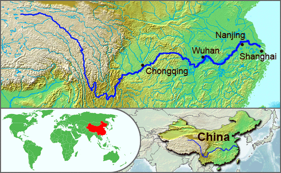
English: The underlying topographic maps used in this image come from the Demis Web Map Server, and are in the public domain. The world locator map is derived from :Image:BlankMap-World.png. I added the feature layers myself. —Papayoung ☯ 20:57, 1 October 2005 (UTC) |
| දිනය | 1 ඔක්තෝබර් 2005 (original upload date) |
| මූලාශ්රය | Transferred from en.wikipedia to Commons by Common Good using CommonsHelper. |
| කර්තෘ | The original uploader was Papayoung at ඉංග්රීසි විකිපීඩියා. |
| අනෙකුත් අනුවාදයන් |
|
.JPG)
බලපත්රීකරණය
| මෙම ගොනුව ක්රියේටිව් කොමන්ස් Attribution-Share Alike 3.0 Unported වරපත යටතේ අවසර ලබා ඇත. Subject to disclaimers. | ||
| ||
| GFDL බලපත්ර යාවත්කාල කෙරුමහි කොටසක් ලෙස මෙම ගොනුවට බලපත්ර ටැගය එක් කෙරිනි. |

|
Free Software Foundation විසින් ප්රකාශිත GNU Free Documentation License බලපත්රයෙහි 1.2 හෝ ඊට අලුත් පිටපත්වල කොන්දේසිවලට යටත්ව මෙම ගොනුව පිටපත් කෙරුමට, නැවත බෙදාහාරුමට සහ/හෝ වෙනස් කෙරුමට අවසර දී ඇත; ඒ වෙනස් අංශ නොමැතිව, මුල් පිටු පෙළ නොමැතිව, පසු පිටු පෙළ නොමැතිවය. බලපත්රයේ පිටපතක් GNU Free Documentation License නම් අංශයේ දැක්වේ. Subject to disclaimers. |
ප්රකෘති පැටවුම් ලොගය
The original description page was here. All following user names refer to en.wikipedia.
- 2005-10-01 20:51 Papayoung 576×355× (125604 bytes) The underlying topographic maps used in this image come from the [http://www2.demis.nl/mapserver/mapper.asp Demis Web Map Server], and are in the public domain. The world locator map is derived from [[Commons:Image:BlankMap-World.png|BlankMap-World.png]].
- 2005-09-25 22:57 Papayoung 936×363× (221574 bytes) The underlying topographic maps used in this image come from the [http://www2.demis.nl/mapserver/mapper.asp Demis Web Map Server], and are in the public domain. I added the feature layers myself. —~~~~
ගොනු ඉතිහාසය
එම අවස්ථාවෙහිදී ගොනුව පැවැති ආකාරය නැරඹීමට දිනය/වේලාව මත ක්ලික් කරන්න.
| දිනය/වේලාව | කුඩා-රූපය | මාන | පරිශීලක | පරිකථනය | |
|---|---|---|---|---|---|
| වත්මන් | 20:30, 7 මැයි 2009 | | 576 × 355 (123 කි.බ.) | File Upload Bot (Magnus Manske) | {{BotMoveToCommons|en.wikipedia|year={{subst:CURRENTYEAR}}|month={{subst:CURRENTMONTHNAME}}|day={{subst:CURRENTDAY}}}} {{Information |Description={{en|The underlying topographic maps used in this image come from the [http://www2.demis.nl/mapserver/mapper |
ගොනු භාවිතය
පහත දැක්වෙන පිටුව විසින් මෙම ගොනුව භාවිතා කෙරෙයි:
ගෝලීය ගොනු භාවිතය
පහත දැක්වෙන අනෙකුත් විකියන් මගින් මෙම ගොනුව භාවිතා කරයි:
- af.wikipedia.org හි භාවිතය
- als.wikipedia.org හි භාවිතය
- am.wikipedia.org හි භාවිතය
- ary.wikipedia.org හි භාවිතය
- ast.wikipedia.org හි භාවිතය
- as.wikipedia.org හි භාවිතය
- azb.wikipedia.org හි භාවිතය
- be-tarask.wikipedia.org හි භාවිතය
- bh.wikipedia.org හි භාවිතය
- bn.wikipedia.org හි භාවිතය
- bo.wikipedia.org හි භාවිතය
- br.wikipedia.org හි භාවිතය
- cs.wikipedia.org හි භාවිතය
- de.wikipedia.org හි භාවිතය
- en.wikipedia.org හි භාවිතය
- en.wikinews.org හි භාවිතය
- es.wikipedia.org හි භාවිතය
- et.wikipedia.org හි භාවිතය
- eu.wikipedia.org හි භාවිතය
- fi.wikipedia.org හි භාවිතය
- fo.wikipedia.org හි භාවිතය
- frr.wikipedia.org හි භාවිතය
- fr.wikipedia.org හි භාවිතය
- fr.wikivoyage.org හි භාවිතය
- fr.wiktionary.org හි භාවිතය
- fy.wikipedia.org හි භාවිතය
- hi.wikipedia.org හි භාවිතය
- hu.wikipedia.org හි භාවිතය
- hy.wikipedia.org හි භාවිතය
- hyw.wikipedia.org හි භාවිතය
- id.wikipedia.org හි භාවිතය
- ilo.wikipedia.org හි භාවිතය
- incubator.wikimedia.org හි භාවිතය
- io.wikipedia.org හි භාවිතය
- it.wikipedia.org හි භාවිතය
- ja.wikipedia.org හි භාවිතය
- ka.wikipedia.org හි භාවිතය
- ko.wikipedia.org හි භාවිතය
- ku.wikipedia.org හි භාවිතය
- la.wikipedia.org හි භාවිතය
- lfn.wikipedia.org හි භාවිතය
මෙම ගොනුවේ තවත් ගෝලීය භාවිත බලන්න.