
ගොනුව:West Bank location map.svg

Size of this PNG preview of this SVG file: 520 × 599 පික්සල. අනෙකුත් විභේදනයන්: 208 × 240 පික්සල | 417 × 480 පික්සල | 667 × 768 පික්සල | 889 × 1,024 පික්සල | 1,778 × 2,048 පික්සල | 639 × 736 පික්සල.
මුල් ගොනුව (SVG ගොනුව, නාමමාත්රිකව 639 × 736 පික්සල්, ගොනු විශාලත්වය: 106 කි.බ.)
සාරාංශය
| විස්තරය |
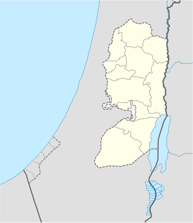
Deutsch: Positionskarte des Westjordanlandes
Quadratische Plattkarte, N-S-Streckung 115 %. Geographische Begrenzung der Karte:
English: Location map of the West Bank
Equirectangular projection, N/S stretching 115 %. Geographic limits of the map:
|
| දිනය | |
| මූලාශ්රය |
own work, using
|
| කර්තෘ | NordNordWest, little changes made by Obersachse |

|
This map has been made or improved in the German Kartenwerkstatt (Map Lab). You can propose maps to improve as well.
|
බලපත්රීකරණය
I, මෙම කාර්යයේ ප්රකාශන අයිතිය දරන්නා,පහත බලපත්රය යටතේ එය ප්රකාශයට පත් කරනු ලබයි:

|
Free Software Foundation විසින් ප්රකාශිත GNU Free Documentation License බලපත්රයෙහි 1.2 හෝ ඊට අලුත් පිටපත්වල කොන්දේසිවලට යටත්ව මෙම ගොනුව පිටපත් කෙරුමට, නැවත බෙදාහාරුමට සහ/හෝ වෙනස් කෙරුමට අවසර දී ඇත; ඒ වෙනස් අංශ නොමැතිව, මුල් පිටු පෙළ නොමැතිව, පසු පිටු පෙළ නොමැතිවය. බලපත්රයේ පිටපතක් GNU Free Documentation License නම් අංශයේ දැක්වේ. |
මෙම ගොනුව ක්රියේටිව් කොමන්ස් Attribution-Share Alike 3.0 Unported වරපත යටතේ අවසර ලබා ඇත.
- ඔබ නිදහස්:
- බෙදාහදා ගැනීමට – කාර්යය පිටපත් කිරීමට,බෙදා හැරීමට සහ සම්ප්රේෂණය කිරීමට
- නැවත සංකලනය කිරීමට – කාර්යයට අනුවර්තනය වීමට
- පහත කොන්දේසිවලට යටත්ව:
- attribution – වරපත වෙත බැඳියක්ද සපයමින් ඔබ විසින් සුදුසු කර්තෘභාරය ප්රදානය කල යුතු අතර, කිසියම් වෙනස්වීම් සිදුකලේ නම් එයද සඳහන් කල යුතු වෙයි. ඕනෑම සුදුසු ආකාරයට මෙය ඔබ විසින් සිදුකල හැකි මුත්, වරපත්දායකයා විසින් ඔබ හෝ ඔබගේ භාවිතය හෝ පිටසන් කරන බවට ඇඟවෙන ලෙසින් එය සිදු නොකල යුතු වෙයි.
- share alike – මෙම විෂය කාරණා භාවිතා කොට නැවත සංකලනය, ප්රතියෝජනය හෝ වැඩිදියුණුව කලේ නම්, ඉන්පසු ඔබගේ දායකත්වය ඔබ විසින් බෙදාහැරිය යුත්තේ මුල් වරපත හා සමාන හෝ සංගතික හෝ වරපතක් භාවිතා කරමිනි.
ඔබට අභිමත වරපත තෝරාගත හැක.
ගොනු ඉතිහාසය
එම අවස්ථාවෙහිදී ගොනුව පැවැති ආකාරය නැරඹීමට දිනය/වේලාව මත ක්ලික් කරන්න.
| දිනය/වේලාව | කුඩා-රූපය | මාන | පරිශීලක | පරිකථනය | |
|---|---|---|---|---|---|
| වත්මන් | 17:02, 6 සැප්තැම්බර් 2010 | | 639 × 736 (106 කි.බ.) | Obersachse | == {{int:filedesc}} == {{Information |Description= {{de|Positionskarte des Westjordanlandes}} Quadratische Plattkarte, N-S-Streckung 115 %. Geographische Begrenzung der Karte: * N: 32.7° N * S: 30.9° N * W: 34.0° O * O: 35.8° O {{en|Location map of th |
ගොනු භාවිතය
පහත දැක්වෙන පිටු 2 ක් විසින් මෙම ගොනුව භාවිතා කෙරෙයි:
ගෝලීය ගොනු භාවිතය
පහත දැක්වෙන අනෙකුත් විකියන් මගින් මෙම ගොනුව භාවිතා කරයි:
- ar.wikipedia.org හි භාවිතය
- ba.wikipedia.org හි භාවිතය
- bn.wikipedia.org හි භාවිතය
- bs.wikipedia.org හි භාවිතය
- ceb.wikipedia.org හි භාවිතය
- ckb.wikipedia.org හි භාවිතය
- da.wikipedia.org හි භාවිතය
- de.wikipedia.org හි භාවිතය
- el.wikipedia.org හි භාවිතය
- en.wikipedia.org හි භාවිතය
- Bethlehem
- Cave of the Patriarchs
- Latrun
- Shechem
- Mamre
- Operation Defensive Shield
- Et-Tell
- Beitar Illit
- Ma'ale Adumim
- Ariel (Israeli settlement)
- Shiloh (biblical city)
- Gibeon (ancient city)
- Timnath-heres
- Ramathaim-Zophim
- Mount Gerizim
- Qalqilya
- Modi'in Illit
- Tubas (city)
- Jerusalem International Airport
- Cave of the Patriarchs massacre
- Jacob's Well
- Beit Sahour
- Battir
- Betar (ancient village)
- Mount Ebal
- Abu Dis
- Beth-zur
- Birzeit
- Al-Bireh
- Ofra
- Kedumim
මෙම ගොනුවේ තවත් ගෝලීය භාවිත බලන්න.