
ගොනුව:US Northeastern states.png

මෙම පෙරදසුනෙහි විශාලත්වය: 800 × 520 පික්සල. අනෙකුත් විභේදනයන්: 320 × 208 පික්සල | 640 × 416 පික්සල | 1,024 × 665 පික්සල | 1,513 × 983 පික්සල.
මුල් ගොනුව (1,513 × 983 පික්සල, ගොනු විශාලත්වය: 46 කි.බ., MIME ශෛලිය: image/png)
සාරාංශය
| විස්තරය |
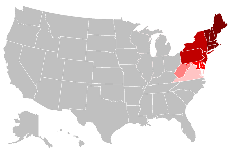
English: Map of the northeastern United States. The pink areas include states that are cited by fewer reliable sources as being included in the Northeast. The red areas are more frequently cited by reliable sources, and the dark red are the most commonly accepted as being included in the Northeast. |
| දිනය | |
| මූලාශ්රය | ස්වයං නිර්මාණයකි, File:BlankMap-USA-states.PNG |
| කර්තෘ | Grayshi, Roke, Maher-shalal-hashbaz |
බලපත්රීකරණය
I, මෙම කාර්යයේ ප්රකාශන අයිතිය දරන්නා,පහත බලපත්රය යටතේ එය ප්රකාශයට පත් කරනු ලබයි:
මෙම ගොනුව ක්රියේටිව් කොමන්ස් Attribution-Share Alike 3.0 Unported වරපත යටතේ අවසර ලබා ඇත.
- ඔබ නිදහස්:
- බෙදාහදා ගැනීමට – කාර්යය පිටපත් කිරීමට,බෙදා හැරීමට සහ සම්ප්රේෂණය කිරීමට
- නැවත සංකලනය කිරීමට – කාර්යයට අනුවර්තනය වීමට
- පහත කොන්දේසිවලට යටත්ව:
- attribution – වරපත වෙත බැඳියක්ද සපයමින් ඔබ විසින් සුදුසු කර්තෘභාරය ප්රදානය කල යුතු අතර, කිසියම් වෙනස්වීම් සිදුකලේ නම් එයද සඳහන් කල යුතු වෙයි. ඕනෑම සුදුසු ආකාරයට මෙය ඔබ විසින් සිදුකල හැකි මුත්, වරපත්දායකයා විසින් ඔබ හෝ ඔබගේ භාවිතය හෝ පිටසන් කරන බවට ඇඟවෙන ලෙසින් එය සිදු නොකල යුතු වෙයි.
- share alike – මෙම විෂය කාරණා භාවිතා කොට නැවත සංකලනය, ප්රතියෝජනය හෝ වැඩිදියුණුව කලේ නම්, ඉන්පසු ඔබගේ දායකත්වය ඔබ විසින් බෙදාහැරිය යුත්තේ මුල් වරපත හා සමාන හෝ සංගතික හෝ වරපතක් භාවිතා කරමිනි.

|
Free Software Foundation විසින් ප්රකාශිත GNU Free Documentation License බලපත්රයෙහි 1.2 හෝ ඊට අලුත් පිටපත්වල කොන්දේසිවලට යටත්ව මෙම ගොනුව පිටපත් කෙරුමට, නැවත බෙදාහාරුමට සහ/හෝ වෙනස් කෙරුමට අවසර දී ඇත; ඒ වෙනස් අංශ නොමැතිව, මුල් පිටු පෙළ නොමැතිව, පසු පිටු පෙළ නොමැතිවය. බලපත්රයේ පිටපතක් GNU Free Documentation License නම් අංශයේ දැක්වේ. |
ඔබට අභිමත වරපත තෝරාගත හැක.
ගොනු ඉතිහාසය
එම අවස්ථාවෙහිදී ගොනුව පැවැති ආකාරය නැරඹීමට දිනය/වේලාව මත ක්ලික් කරන්න.
| දිනය/වේලාව | කුඩා-රූපය | මාන | පරිශීලක | පරිකථනය | |
|---|---|---|---|---|---|
| වත්මන් | 23:19, 25 අප්රේල් 2018 | | 1,513 × 983 (46 කි.බ.) | Swarm | The Bureau of Prisons by itself is not sufficient to support Ohio being geographically classified as NE |
| 19:39, 6 පෙබරවාරි 2016 |  | 1,513 × 983 (31 කි.බ.) | Hoppingalong | Mean to revert back to this map by Maher-shalal-hashbaz | |
| 19:38, 6 පෙබරවාරි 2016 |  | 1,513 × 983 (36 කි.බ.) | Hoppingalong | Reverted to version as of 21:29, 5 May 2014 (UTC) - This is consistent with the article it illustrates. | |
| 03:54, 15 අගෝස්තු 2015 |  | 1,513 × 983 (46 කි.බ.) | Swarm | Removing Midwestern states. The source behind the inclusion and the weight given to the concept of these states being "Northeastern" are dubious at best and contradict the general body of reliable sources. | |
| 21:56, 5 මැයි 2014 |  | 1,513 × 983 (36 කි.බ.) | KenHigh | I keep trying to upload a new version and the new version appears in wiki properly, but when I upload it wiki shows the old version. The new version shows Wisconsin, Illinois, Michigan and Indiana in light pink, but when I upload it it shows them in gr... | |
| 21:32, 5 මැයි 2014 |  | 1,513 × 983 (36 කි.බ.) | KenHigh | Added new version of map showing Wisconsin, Illinois, Michigan and Indiana as states which are sometimes included in alternative definitions of the Northeast as stated and referenced in other parts of the article. | |
| 21:29, 5 මැයි 2014 |  | 1,513 × 983 (36 කි.බ.) | KenHigh | Added Wisconsin, Michigan, Illinois and Indiana in light pink to indicate that these states are also sometimes included in definitions of the Northeast as stated and referneced by other sections of this article. | |
| 14:55, 25 සැප්තැම්බර් 2013 |  | 1,513 × 983 (31 කි.බ.) | Maher-shalal-hashbaz | Added differentiation between states that are more commonly cited as Northeastern by reliable sources, and those which are less commonly cited as Northeastern by reliable sources. | |
| 23:23, 13 මාර්තු 2010 |  | 1,513 × 983 (43 කි.බ.) | Grayshi | fix red glow | |
| 23:20, 13 මාර්තු 2010 |  | 1,513 × 983 (69 කි.බ.) | Grayshi | cut the dark red boundary to be slightly more northern |
ගොනු භාවිතය
මෙම ගොනුව භාවිතා කරන නිසිදු පිටුවක් නොමැත.
ගෝලීය ගොනු භාවිතය
පහත දැක්වෙන අනෙකුත් විකියන් මගින් මෙම ගොනුව භාවිතා කරයි:
- ar.wikipedia.org හි භාවිතය
- ckb.wikipedia.org හි භාවිතය
- en.wikipedia.org හි භාවිතය
- fa.wikipedia.org හි භාවිතය
- it.wikipedia.org හි භාවිතය
- nl.wikipedia.org හි භාවිතය
- ur.wikipedia.org හි භාවිතය