
ගොනුව:USA Mass Cape Cod location map.svg

Size of this PNG preview of this SVG file: 560 × 420 පික්සල. අනෙකුත් විභේදනයන්: 320 × 240 පික්සල | 640 × 480 පික්සල | 1,024 × 768 පික්සල | 1,280 × 960 පික්සල | 2,560 × 1,920 පික්සල.
මුල් ගොනුව (SVG ගොනුව, නාමමාත්රිකව 560 × 420 පික්සල්, ගොනු විශාලත්වය: 264 කි.බ.)
සාරාංශය
| විස්තරය |
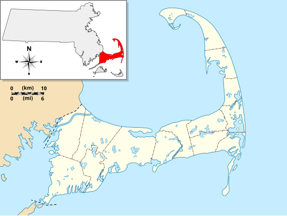
English: Location Map specific to (and zoomed to) Cape Cod, made specifically for the "WikiProject Massachusetts - Cape Cod and the Islands" on the English Wikipedia, but it is available to all.
For detailed instructions and several examples showing the various ways to use this file, see the documentation page at en:Module:Location map/data/USA Cape Cod. Specifications:
|
| දිනය | |
| මූලාශ්රය | ස්වයං නිර්මාණයකි |
| කර්තෘ | Grolltech |
| අනෙකුත් අනුවාදයන් |
This file was derived from: USA Massachusetts location map.svg: |
| SVG genesis |
බලපත්රීකරණය
මෙම කෘතියෙහි හිමිකම් අයිතීන් දරන්නා වන මම,පහත වරපත යටතේ එය ප්රකාශයට පත් කරමි:
මෙම ගොනුව ක්රියේටිව් කොමන්ස් Attribution-Share Alike 3.0 Unported වරපත යටතේ අවසර ලබා ඇත.
- ඔබ නිදහස්:
- බෙදාහදා ගැනීමට – කාර්යය පිටපත් කිරීමට,බෙදා හැරීමට සහ සම්ප්රේෂණය කිරීමට
- නැවත සංකලනය කිරීමට – කාර්යයට අනුවර්තනය වීමට
- පහත කොන්දේසිවලට යටත්ව:
- attribution – වරපත වෙත බැඳියක්ද සපයමින් ඔබ විසින් සුදුසු කර්තෘභාරය ප්රදානය කල යුතු අතර, කිසියම් වෙනස්වීම් සිදුකලේ නම් එයද සඳහන් කල යුතු වෙයි. ඕනෑම සුදුසු ආකාරයට මෙය ඔබ විසින් සිදුකල හැකි මුත්, වරපත්දායකයා විසින් ඔබ හෝ ඔබගේ භාවිතය හෝ පිටසන් කරන බවට ඇඟවෙන ලෙසින් එය සිදු නොකල යුතු වෙයි.
- share alike – මෙම විෂය කාරණා භාවිතා කොට නැවත සංකලනය, ප්රතියෝජනය හෝ වැඩිදියුණුව කලේ නම්, ඉන්පසු ඔබගේ දායකත්වය ඔබ විසින් බෙදාහැරිය යුත්තේ මුල් වරපත හා සමාන හෝ සංගතික හෝ වරපතක් භාවිතා කරමිනි.
ගොනු ඉතිහාසය
එම අවස්ථාවෙහිදී ගොනුව පැවැති ආකාරය නැරඹීමට දිනය/වේලාව මත ක්ලික් කරන්න.
| දිනය/වේලාව | කුඩා-රූපය | මාන | පරිශීලක | පරිකථනය | |
|---|---|---|---|---|---|
| වත්මන් | 11:25, 13 මැයි 2013 | | 560 × 420 (264 කි.බ.) | Grolltech | reshaped Monomoy; added overlay layers to facilitate reuse of this file |
| 22:45, 7 මැයි 2013 |  | 560 × 420 (189 කි.බ.) | Grolltech | further reduced thickness of town boundaries, land outlines | |
| 08:10, 6 මැයි 2013 |  | 560 × 420 (206 කි.බ.) | Grolltech | moved compass rose out of the way | |
| 17:39, 31 මැයි 2012 |  | 560 × 420 (205 කි.බ.) | Grolltech | 1) moved scale legend to the left edge, and 2) reduced thickness of town boundaries, land outlines, lakes and ponds. Both of these changes are intended lessen the impact on readability of pushpin labels. | |
| 17:21, 13 මැයි 2012 |  | 560 × 420 (206 කි.බ.) | Grolltech | added town boundaries | |
| 05:51, 13 මැයි 2012 |  | 560 × 420 (190 කි.බ.) | Grolltech | {{Information |Description ={{en|1=Locator Map for Cape Cod exclusively. Made for "Wikiproject Massachusetts - Cape Cod and the Islands". Equirectangular projection, N/S stretching 130.0 %. Geographic limits of the map: Northern boundary: 42.104... |
ගොනු භාවිතය
පහත දැක්වෙන පිටු 3 ක් විසින් මෙම ගොනුව භාවිතා කෙරෙයි:
ගෝලීය ගොනු භාවිතය
පහත දැක්වෙන අනෙකුත් විකියන් මගින් මෙම ගොනුව භාවිතා කරයි:
- ar.wikipedia.org හි භාවිතය
- azb.wikipedia.org හි භාවිතය
- ceb.wikipedia.org හි භාවිතය
- en.wikipedia.org හි භාවිතය
- Cape Cod
- Cape Cod Canal
- Provincetown Harbor
- Cape Cod Baseball League
- Eastham Windmill
- Sagamore Beach, Massachusetts
- Attaquin Beach
- Provincetown Historic District
- Race Point Light
- Center Methodist Church
- Provincetown Public Library (old)
- North Truro Air Force Station
- South Harwich, Massachusetts
- Hyannis Armory
- Louis Brandeis House
- Nauset Archeological District
- Ancient Burying Ground
- Chatham Windmill
- First Universalist Church (Provincetown, Massachusetts)
- Adams-Crocker-Fish House
- South Harwich Methodist Church
- Osterville Baptist Church
- Old Higgins Farm Windmill
- Universalist Society Meetinghouse
- Poor House and Methodist Cemetery
- Cove Burying Ground
- Bridge Road Cemetery
- Old Indian Meeting House
- Ahearn House and Summer House
- Josiah A. Ames House
- Atwood–Higgins Historic District
- Barnstable County Courthouse
- Avant House (Mashpee, Massachusetts)
- Capt. Rodney J. Baxter House
- George I. Briggs House
- Benjamin Baker Jr. House
- Capt. Seth Baker Jr. House
- Nathaniel Baker House
- Baxter Mill
- Lemuel B. Chase House
- Canary-Hartnett House
- Brewster Old King's Highway Historic District
- Thomas Bray Farm
මෙම ගොනුවේ තවත් ගෝලීය භාවිත බලන්න.