
ගොනුව:Sulawesi location map plain.svg

Size of this PNG preview of this SVG file: 475 × 599 පික්සල. අනෙකුත් විභේදනයන්: 190 × 240 පික්සල | 381 × 480 පික්සල | 609 × 768 පික්සල | 812 × 1,024 පික්සල | 1,624 × 2,048 පික්සල | 744 × 938 පික්සල.
මුල් ගොනුව (SVG ගොනුව, නාමමාත්රිකව 744 × 938 පික්සල්, ගොනු විශාලත්වය: 1,012 කි.බ.)
සාරාංශය
| Description |
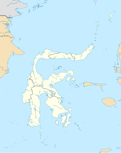
Bahasa Indonesia: Peta Pulau Sulawesi dengan batas administratif serta pulau-pulau di sekitarnya yang termasuk dalam provinsi yang ada di Sulawesi. Cakupan peta dibuat lebih besar untuk menampilkan Liukang Tangaya dan Masalima, Sulawesi Selatan, Bala Balakang, Sulawesi Barat, serta Miangas, Sulawesi Utara. Saya tidak menyertakan batas perairan karena tidak ada sumber resmi yang saya dapat temukan.
English: Plain map of the island of Sulawesi with administrative borders and surrounding islands belonged to the provinces in the island, including Liukang Tangaya and Masalima, South Sulawesi, Bala Balakang, West Sulawesi, and Miangas, North Sulawesi. I did not add maritime borders because I did not find any official sources in regards to it. |
|||||||||
| Creation | This W3C-unspecified vector image was created with Inkscape . This W3C-unspecified vector image was created with QGIS. |
|||||||||
| දිනය | ||||||||||
| මූලාශ්රය |
Bahasa Indonesia: Karya sendiri;
English: Own work;
|
|||||||||
| නිර්මාපකයා | ||||||||||
| අවසරය (මෙම ගොනුව නැවත භාවිතා කරමින්) |
Attribution like in #බලපත්රීකරණය below is required for including this image outside of Wikimedia projects. | |||||||||
| Geotemporal data | ||||||||||
| Spatial reference system | Equirectangular | |||||||||
| Heading |
 |
|||||||||
| Bounding box |
|
|||||||||
| අනෙකුත් අනුවාදයන් |
|
|||||||||

බලපත්රීකරණය
මෙම කෘතියෙහි හිමිකම් අයිතීන් දරන්නා වන මම,පහත වරපත යටතේ එය ප්රකාශයට පත් කරමි:
This file is licensed under the Creative Commons Attribution-Share Alike 4.0 International license.
Attribution: RXerself/Wikimedia Commons/CC BY-SA 4.0
- ඔබ නිදහස්:
- බෙදාහදා ගැනීමට – කාර්යය පිටපත් කිරීමට,බෙදා හැරීමට සහ සම්ප්රේෂණය කිරීමට
- නැවත සංකලනය කිරීමට – කාර්යයට අනුවර්තනය වීමට
- පහත කොන්දේසිවලට යටත්ව:
- attribution – වරපත වෙත බැඳියක්ද සපයමින් ඔබ විසින් සුදුසු කර්තෘභාරය ප්රදානය කල යුතු අතර, කිසියම් වෙනස්වීම් සිදුකලේ නම් එයද සඳහන් කල යුතු වෙයි. ඕනෑම සුදුසු ආකාරයට මෙය ඔබ විසින් සිදුකල හැකි මුත්, වරපත්දායකයා විසින් ඔබ හෝ ඔබගේ භාවිතය හෝ පිටසන් කරන බවට ඇඟවෙන ලෙසින් එය සිදු නොකල යුතු වෙයි.
- share alike – මෙම විෂය කාරණා භාවිතා කොට නැවත සංකලනය, ප්රතියෝජනය හෝ වැඩිදියුණුව කලේ නම්, ඉන්පසු ඔබගේ දායකත්වය ඔබ විසින් බෙදාහැරිය යුත්තේ මුල් වරපත හා සමාන හෝ සංගතික හෝ වරපතක් භාවිතා කරමිනි.
ගොනු ඉතිහාසය
එම අවස්ථාවෙහිදී ගොනුව පැවැති ආකාරය නැරඹීමට දිනය/වේලාව මත ක්ලික් කරන්න.
| දිනය/වේලාව | කුඩා-රූපය | මාන | පරිශීලක | පරිකථනය | |
|---|---|---|---|---|---|
| වත්මන් | 12:50, 27 ඔක්තෝබර් 2020 | | 744 × 938 (1,012 කි.බ.) | RXerself | Sonit |
| 05:43, 24 ඔක්තෝබර් 2020 |  | 744 × 938 (1,012 කි.බ.) | RXerself | Bala Balakang | |
| 23:10, 23 ඔක්තෝබර් 2020 |  | 744 × 938 (1,012 කි.බ.) | RXerself | {{Map |Description={{id|1=Peta Pulau Sulawesi dengan batas administratif serta pulau-pulau di sekitarnya yang termasuk dalam provinsi yang ada di Sulawesi. Cakupan peta dibuat lebih besar untuk menampilkan Liukang Tangaya dan Masalima, Sulawesi Selatan serta Miangas, Sulawesi Utara.}} {{en|1=Plain map of the island of Sulawesi with administrative borders and surrounding islands belonged to the provinces in the island, including Liukang Tangaya and Masalima, S... |
ගොනු භාවිතය
පහත දැක්වෙන පිටු 2 ක් විසින් මෙම ගොනුව භාවිතා කෙරෙයි:
ගෝලීය ගොනු භාවිතය
පහත දැක්වෙන අනෙකුත් විකියන් මගින් මෙම ගොනුව භාවිතා කරයි:
- en.wikipedia.org හි භාවිතය
- Sangir Island
- Makassar
- Poso
- Manado
- Buton
- Palu
- Banggai Regency
- Donggala Regency
- Luwuk
- Peleng
- Minahasa Peninsula
- East Peninsula, Sulawesi
- Southeast Peninsula, Sulawesi
- South Peninsula, Sulawesi
- Gulf of Tomini
- Kendari
- Mamuju (city)
- Parepare
- List of national parks of Indonesia
- Lagaligo Stadium
- Andi Mattalatta Stadium
- Sam Ratulangi International Airport
- Wakatobi Regency
- Muna Island
- User:Indon/sandbox
- Gorontalo (city)
- Maesa Stadium
- Ambang Stadium
- Adam Air Flight 574
- Bitung
- Jalaluddin Airport
- Haluoleo Airport
- Mutiara SIS Al-Jufrie Airport
- Sultan Hasanuddin International Airport
- Palopo
- Tomohon
- Selayar Islands Regency
- Selayar Island
- Baubau
- Kabaena
- Karakelong
- Wawonii Island
- Bogani Nani Wartabone National Park
- Rawa Aopa Watumohai National Park
- Majene
- Module:Location map/data/Indonesia Sulawesi/doc
- Watansoppeng
- Buol (town)
- Buol Regency
- Kasiguncu Airport
මෙම ගොනුවේ තවත් ගෝලීය භාවිත බලන්න.