
ගොනුව:South Korea Ulsan adm location map.svg

Size of this PNG preview of this SVG file: 600 × 600 පික්සල. අනෙකුත් විභේදනයන්: 240 × 240 පික්සල | 480 × 480 පික්සල | 768 × 768 පික්සල | 1,024 × 1,024 පික්සල | 2,048 × 2,048 පික්සල | 1,038 × 1,038 පික්සල.
මුල් ගොනුව (SVG ගොනුව, නාමමාත්රිකව 1,038 × 1,038 පික්සල්, ගොනු විශාලත්වය: 159 කි.බ.)
සාරාංශය
| විස්තරය |
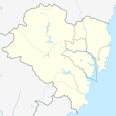
Deutsch: Positionskarte von Ulsan, Südkorea
English: Location map of Ulsan, South Korea
|
||||||||||||
| දිනය | |||||||||||||
| මූලාශ්රය |
Own work using: |
||||||||||||
| කර්තෘ | NordNordWest and OpenStreetMap contributors | ||||||||||||

|
This map has been made or improved in the German Kartenwerkstatt (Map Lab). You can propose maps to improve as well.
|
බලපත්රීකරණය
මෙම ගොනුව නිර්මාණශීලී පොදුවූවන් Attribution-Share Alike 2.0 Generic බලපත්රය යටතේ අවසර ලබා ඇත.
- ඔබ නිදහස්:
- බෙදාහදා ගැනීමට – කාර්යය පිටපත් කිරීමට,බෙදා හැරීමට සහ සම්ප්රේෂණය කිරීමට
- නැවත සංකලනය කිරීමට – කාර්යයට අනුවර්තනය වීමට
- පහත කොන්දේසිවලට යටත්ව:
- attribution – වරපත වෙත බැඳියක්ද සපයමින් ඔබ විසින් සුදුසු කර්තෘභාරය ප්රදානය කල යුතු අතර, කිසියම් වෙනස්වීම් සිදුකලේ නම් එයද සඳහන් කල යුතු වෙයි. ඕනෑම සුදුසු ආකාරයට මෙය ඔබ විසින් සිදුකල හැකි මුත්, වරපත්දායකයා විසින් ඔබ හෝ ඔබගේ භාවිතය හෝ පිටසන් කරන බවට ඇඟවෙන ලෙසින් එය සිදු නොකල යුතු වෙයි.
- share alike – මෙම විෂය කාරණා භාවිතා කොට නැවත සංකලනය, ප්රතියෝජනය හෝ වැඩිදියුණුව කලේ නම්, ඉන්පසු ඔබගේ දායකත්වය ඔබ විසින් බෙදාහැරිය යුත්තේ මුල් වරපත හා සමාන හෝ සංගතික හෝ වරපතක් භාවිතා කරමිනි.
ගොනු ඉතිහාසය
එම අවස්ථාවෙහිදී ගොනුව පැවැති ආකාරය නැරඹීමට දිනය/වේලාව මත ක්ලික් කරන්න.
| දිනය/වේලාව | කුඩා-රූපය | මාන | පරිශීලක | පරිකථනය | |
|---|---|---|---|---|---|
| වත්මන් | 18:28, 27 අගෝස්තු 2019 | | 1,038 × 1,038 (159 කි.බ.) | NordNordWest | == {{int:filedesc}} == {{Information |Description= {{de|1=Positionskarte von Ulsan, Südkorea}} {{en|1=Location map of Ulsan, South Korea}} {{Location map series N |stretching=– |top=35.7376583 |bottom=35.3130416 |left=128.9607861 |right=129.4840972}} |Source={{Own using}} * [http://www.openstreetmap.org OpenStreetMap] |Date=2019-08-27 |Author={{U|NordNordWest}} and OpenStreetMap contributors |Permission= |other_versions= }} {{Kartenwerkstatt}} == {{int:license-header}} == {{Cc-by-sa-2.0}} [... |
ගොනු භාවිතය
පහත දැක්වෙන පිටු 2 ක් විසින් මෙම ගොනුව භාවිතා කෙරෙයි:
ගෝලීය ගොනු භාවිතය
පහත දැක්වෙන අනෙකුත් විකියන් මගින් මෙම ගොනුව භාවිතා කරයි:
- de.wikipedia.org හි භාවිතය
- en.wikipedia.org හි භාවිතය
- fr.wikipedia.org හි භාවිතය
- he.wikipedia.org හි භාවිතය
- ja.wikipedia.org හි භාවිතය
- ko.wikipedia.org හි භාවිතය
- pt.wikipedia.org හි භාවිතය
- uz.wikipedia.org හි භාවිතය
- zh.wikipedia.org හි භාවිතය