
ගොනුව:Seto-Inland-Sea-Photo.jpg
මෙම පෙරදසුනෙහි විශාලත්වය: 800 × 565 පික්සල. අනෙකුත් විභේදනයන්: 320 × 226 පික්සල | 640 × 452 පික්සල | 1,024 × 723 පික්සල | 1,280 × 904 පික්සල | 1,700 × 1,200 පික්සල.
මුල් ගොනුව (1,700 × 1,200 පික්සල, ගොනු විශාලත්වය: 945 කි.බ., MIME ශෛලිය: image/jpeg)
සාරාංශය
| විස්තරය |
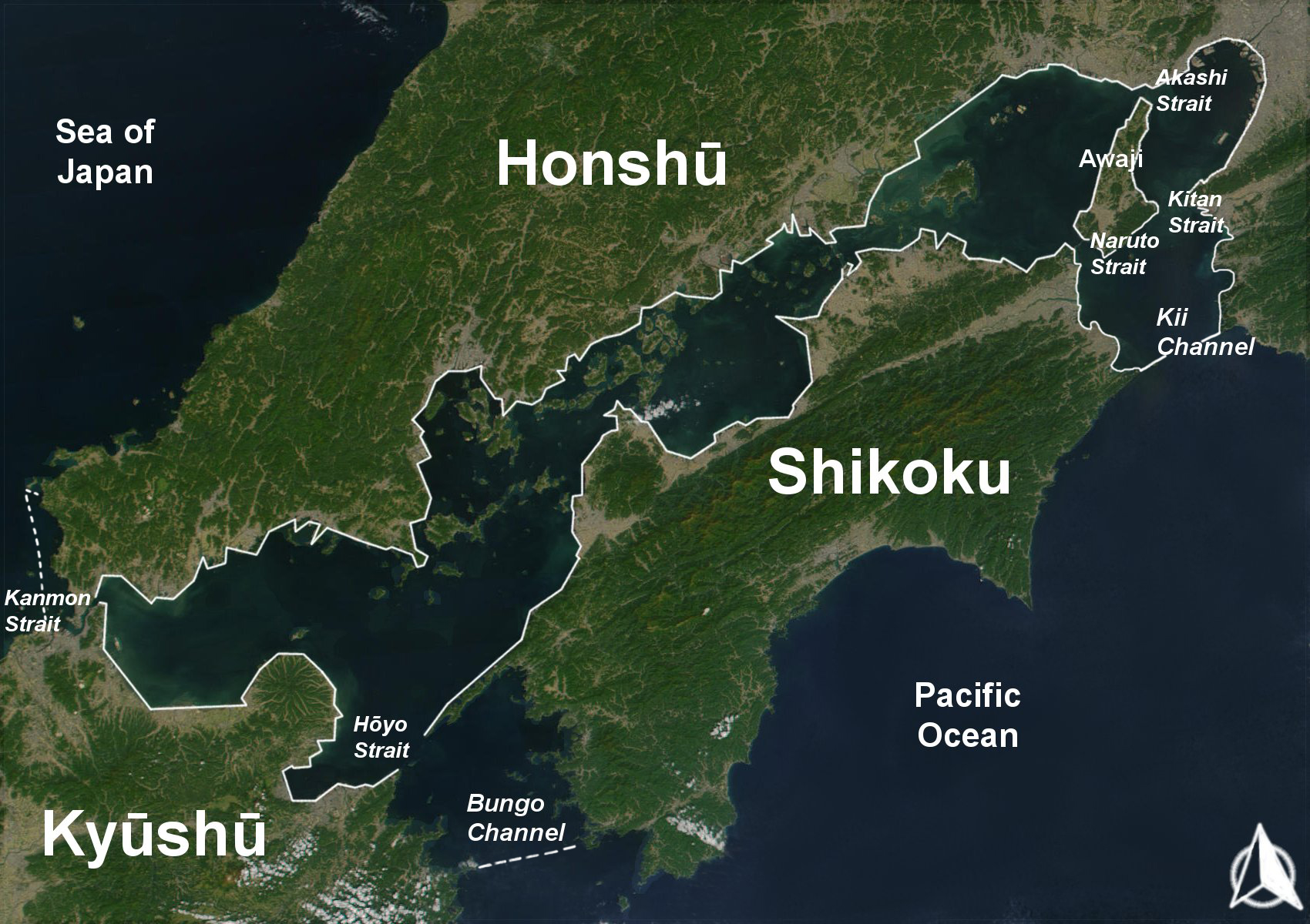
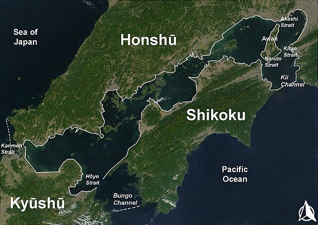
English: The Range of the Seto Inland Sea by the Territorial Sea Law (領海及び接続水域に関する法律) is 19,700 km2 (solid lines). Reference: Seto_Inland_Sea01.png . The Range of the Seto Inland Sea according to the Setouchi Law and the Setouchi Law Enforcement Order is 21,827 km2 (solid lines and dashed lines). Reference: Seto_Inland_Sea02.png.
Español: Mar interior de Seto. Extensión del Mar Interior |
| දිනය | |
| මූලාශ්රය | Based on a Public-Domain-Satellite photo of NASA |
| කර්තෘ | User:Guenny (Christian Günther) made this map of the Japanese Inland Sea (Setonaikai,瀬戸内海) for the German Wikipedia. de:Seto-Inlandsee. It's showing the Japanese islands surrounding the sea with the major straits and channels. Guenny is willing to do translations to other languages if needed, as well as corrections and enhancements. |

|
Free Software Foundation විසින් ප්රකාශිත GNU Free Documentation License බලපත්රයෙහි 1.2 හෝ ඊට අලුත් පිටපත්වල කොන්දේසිවලට යටත්ව මෙම ගොනුව පිටපත් කෙරුමට, නැවත බෙදාහාරුමට සහ/හෝ වෙනස් කෙරුමට අවසර දී ඇත; ඒ වෙනස් අංශ නොමැතිව, මුල් පිටු පෙළ නොමැතිව, පසු පිටු පෙළ නොමැතිවය. බලපත්රයේ පිටපතක් GNU Free Documentation License නම් අංශයේ දැක්වේ. |
| මෙම ගොනුව ක්රියේටිව් කොමන්ස් Attribution-Share Alike 3.0 Unported වරපත යටතේ අවසර ලබා ඇත. | ||
| ||
| GFDL බලපත්ර යාවත්කාල කෙරුමහි කොටසක් ලෙස මෙම ගොනුවට බලපත්ර ටැගය එක් කෙරිනි. |
ගොනු ඉතිහාසය
එම අවස්ථාවෙහිදී ගොනුව පැවැති ආකාරය නැරඹීමට දිනය/වේලාව මත ක්ලික් කරන්න.
| දිනය/වේලාව | කුඩා-රූපය | මාන | පරිශීලක | පරිකථනය | |
|---|---|---|---|---|---|
| වත්මන් | 10:43, 11 අගෝස්තු 2019 | | 1,700 × 1,200 (945 කි.බ.) | Artanisen | Added white solid lines for Kii Channel. |
| 10:32, 11 අගෝස්තු 2019 |  | 1,700 × 1,200 (941 කි.බ.) | Artanisen | Corrected white lines. The Range of the Seto Inland Sea by the Territorial Sea Law is 19,700 km2 (solid lines). Reference: Seto_Inland_Sea01.png . The Range of the Seto Inland Sea according to the Setouchi Law and the Setouchi Law Enforcement Order is 21,827 km2 (solid lines and dashed lines). Reference: Seto_Inland_Sea02.png . | |
| 19:18, 18 නොවැම්බර් 2004 |  | 1,700 × 1,200 (326 කි.බ.) | Christian Dobrinoff | {{GFDL}} |
ගොනු භාවිතය
පහත දැක්වෙන පිටුව විසින් මෙම ගොනුව භාවිතා කෙරෙයි:
ගෝලීය ගොනු භාවිතය
පහත දැක්වෙන අනෙකුත් විකියන් මගින් මෙම ගොනුව භාවිතා කරයි:
- an.wikipedia.org හි භාවිතය
- ar.wikipedia.org හි භාවිතය
- ast.wikipedia.org හි භාවිතය
- avk.wikipedia.org හි භාවිතය
- azb.wikipedia.org හි භාවිතය
- az.wikipedia.org හි භාවිතය
- bn.wikipedia.org හි භාවිතය
- br.wikipedia.org හි භාවිතය
- bs.wikipedia.org හි භාවිතය
- ca.wikipedia.org හි භාවිතය
- cs.wikipedia.org හි භාවිතය
- da.wikipedia.org හි භාවිතය
- de.wikipedia.org හි භාවිතය
- el.wikipedia.org හි භාවිතය
- en.wikipedia.org හි භාවිතය
- en.wiktionary.org හි භාවිතය
- eo.wikipedia.org හි භාවිතය
- es.wikipedia.org හි භාවිතය
- et.wikipedia.org හි භාවිතය
- eu.wikipedia.org හි භාවිතය
- fa.wikipedia.org හි භාවිතය
- fi.wikipedia.org හි භාවිතය
- fr.wikipedia.org හි භාවිතය
- fy.wikipedia.org හි භාවිතය
- gl.wikipedia.org හි භාවිතය
- he.wikipedia.org හි භාවිතය
- hr.wikipedia.org හි භාවිතය
- hu.wikipedia.org හි භාවිතය
- id.wikipedia.org හි භාවිතය
- is.wikipedia.org හි භාවිතය
- it.wikipedia.org හි භාවිතය
මෙම ගොනුවේ තවත් ගෝලීය භාවිත බලන්න.