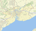
ගොනුව:Newport UK map roads and areas 2.svg

Page contents not supported in other languages.
විකිපීඩියා වෙතින්

මුල් ගොනුව(SVG ගොනුව, නාමමාත්‍රිකව 1,425 × 1,233 පික්සල්, ගොනු විශාලත්වය: 483 කි.බ.)

මෙම ගොනුව Wikimedia Commons වෙතින් වන අතර අනෙකුත් ව්‍යාපෘතීන් විසින්ද භාවිතා කල හැක. එහි ගොනු විස්තර පිටුව තුල අඩංගු විස්තර මෙහි පහත දැක්වෙයි.

විස්තරය

Map of Newport, UK with the following data shown:

  • Administrative borders
  • Coastline, lakes and rivers
  • Motorways and A-roads
  • Urban areas
  • Woodland areas

Equirectangular map projection on WGS 84 datum, with N/S stretched 160%

Geographic limits:

  • West: 3.15W
  • East: 2.78W
  • North: 51.67N
  • South: 51.47N
Map uses current convention of colours used for UK location maps on en.wikipedia.
දිනය
මූලාශ්‍රය Ordnance Survey OpenData. Administrative borders and coastline data from Boundary-Line product. Other data from Meridian 2 product.
කර්තෘ Nilfanion, created using Ordnance Survey data
අවසරය
(මෙම ගොනුව නැවත භාවිතා කරමින්)
w:en:Creative Commons
attribution
මෙම ගොනුව නිර්මාණශීලී පොදුවූවන් Attribution 3.0 Unported බලපත්‍රය යටතේ අවසර ලබා ඇත.
ඔබ නිදහස්:
  • බෙදාහදා ගැනීමට – කාර්යය පිටපත් කිරීමට,බෙදා හැරීමට සහ සම්ප්‍රේෂණය කිරීමට
  • නැවත සංකලනය කිරීමට – කාර්යයට අනුවර්තනය වීමට
පහත කොන්දේසිවලට යටත්ව:
  • attribution – වරපත වෙත බැඳියක්ද සපයමින් ඔබ විසින් සුදුසු කර්තෘභාරය ප්‍රදානය කල යුතු අතර, කිසියම් වෙනස්වීම් සිදුකලේ නම් එයද සඳහන් කල යුතු වෙයි. ඕනෑම සුදුසු ආකාරයට මෙය ඔබ විසින් සිදුකල හැකි මුත්, වරපත්දායකයා විසින් ඔබ හෝ ඔබගේ භාවිතය හෝ පිටසන් කරන බවට ඇඟවෙන ලෙසින් එය සිදු නොකල යුතු වෙයි.
අනෙකුත් අනුවාදයන් File:Newport UK map.svg - Blank map with administrative borders only, File:Newport UK map roads and areas 2.svg - Using WP wide location map conventions.

Captions

මෙම ගොනුව නිරූපණය කරන්නෙඑ කුමක්දැයි තනි පේළියේ පැහැදිළි කිරීමක් එක් කරන්න.

Items portrayed in this file

depicts ඉංග්‍රීසි

copyright status ඉංග්‍රීසි

copyrighted ඉංග්‍රීසි

copyright license ඉංග්‍රීසි

Creative Commons Attribution 3.0 Unported ඉංග්‍රීසි

inception ඉංග්‍රීසි

17 ජූලි 2010

ගොනු ඉතිහාසය

එම අවස්ථාවෙහිදී ගොනුව පැවැති ආකාරය නැරඹීමට දිනය/වේලාව මත ක්ලික් කරන්න.

දිනය/වේලාවකුඩා-රූපයමානපරිශීලකපරිකථනය
වත්මන්09:50, 28 ජූලි 2010 09:50, 28 ජූලි 2010වන විට අනුවාදය සඳහා කුඩා-රූපය1,425 × 1,233 (483 කි.බ.)Nilfanionbetter palette
08:36, 28 ජූලි 2010 08:36, 28 ජූලි 2010වන විට අනුවාදය සඳහා කුඩා-රූපය1,425 × 1,233 (483 කි.බ.)Nilfanion{{Information |Description=Map of Newport, UK with the following data shown: *Administrative borders *Coastline, lakes and rivers *Motorways and A-roads *Urban areas *Woodland areas Equirectangular map projection on WGS 84 datum, with N/S s

පහත දැක්වෙන පිටු 2 ක් විසින් මෙම ගොනුව භාවිතා කෙරෙයි:

ගෝලීය ගොනු භාවිතය

පහත දැක්වෙන අනෙකුත් විකියන් මගින් මෙම ගොනුව භාවිතා කරයි:

"https://si.wikipedia.org/wiki/ගොනුව:Newport_UK_map_roads_and_areas_2.svg" වෙතින් සම්ප්‍රවේශනය කෙරිණි