
ගොනුව:NTRoads.png
මෙම පෙරදසුනෙහි විශාලත්වය: 493 × 599 පික්සල. අනෙකුත් විභේදනයන්: 197 × 240 පික්සල | 395 × 480 පික්සල | 632 × 768 පික්සල | 842 × 1,024 පික්සල | 1,671 × 2,031 පික්සල.
මුල් ගොනුව (1,671 × 2,031 පික්සල, ගොනු විශාලත්වය: 379 කි.බ., MIME ශෛලිය: image/png)
සාරාංශය
| විස්තරය |
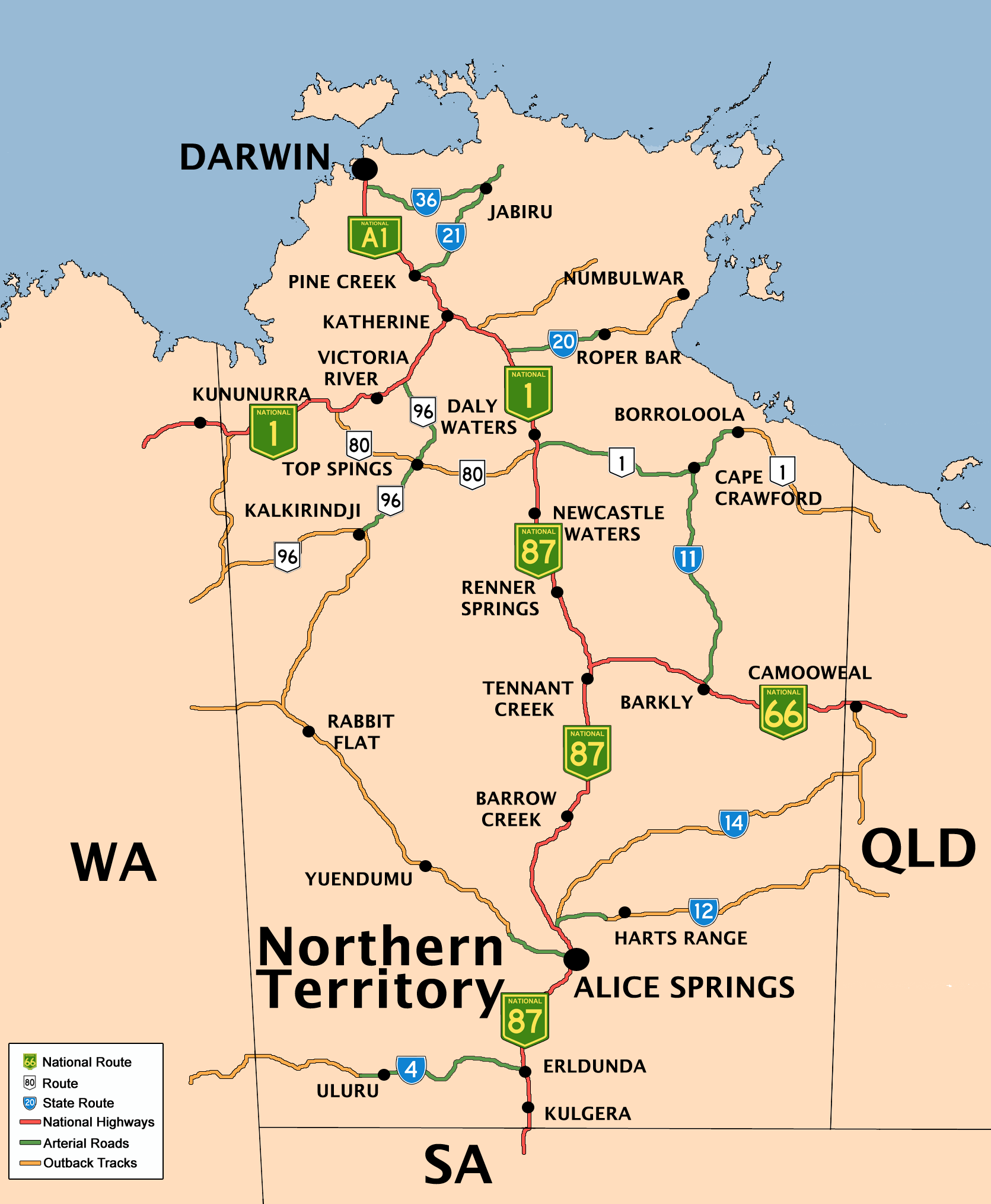
English: Created by Bidgee based upon on previous version by Mark and the previous version by Fikri. |
| දිනය | 7 දෙසැම්බර් 2004 (original upload date) |
| මූලාශ්රය | Transferred from en.wikipedia to Commons by Bidgee using CommonsHelper. |
| කර්තෘ | The original uploader was Fikri at ඉංග්රීසි විකිපීඩියා. |
බලපත්රීකරණය

|
Free Software Foundation විසින් ප්රකාශිත GNU Free Documentation License බලපත්රයෙහි 1.2 හෝ ඊට අලුත් පිටපත්වල කොන්දේසිවලට යටත්ව මෙම ගොනුව පිටපත් කෙරුමට, නැවත බෙදාහාරුමට සහ/හෝ වෙනස් කෙරුමට අවසර දී ඇත; ඒ වෙනස් අංශ නොමැතිව, මුල් පිටු පෙළ නොමැතිව, පසු පිටු පෙළ නොමැතිවය. බලපත්රයේ පිටපතක් GNU Free Documentation License නම් අංශයේ දැක්වේ. Subject to disclaimers. |
ප්රකෘති පැටවුම් ලොගය
The original description page was here. All following user names refer to en.wikipedia.
- 2008-06-15 06:23 Bidgee 1671×2031×8 (387634 bytes) Reverted to version as of 06:06, 15 June 2008
- 2008-06-15 06:18 Rom rulz424 401×487×8 (114087 bytes) Reverted to version as of 05:51, 15 June 2008
- 2008-06-15 06:06 Bidgee 1671×2031×8 (387634 bytes) Fixed. Next time inform me of any changes so it can be done that way the high res image stays how it should be
- 2008-06-15 05:51 Rom rulz424 401×487×8 (114087 bytes) National Highway Route 87, terminates at Daly Waters, not Katherine as the previous map suggests. Route 1 is the only continuous route throughout Australia and can be proven that National Highway Route 1 turns off at Daly Waters along the Carpentaria High
- 2008-06-14 14:08 Bidgee 1671×2031×8 (382374 bytes) Fixed Routes 66 and 1. Darwin is A1
- 2008-06-14 13:14 Rom rulz424 493×599×8 (150852 bytes) Route 66 and 1 both required the "NATIONAL" shield. It may show on Google Maps that there are square with no alphanumeric symbol beside it, but no Australian route exists with a square and a number only inside in green. If you refer to other references l
- 2008-06-14 09:32 Bidgee 1671×2031×8 (360953 bytes) Update routes based on Google Maps
- 2008-05-19 15:40 Bidgee 1671×2031×8 (1793646 bytes) New version based on previous versions by Mark and Fikri.
- 2007-04-24 16:28 Mark 744×1052×8 (82741 bytes) New (beautified) version of the original map by [[User:Fikri]].
- 2004-12-10 10:19 Clarkk 760×1009×4 (18240 bytes) crop image
- 2004-12-07 09:35 Fikri 810×1080×4 (17298 bytes) {{GFDL}}
ගොනු ඉතිහාසය
එම අවස්ථාවෙහිදී ගොනුව පැවැති ආකාරය නැරඹීමට දිනය/වේලාව මත ක්ලික් කරන්න.
| දිනය/වේලාව | කුඩා-රූපය | මාන | පරිශීලක | පරිකථනය | |
|---|---|---|---|---|---|
| වත්මන් | 13:21, 14 ජූලි 2008 | | 1,671 × 2,031 (379 කි.බ.) | Bidgee | {{Information |Description={{en|Created by Bidgee based upon on [http://upload.wikimedia.org/wikipedia/en/archive/3/32/20080519154026%21NTRoads.png previous version] by Mark and [http://upload.wikimedia.org/wikipedia/ |
ගොනු භාවිතය
පහත දැක්වෙන පිටු 3 ක් විසින් මෙම ගොනුව භාවිතා කෙරෙයි:
ගෝලීය ගොනු භාවිතය
පහත දැක්වෙන අනෙකුත් විකියන් මගින් මෙම ගොනුව භාවිතා කරයි:
- de.wikipedia.org හි භාවිතය
- de.wikivoyage.org හි භාවිතය
- en.wikipedia.org හි භාවිතය
- eo.wikipedia.org හි භාවිතය
- fr.wikipedia.org හි භාවිතය
- he.wikipedia.org හි භාවිතය
- he.wikivoyage.org හි භාවිතය
- hi.wikipedia.org හි භාවිතය
- it.wikipedia.org හි භාවිතය
- ja.wikipedia.org හි භාවිතය
- kn.wikipedia.org හි භාවිතය
- pl.wikipedia.org හි භාවිතය
- ru.wikipedia.org හි භාවිතය
- simple.wikipedia.org හි භාවිතය
- uz.wikipedia.org හි භාවිතය
- vls.wikipedia.org හි භාවිතය