
ගොනුව:NImap-CIA.jpg

මෙම පෙරදසුනෙහි විශාලත්වය: 727 × 599 පික්සල. අනෙකුත් විභේදනයන්: 291 × 240 පික්සල | 582 × 480 පික්සල | 932 × 768 පික්සල | 1,252 × 1,032 පික්සල.
මුල් ගොනුව (1,252 × 1,032 පික්සල, ගොනු විශාලත්වය: 274 කි.බ., MIME ශෛලිය: image/jpeg)
සාරාංශය
| විස්තරය |
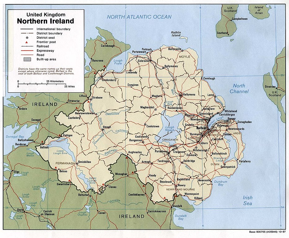
English: Map of Northern Ireland. |
| දිනය | |
| මූලාශ්රය | Northern Ireland (U.K) (Political) 1987 from Perry-Castañeda Library Map Collection: Europe Maps |
| කර්තෘ | U.S. Central Intelligence Agency |
| අවසරය (මෙම ගොනුව නැවත භාවිතා කරමින්) |
Public domain |
බලපත්රීකරණය
| This image is a work of a Central Intelligence Agency employee, taken or made as part of that person's official duties. As a Work of the United States Government, this image or media is in the public domain in the United States.
|

|
ගොනු ඉතිහාසය
එම අවස්ථාවෙහිදී ගොනුව පැවැති ආකාරය නැරඹීමට දිනය/වේලාව මත ක්ලික් කරන්න.
| දිනය/වේලාව | කුඩා-රූපය | මාන | පරිශීලක | පරිකථනය | |
|---|---|---|---|---|---|
| වත්මන් | 09:06, 11 ජනවාරි 2005 | | 1,252 × 1,032 (274 කි.බ.) | Hoshie | CIA map of Northern Ireland, from [http://www.lib.utexas.edu/maps/europe/northern_ireland_pol87.jpg]. |
ගොනු භාවිතය
පහත දැක්වෙන පිටු 3 ක් විසින් මෙම ගොනුව භාවිතා කෙරෙයි:
ගෝලීය ගොනු භාවිතය
පහත දැක්වෙන අනෙකුත් විකියන් මගින් මෙම ගොනුව භාවිතා කරයි:
- als.wikipedia.org හි භාවිතය
- bn.wikipedia.org හි භාවිතය
- ca.wikipedia.org හි භාවිතය
- cs.wikipedia.org හි භාවිතය
- cv.wikipedia.org හි භාවිතය
- de.wikipedia.org හි භාවිතය
- dsb.wikipedia.org හි භාවිතය
- el.wikipedia.org හි භාවිතය
- en.wikipedia.org හි භාවිතය
- es.wikipedia.org හි භාවිතය
- fa.wikipedia.org හි භාවිතය
- fi.wikipedia.org හි භාවිතය
- frr.wikipedia.org හි භාවිතය
- fr.wikipedia.org හි භාවිතය
- gu.wikipedia.org හි භාවිතය
- he.wikipedia.org හි භාවිතය
- id.wikipedia.org හි භාවිතය
- is.wikipedia.org හි භාවිතය
- it.wikipedia.org හි භාවිතය
- it.wikinews.org හි භාවිතය
- ja.wikipedia.org හි භාවිතය
- kn.wikipedia.org හි භාවිතය
- lfn.wikipedia.org හි භාවිතය
- mr.wikipedia.org හි භාවිතය
- nl.wikipedia.org හි භාවිතය
- os.wikipedia.org හි භාවිතය
- pt.wikipedia.org හි භාවිතය
- qu.wikipedia.org හි භාවිතය
- rmy.wikipedia.org හි භාවිතය
- sco.wikipedia.org හි භාවිතය
- sh.wikipedia.org හි භාවිතය
- simple.wikipedia.org හි භාවිතය
- sk.wikipedia.org හි භාවිතය
- sl.wikipedia.org හි භාවිතය
මෙම ගොනුවේ තවත් ගෝලීය භාවිත බලන්න.