
ගොනුව:Matabeleland South districts.png

මෙම පෙරදසුනෙහි විශාලත්වය: 776 × 600 පික්සල. අනෙකුත් විභේදනයන්: 311 × 240 පික්සල | 621 × 480 පික්සල | 994 × 768 පික්සල | 1,056 × 816 පික්සල.
මුල් ගොනුව (1,056 × 816 පික්සල, ගොනු විශාලත්වය: 37 කි.බ., MIME ශෛලිය: image/png)
සාරාංශය
| විස්තරය |
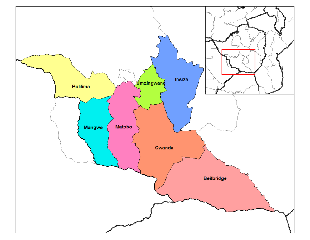
English: Map of the districts of Matabeleland South province of Zimbabwe. Created by Rarelibra 18:33, 28 September 2006 (UTC) for public domain use, using MapInfo Professional v8.5 and various mapping resources. |
| දිනය | 28 සැප්තැම්බර් 2006 (original upload date) |
| මූලාශ්රය | Transferred from en.wikipedia to Commons by Egs. |
| කර්තෘ | Rarelibra at ඉංග්රීසි විකිපීඩියා |
බලපත්රීකරණය
| මෙම කාර්යය එහි කර්තෘ, Rarelibra at ඉංග්රීසි විකිපීඩියා, විසින් public domain වෙත නිදහස් කර ඇත. එය ලෝක ව්යාප්තව අදාළ වේ. සමහර රටවල මෙය අනීතික විය හැකිය. එසේ වුවහොත්; නීතියෙන් යම් කොන්දේසියක් පනවා ඇති නම් හැරෙන්නට කිසිදු කොන්දේසියකින් තොරව ඕනෑම ප්රයෝජනයක් සඳහා මෙම කාර්යය භාවිතා කිරීමේ අයිතිය Rarelibra විසින් ලබා දෙයි. |
ප්රකෘති පැටවුම් ලොගය
The original description page was here. All following user names refer to en.wikipedia.
- 2006-09-28 18:33 Rarelibra 1056×816×8 (31578 bytes) Map of the districts of Matabeleland South province of Zimbabwe. Created by ~~~~ for public domain use, using MapInfo Professional v8.5 and various mapping resources.
ගොනු ඉතිහාසය
එම අවස්ථාවෙහිදී ගොනුව පැවැති ආකාරය නැරඹීමට දිනය/වේලාව මත ක්ලික් කරන්න.
| දිනය/වේලාව | කුඩා-රූපය | මාන | පරිශීලක | පරිකථනය | |
|---|---|---|---|---|---|
| වත්මන් | 15:44, 29 අගෝස්තු 2018 | | 1,056 × 816 (37 කි.බ.) | Gajmar | Bulilima and Mangwe Districts |
| 06:51, 26 අප්රේල් 2008 |  | 1,056 × 816 (31 කි.බ.) | File Upload Bot (Magnus Manske) | {{BotMoveToCommons|en.wikipedia}} {{Information |Description={{en|Map of the districts of Matabeleland South province of Zimbabwe. Created by Rarelibra 18:33, 28 September 2006 (UTC) for public domain use, using MapInfo Professiona |
ගොනු භාවිතය
පහත දැක්වෙන පිටුව විසින් මෙම ගොනුව භාවිතා කෙරෙයි:
ගෝලීය ගොනු භාවිතය
පහත දැක්වෙන අනෙකුත් විකියන් මගින් මෙම ගොනුව භාවිතා කරයි:
- bg.wikipedia.org හි භාවිතය
- ca.wikipedia.org හි භාවිතය
- de.wikipedia.org හි භාවිතය
- en.wikipedia.org හි භාවිතය
- es.wikipedia.org හි භාවිතය
- frr.wikipedia.org හි භාවිතය
- fr.wikipedia.org හි භාවිතය
- ha.wikipedia.org හි භාවිතය
- ig.wikipedia.org හි භාවිතය
- incubator.wikimedia.org හි භාවිතය
- it.wikipedia.org හි භාවිතය
- ja.wikipedia.org හි භාවිතය
- ka.wikipedia.org හි භාවිතය
- lt.wikipedia.org හි භාවිතය
- mrj.wikipedia.org හි භාවිතය
- nl.wikipedia.org හි භාවිතය
- pl.wikipedia.org හි භාවිතය
- pt.wikipedia.org හි භාවිතය
- ro.wikipedia.org හි භාවිතය
- ru.wikipedia.org හි භාවිතය
- sn.wikipedia.org හි භාවිතය
- tr.wikipedia.org හි භාවිතය
- ts.wikipedia.org හි භාවිතය
- uk.wikipedia.org හි භාවිතය
- ur.wikipedia.org හි භාවිතය
- vi.wikipedia.org හි භාවිතය
- www.wikidata.org හි භාවිතය
- yo.wikipedia.org හි භාවිතය
- zu.wikipedia.org හි භාවිතය
මෙම ගොනුවේ තවත් ගෝලීය භාවිත බලන්න.