
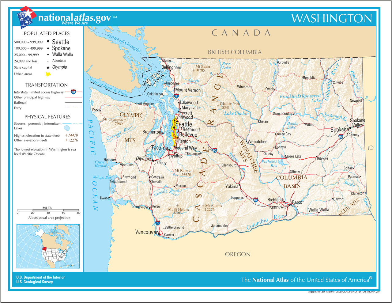
ගොනුව:Map of Washington NA.png
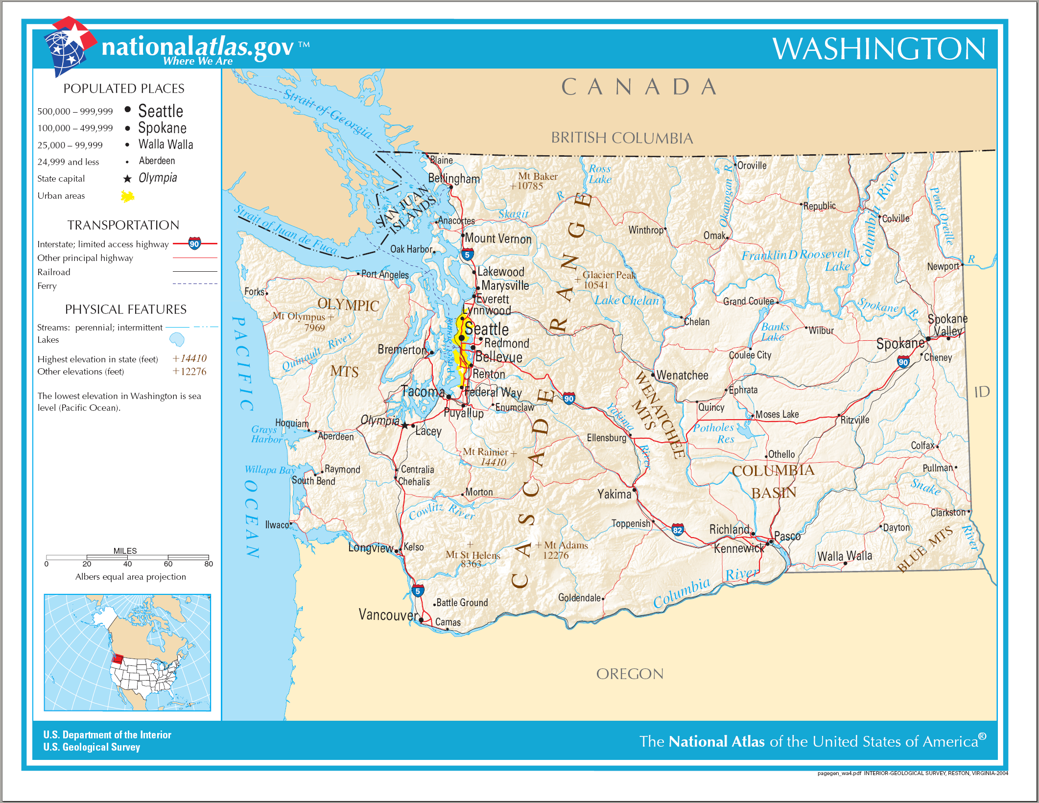
මෙම පෙරදසුනෙහි විශාලත්වය: 776 × 600 පික්සල. අනෙකුත් විභේදනයන්: 311 × 240 පික්සල | 621 × 480 පික්සල | 994 × 768 පික්සල | 1,280 × 989 පික්සල | 2,122 × 1,640 පික්සල.
මුල් ගොනුව (2,122 × 1,640 පික්සල, ගොනු විශාලත්වය: 2.39 මෙ.බ., MIME ශෛලිය: image/png)
සාරාංශය
| විස්තරය | Map of Washington (state). |
| දිනය | |
| මූලාශ්රය | National Atlas |
| කර්තෘ |
බලපත්රීකරණය
This map was obtained from an edition of the National Atlas of the United States. Like almost all works of the U.S. federal government, works from the National Atlas are in the public domain in the United States.
Online access: NationalAtlas.gov | 1970 print edition: Library of Congress, Perry-Castañeda Library
|
ගොනු ඉතිහාසය
එම අවස්ථාවෙහිදී ගොනුව පැවැති ආකාරය නැරඹීමට දිනය/වේලාව මත ක්ලික් කරන්න.
| දිනය/වේලාව | කුඩා-රූපය | මාන | පරිශීලක | පරිකථනය | |
|---|---|---|---|---|---|
| වත්මන් | 10:14, 15 අගෝස්තු 2006 | | 2,122 × 1,640 (2.39 මෙ.බ.) | Huebi~commonswiki | {{Information| |Description=Map of Washington |Source=[http://www.nationalatlas.gov National Atlas] }} Category:Maps of the United States Category:Maps of Washington {{PD-USGov-Atlas}} |
ගොනු භාවිතය
පහත දැක්වෙන පිටු 3 ක් විසින් මෙම ගොනුව භාවිතා කෙරෙයි:
ගෝලීය ගොනු භාවිතය
පහත දැක්වෙන අනෙකුත් විකියන් මගින් මෙම ගොනුව භාවිතා කරයි:
- ca.wikipedia.org හි භාවිතය
- de.wikipedia.org හි භාවිතය
- en.wikipedia.org හි භාවිතය
- es.wikipedia.org හි භාවිතය
- hsb.wikipedia.org හි භාවිතය
- hu.wikipedia.org හි භාවිතය
- ilo.wikipedia.org හි භාවිතය
- incubator.wikimedia.org හි භාවිතය
- is.wikipedia.org හි භාවිතය
- it.wikipedia.org හි භාවිතය
- kn.wikipedia.org හි භාවිතය
- mr.wikipedia.org හි භාවිතය
- ru.wikivoyage.org හි භාවිතය
- simple.wikipedia.org හි භාවිතය
- uz.wikipedia.org හි භාවිතය
- zea.wikipedia.org හි භාවිතය