
ගොනුව:Map of Blackford County, Indiana.svg

Size of this PNG preview of this SVG file: 600 × 600 පික්සල. අනෙකුත් විභේදනයන්: 240 × 240 පික්සල | 480 × 480 පික්සල | 768 × 768 පික්සල | 1,024 × 1,024 පික්සල | 2,048 × 2,048 පික්සල.
මුල් ගොනුව (SVG ගොනුව, නාමමාත්රිකව 768 × 768 පික්සල්, ගොනු විශාලත්වය: 508 කි.බ.)
සාරාංශය
| විස්තරය |
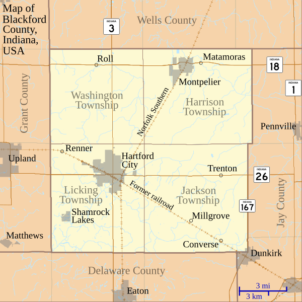
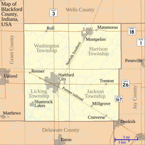
English: This is a map of Blackford County, Indiana, USA which shows settlements, county and township borders, and major transportation routes. |
| දිනය | |
| මූලාශ්රය | My own work, using custom-written MapScript applications with freely-available United States Census Bureau TIGER data |
| කර්තෘ | Omnedon |
බලපත්රීකරණය
| මම, මෙම කාර්යයේ ප්රතිරූපණ අයිති හිමිකරු, මෙම කාර්යය public domain වෙත නිදහස් කරමි. මෙය ලෝක ව්යාප්තව අදාළ වේ. සමහර රටවල මෙය අනීතික විය හැකිය. එසේ වුවහොත්; මම කිසිදු කොන්දේසියකින් තොරව,ඕනෑම අයෙකුට ඕනෑම කාර්යයක් සඳහා මෙය, නීතිමය බාධාවක් නොමැති වනතුරු, භාවිතා කිරීමේ අයිතිය ලබාදෙමි. |
ගොනු ඉතිහාසය
එම අවස්ථාවෙහිදී ගොනුව පැවැති ආකාරය නැරඹීමට දිනය/වේලාව මත ක්ලික් කරන්න.
| දිනය/වේලාව | කුඩා-රූපය | මාන | පරිශීලක | පරිකථනය | |
|---|---|---|---|---|---|
| වත්මන් | 22:49, 2 ජූලි 2011 | | 768 × 768 (508 කි.බ.) | Omnedon | == {{int:filedesc}} == {{Information |Description={{en|This is a map of Blackford County, Indiana, USA which shows settlements, county and township borders, and major transportation routes.}} |Source=My own work, using cus |
| 04:14, 20 ජූනි 2011 |  | 768 × 768 (506 කි.බ.) | Omnedon | == {{int:filedesc}} == {{Information |Description={{en|This is a map of Blackford County, Indiana, USA which includes incorporated settlement and township borders.}} |Source=My own work, using custom-written [http://www.ma | |
| 23:28, 17 පෙබරවාරි 2008 |  | 768 × 768 (29 කි.බ.) | Omnedon | {{Information |Description={{en|This is a map of Blackford County, Indiana, USA which shows settlements, townships, roads, railroads, and major rivers.}} |Source=My own work, using freely-available shape data and custom-written MapScript applications |Dat |
ගොනු භාවිතය
පහත දැක්වෙන පිටු 2 ක් විසින් මෙම ගොනුව භාවිතා කෙරෙයි:
ගෝලීය ගොනු භාවිතය
පහත දැක්වෙන අනෙකුත් විකියන් මගින් මෙම ගොනුව භාවිතා කරයි:
- ar.wikipedia.org හි භාවිතය
- ceb.wikipedia.org හි භාවිතය
- en.wikipedia.org හි භාවිතය
- Blackford County, Indiana
- Converse, Blackford County, Indiana
- Matamoras, Indiana
- Millgrove, Indiana
- Renner, Indiana
- Roll, Indiana
- Trenton, Indiana
- History of Hartford City, Indiana
- First Presbyterian Church (Hartford City, Indiana)
- Hartford City Courthouse Square Historic District
- Blackford County Courthouse
- Module:Location map/data/USA Indiana Blackford County/doc
- Montpelier Carnegie Library
- Module:Location map/data/USA Indiana Blackford County
- es.wikipedia.org හි භාවිතය
- fa.wikipedia.org හි භාවිතය
- fr.wikipedia.org හි භාවිතය
- kn.wikipedia.org හි භාවිතය
- nl.wikipedia.org හි භාවිතය
- ro.wikipedia.org හි භාවිතය
- tr.wikipedia.org හි භාවිතය
- war.wikipedia.org හි භාවිතය