
ගොනුව:Map Le Havre.jpg
මෙම පෙරදසුනෙහි විශාලත්වය: 603 × 599 පික්සල. අනෙකුත් විභේදනයන්: 242 × 240 පික්සල | 483 × 480 පික්සල | 773 × 768 පික්සල | 1,031 × 1,024 පික්සල | 1,980 × 1,967 පික්සල.
මුල් ගොනුව (1,980 × 1,967 පික්සල, ගොනු විශාලත්වය: 2.45 මෙ.බ., MIME ශෛලිය: image/jpeg)
සාරාංශය
| විස්තරය |
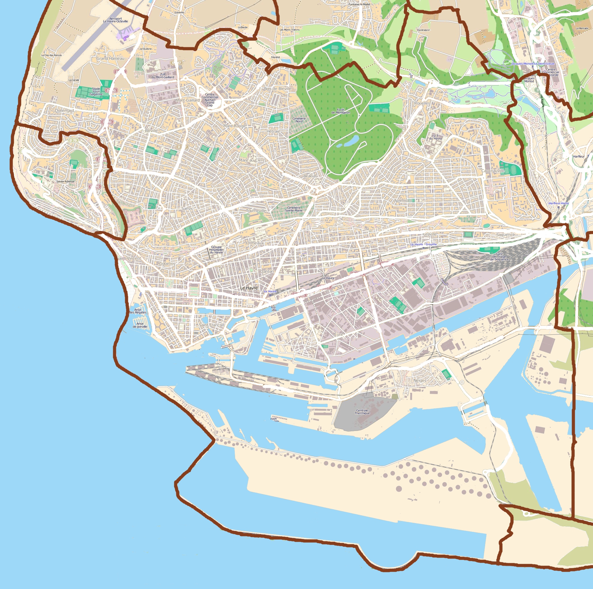
English: Map of Le Havre, France
Français : Carte du Havre, France |
||||||||||||
| දිනය | |||||||||||||
| මූලාශ්රය |
|
||||||||||||
| කර්තෘ | OpenStreetMap contributors |
බලපත්රීකරණය
මෙම ගොනුව ක්රියේටිව් කොමන්ස් Attribution-Share Alike 3.0 Unported වරපත යටතේ අවසර ලබා ඇත.
- ඔබ නිදහස්:
- බෙදාහදා ගැනීමට – කාර්යය පිටපත් කිරීමට,බෙදා හැරීමට සහ සම්ප්රේෂණය කිරීමට
- නැවත සංකලනය කිරීමට – කාර්යයට අනුවර්තනය වීමට
- පහත කොන්දේසිවලට යටත්ව:
- attribution – වරපත වෙත බැඳියක්ද සපයමින් ඔබ විසින් සුදුසු කර්තෘභාරය ප්රදානය කල යුතු අතර, කිසියම් වෙනස්වීම් සිදුකලේ නම් එයද සඳහන් කල යුතු වෙයි. ඕනෑම සුදුසු ආකාරයට මෙය ඔබ විසින් සිදුකල හැකි මුත්, වරපත්දායකයා විසින් ඔබ හෝ ඔබගේ භාවිතය හෝ පිටසන් කරන බවට ඇඟවෙන ලෙසින් එය සිදු නොකල යුතු වෙයි.
- share alike – මෙම විෂය කාරණා භාවිතා කොට නැවත සංකලනය, ප්රතියෝජනය හෝ වැඩිදියුණුව කලේ නම්, ඉන්පසු ඔබගේ දායකත්වය ඔබ විසින් බෙදාහැරිය යුත්තේ මුල් වරපත හා සමාන හෝ සංගතික හෝ වරපතක් භාවිතා කරමිනි.
ගොනු ඉතිහාසය
එම අවස්ථාවෙහිදී ගොනුව පැවැති ආකාරය නැරඹීමට දිනය/වේලාව මත ක්ලික් කරන්න.
| දිනය/වේලාව | කුඩා-රූපය | මාන | පරිශීලක | පරිකථනය | |
|---|---|---|---|---|---|
| වත්මන් | 08:57, 29 ජූලි 2011 | | 1,980 × 1,967 (2.45 මෙ.බ.) | XIIIfromTOKYO | {{Information |Description ={{en|1=Map of Le Havre, France}} {{fr|1=Carte du Havre, France}} |Source ={{openstreetmap}} |Author =OpenStreetMap contributors |Date =2011-07-29 |Permission = |other_versions = }} [[Category:L |
ගොනු භාවිතය
පහත දැක්වෙන පිටු 2 ක් විසින් මෙම ගොනුව භාවිතා කෙරෙයි:
ගෝලීය ගොනු භාවිතය
පහත දැක්වෙන අනෙකුත් විකියන් මගින් මෙම ගොනුව භාවිතා කරයි:
- ar.wikipedia.org හි භාවිතය
- ast.wikipedia.org හි භාවිතය
- azb.wikipedia.org හි භාවිතය
- ba.wikipedia.org හි භාවිතය
- ceb.wikipedia.org හි භාවිතය
- da.wikipedia.org හි භාවිතය
- en.wikipedia.org හි භාවිතය
- eo.wikipedia.org හි භාවිතය
- es.wikipedia.org හි භාවිතය
- fa.wikipedia.org හි භාවිතය
- fr.wikipedia.org හි භාවිතය
- Abbaye de Graville
- Aéroport du Havre-Octeville
- Centre-ville reconstruit du Havre
- Quartier Dollemard
- Stade Jules-Deschaseaux
- Quartier Caucriauville
- Lycée François-Ier (Le Havre)
- Quartier Sanvic
- Quartier Mont-Gaillard
- Quartier Anatole France-Danton
- Stade de la Cavée verte
- Muséum d'histoire naturelle du Havre
- Les Bains des Docks
- Tunnel Jenner
- Espace Coty
- Centrale thermique du Havre
- Jardins suspendus (Le Havre)
- Centre commercial La Lézarde
- Église Saint-François du Havre
- Chapelle Saint-Michel d'Ingouville
- Docks Vauban
- Musée Dubocage de Bléville
- Rouelles (Seine-Maritime)
- Stade Océane
- Modèle:Géolocalisation/Le Havre
- Stade Langstaff
- Square Saint-Roch
- Forêt de Montgeon
- Parc de Rouelles
- Jardins de la plage (Le Havre)
මෙම ගොනුවේ තවත් ගෝලීය භාවිත බලන්න.