
ගොනුව:Map-Latin America2.png
මෙයට ඉහල විසර්ජනයක් ලබාගත නොහැක.
Map-Latin_America2.png (390 × 450 පික්සල, ගොනු විශාලත්වය: 22 කි.බ., MIME ශෛලිය: image/png)

|
This linguistic map image could be re-created using vector graphics as an SVG file. This has several advantages; see Commons:Media for cleanup for more information. If an SVG form of this image is available, please upload it and afterwards replace this template with
{{vector version available|new image name}}.
It is recommended to name the SVG file “Map-Latin America2.svg”—then the template Vector version available (or Vva) does not need the new image name parameter. |
සාරාංශය
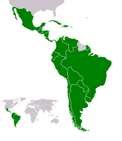
Español: Ubicación de América Latina

.
Map of en:Latin america. Thanks to write in the talk page if it's need to improve it. An alternative image is Image:Map-Latin America.png.
Map made from Image:BlankMap-World.png
බලපත්රීකරණය
මෙම කෘතියෙහි හිමිකම් අයිතීන් දරන්නා වන Yug නමැති මම, පහත වරපත යටතේ එය ප්රකාශයට පත් කරමි:
| මම, මෙම කාර්යයේ ප්රතිරූපණ අයිති හිමිකරු, මෙම කාර්යය public domain වෙත නිදහස් කරමි. මෙය ලෝක ව්යාප්තව අදාළ වේ. සමහර රටවල මෙය අනීතික විය හැකිය. එසේ වුවහොත්; මම කිසිදු කොන්දේසියකින් තොරව,ඕනෑම අයෙකුට ඕනෑම කාර්යයක් සඳහා මෙය, නීතිමය බාධාවක් නොමැති වනතුරු, භාවිතා කිරීමේ අයිතිය ලබාදෙමි. |
Atlas
This map should be added to the Wikimedia Atlas.
derivative works
Derivative works of this file: Map-Latin America2-2.png
ගොනු ඉතිහාසය
එම අවස්ථාවෙහිදී ගොනුව පැවැති ආකාරය නැරඹීමට දිනය/වේලාව මත ක්ලික් කරන්න.
| දිනය/වේලාව | කුඩා-රූපය | මාන | පරිශීලක | පරිකථනය | |
|---|---|---|---|---|---|
| වත්මන් | 22:23, 18 පෙබරවාරි 2018 | | 390 × 450 (22 කි.බ.) | Andrew J.Kurbiko | minor fix |
| 16:14, 20 මාර්තු 2011 |  | 390 × 450 (25 කි.බ.) | Philip Stevens | The Falkland Islands are not part of Latin America. | |
| 11:47, 7 දෙසැම්බර් 2008 |  | 390 × 450 (23 කි.බ.) | Osado | {{Information |Description= |Source= |Date= |Author= |Permission= |other_versions= }} | |
| 07:07, 20 ඔක්තෝබර් 2008 |  | 390 × 450 (21 කි.බ.) | Pruxo | malvinas part of latinoamerica | |
| 16:02, 15 ඔක්තෝබර් 2008 |  | 390 × 450 (21 කි.බ.) | Pruxo | mejora de "Imagen:Map-Latin America2.png", agregando islas en chile, agregando las Islas malvinas (o falklands) con color neutral, pasando la Guayana francesa junto con las demas guayanas (es territorio de ultramar frances, si fuera latinoamerica, quevec | |
| 21:55, 25 පෙබරවාරි 2006 |  | 390 × 450 (22 කි.බ.) | NoIdeaNick~commonswiki | Changed map to reflect the fact that Jamaica is not part of Latin America. | |
| 14:36, 19 ජනවාරි 2006 |  | 390 × 450 (23 කි.බ.) | NoIdeaNick~commonswiki | Just a little change to the color of Belize. | |
| 23:29, 21 දෙසැම්බර් 2005 |  | 390 × 450 (20 කි.බ.) | Yug | Zoom |
ගොනු භාවිතය
මෙම ගොනුව භාවිතා කරන නිසිදු පිටුවක් නොමැත.
ගෝලීය ගොනු භාවිතය
පහත දැක්වෙන අනෙකුත් විකියන් මගින් මෙම ගොනුව භාවිතා කරයි:
- af.wikipedia.org හි භාවිතය
- arc.wikipedia.org හි භාවිතය
- azb.wikipedia.org හි භාවිතය
- az.wikipedia.org හි භාවිතය
- br.wikipedia.org හි භාවිතය
- br.wiktionary.org හි භාවිතය
- ckb.wikipedia.org හි භාවිතය
- cv.wikipedia.org හි භාවිතය
- cy.wikipedia.org හි භාවිතය
- da.wikipedia.org හි භාවිතය
- de.wikipedia.org හි භාවිතය
- de.wiktionary.org හි භාවිතය
- en.wikipedia.org හි භාවිතය
- Latin America
- User:Dimadick
- Afro–Latin Americans
- User:Nivenus
- Wikipedia:Featured content/Portals
- User:Mikhajist
- User:Zdunne
- User:CatatonicStupor
- Wikipedia:Association of Hispanic and Latin American writers
- User:J. Finkelstein/Sandbox/LatinAmericaInfobox
- User:Es-arturus
- Etiquette in Latin America
- Water supply and sanitation in Latin America
- User:Adam sk
- Wikipedia:Articles for deletion/Log/2007 February 10
- Wikipedia:Articles for deletion/Latino Muslims
- Talk:Latin America/Archive 1
- User:Mvblair
- User:Tcd88
- User:Mikhajist/Userboxes
- User:Zero Gravity/Proposal
- User:Andreasmperu
- Wikipedia:Graphics Lab/Image workshop/Archive/May 2009
- User:Mosemamenti
- User:Mvblair/Userboxes/Latin American History
- User:Richie Boy 5
- User:Mosemamenti/Usuario:Mosemamenti
- User:Fcassia
- User:Saukkomies/My userboxes
- User:IANVS
- User:AKABumba
- User:Daguerrero
- User:Clarkp/Userboxes
- User:Hpav7
- User:Evanex
- User:Ixnix
මෙම ගොනුවේ තවත් ගෝලීය භාවිත බලන්න.