
ගොනුව:Luxembourg Grevenmacher location map.svg

Size of this PNG preview of this SVG file: 522 × 600 පික්සල. අනෙකුත් විභේදනයන්: 209 × 240 පික්සල | 418 × 480 පික්සල | 669 × 768 පික්සල | 891 × 1,024 පික්සල | 1,783 × 2,048 පික්සල | 1,150 × 1,321 පික්සල.
මුල් ගොනුව (SVG ගොනුව, නාමමාත්රිකව 1,150 × 1,321 පික්සල්, ගොනු විශාලත්වය: 267 කි.බ.)
සාරාංශය
| Description |
|
|||||||||
| දිනය | 1 September 2013 | |||||||||
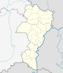
| මූලාශ්රය | You may find a page on the OpenStreetMap wiki page for Grevenmacher District | |||||||||
| නිර්මාපකයා |
NordNordWest
OpenStreetMap contributors |
|||||||||
| අවසරය (මෙම ගොනුව නැවත භාවිතා කරමින්) |
OpenStreetMap data is available under the Open Database License (details). Map tiles are licensed under the Creative Commons Attribution-ShareAlike 2.0 license (CC-BY-SA 2.0).
මෙම ගොනුව නිර්මාණශීලී පොදුවූවන් Attribution-Share Alike 2.0 Generic බලපත්රය යටතේ අවසර ලබා ඇත.
|
|||||||||
| Geotemporal data | ||||||||||
| Bounding box |
|
|||||||||
| Georeferencing | If inappropriate please set warp_status = skip to hide. | |||||||||
| අනෙකුත් අනුවාදයන් | ||||||||||

|
This map has been made or improved in the German Kartenwerkstatt (Map Lab). You can propose maps to improve as well.
|
ගොනු ඉතිහාසය
එම අවස්ථාවෙහිදී ගොනුව පැවැති ආකාරය නැරඹීමට දිනය/වේලාව මත ක්ලික් කරන්න.
| දිනය/වේලාව | කුඩා-රූපය | මාන | පරිශීලක | පරිකථනය | |
|---|---|---|---|---|---|
| වත්මන් | 20:21, 1 සැප්තැම්බර් 2013 | | 1,150 × 1,321 (267 කි.බ.) | NordNordWest | == {{int:filedesc}} == {{OpenStreetMap |name = Grevenmacher District |location = Grevenmacher District |description = {{de|Positionskarte für den Distrikt Grevenmacher, Luxemburg}}{{en|Locati... |
ගොනු භාවිතය
පහත දැක්වෙන පිටු 2 ක් විසින් මෙම ගොනුව භාවිතා කෙරෙයි:
ගෝලීය ගොනු භාවිතය
පහත දැක්වෙන අනෙකුත් විකියන් මගින් මෙම ගොනුව භාවිතා කරයි:
- ar.wikipedia.org හි භාවිතය
- ceb.wikipedia.org හි භාවිතය
- de.wikipedia.org හි භාවිතය
- en.wikipedia.org හි භාවිතය
- eo.wikipedia.org හි භාවිතය
- fa.wikipedia.org හි භාවිතය
- fr.wikipedia.org හි භාවිතය
- pl.wikipedia.org හි භාවිතය
- pl.wikibooks.org හි භාවිතය
- ru.wikipedia.org හි භාවිතය
- uz.wikipedia.org හි භාවිතය
- war.wikipedia.org හි භාවිතය