
ගොනුව:Lochaber UK location map.svg

Size of this PNG preview of this SVG file: 800 × 501 පික්සල. අනෙකුත් විභේදනයන්: 320 × 201 පික්සල | 640 × 401 පික්සල | 1,024 × 642 පික්සල | 1,280 × 802 පික්සල | 2,560 × 1,604 පික්සල | 1,425 × 893 පික්සල.
මුල් ගොනුව (SVG ගොනුව, නාමමාත්රිකව 1,425 × 893 පික්සල්, ගොනු විශාලත්වය: 2.39 මෙ.බ.)
| විස්තරය |
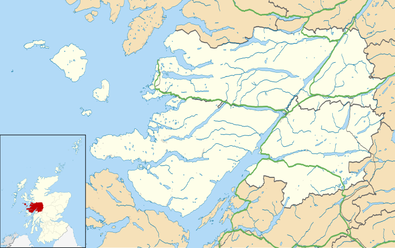
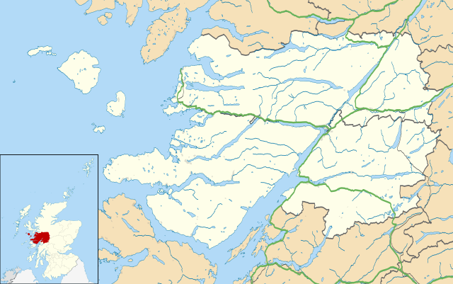
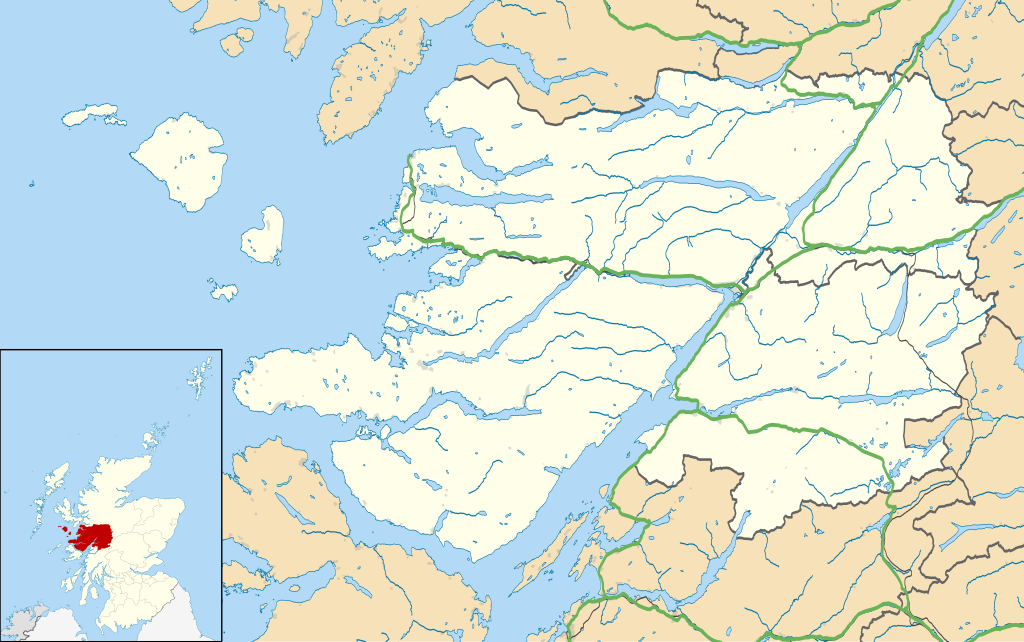
Map of the Lochaber ward management area, UK in 2011, with the following information shown:
Equirectangular map projection on WGS 84 datum, with N/S stretched 180% Geographic limits:
|
| දිනය | |
| මූලාශ්රය |
|
| කර්තෘ | Nilfanion, created using Ordnance Survey data |
| අවසරය (මෙම ගොනුව නැවත භාවිතා කරමින්) |
මෙම ගොනුව ක්රියේටිව් කොමන්ස් Attribution-Share Alike 3.0 Unported වරපත යටතේ අවසර ලබා ඇත. Attribution: Contains Ordnance Survey data © Crown copyright and database right
|
| අනෙකුත් අනුවාදයන් | File:Lochaber UK blank map.svg - Blank map |
ගොනු ඉතිහාසය
එම අවස්ථාවෙහිදී ගොනුව පැවැති ආකාරය නැරඹීමට දිනය/වේලාව මත ක්ලික් කරන්න.
| දිනය/වේලාව | කුඩා-රූපය | මාන | පරිශීලක | පරිකථනය | |
|---|---|---|---|---|---|
| වත්මන් | 14:23, 13 පෙබරවාරි 2011 | | 1,425 × 893 (2.39 මෙ.බ.) | Nilfanion | {{Information |Description=Map of the Lochaber ward management area, UK in 2011, with the following information shown: *Ward boundaries *Coastline, lakes and rivers *Roads and railways *Urban areas Equirectangular map projection on WGS 84 |
ගොනු භාවිතය
පහත දැක්වෙන පිටු 2 ක් විසින් මෙම ගොනුව භාවිතා කෙරෙයි:
ගෝලීය ගොනු භාවිතය
පහත දැක්වෙන අනෙකුත් විකියන් මගින් මෙම ගොනුව භාවිතා කරයි:
- ar.wikipedia.org හි භාවිතය
- ceb.wikipedia.org හි භාවිතය
- cs.wikipedia.org හි භාවිතය
- en.wikipedia.org හි භාවිතය
- Fort William, Scotland
- Back of Keppoch
- Glencoe, Highland
- Kinlochleven
- Mallaig
- Kilchoan
- Ballachulish
- Glenfinnan
- Onich
- Arisaig
- Morar
- Achnacarry
- Inverie
- Acharacle
- Achintee, Fort William
- Achosnich
- Achriabhach
- Portuairk
- Glenuig
- Laggan, Great Glen
- Morvern
- Banavie
- Lochailort
- Caol
- Aberchalder
- Achaphubuil
- Tarbet, Loch Nevis
- Glenborrodale
- Kilmory, Ardnamurchan
- Invergarry
- Blaich
- Achindarroch
- Alisary
- Ardery
- Ardmolich
- Ardtoe
- Bohuntine
- Bonnavoulin
- Ockle
- Bracora
- Bracorina
- Sanna, Ardnamurchan
- Belford Hospital
- Resipole
- Lochaline
- Roshven
- Achnasaul
මෙම ගොනුවේ තවත් ගෝලීය භාවිත බලන්න.