
ගොනුව:Lancashire UK location map.svg

Size of this PNG preview of this SVG file: 513 × 600 පික්සල. අනෙකුත් විභේදනයන්: 205 × 240 පික්සල | 410 × 480 පික්සල | 657 × 768 පික්සල | 876 × 1,024 පික්සල | 1,751 × 2,048 පික්සල | 1,116 × 1,305 පික්සල.
මුල් ගොනුව (SVG ගොනුව, නාමමාත්රිකව 1,116 × 1,305 පික්සල්, ගොනු විශාලත්වය: 2.3 මෙ.බ.)
| විස්තරය |
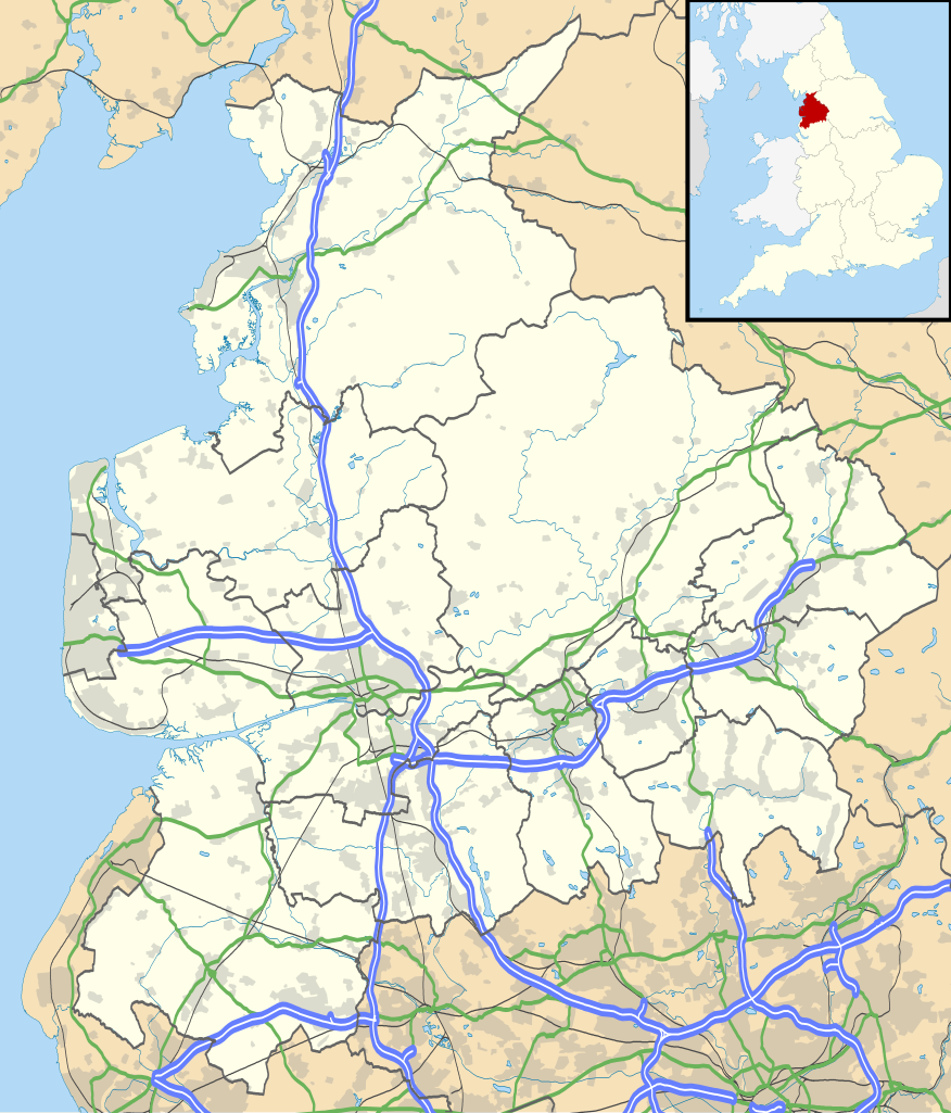
Map of Lancashire, UK with the following information shown:
Equirectangular map projection on WGS 84 datum, with N/S stretched 165% Geographic limits:
|
| දිනය | |
| මූලාශ්රය |
|
| කර්තෘ | Nilfanion, created using Ordnance Survey data |
| අවසරය (මෙම ගොනුව නැවත භාවිතා කරමින්) |
මෙම ගොනුව ක්රියේටිව් කොමන්ස් Attribution-Share Alike 3.0 Unported වරපත යටතේ අවසර ලබා ඇත. Attribution: Contains Ordnance Survey data © Crown copyright and database right
|
| අනෙකුත් අනුවාදයන් | File:Lancashire UK district map (blank).svg - Blank map |
.svg)
ගොනු ඉතිහාසය
එම අවස්ථාවෙහිදී ගොනුව පැවැති ආකාරය නැරඹීමට දිනය/වේලාව මත ක්ලික් කරන්න.
| දිනය/වේලාව | කුඩා-රූපය | මාන | පරිශීලක | පරිකථනය | |
|---|---|---|---|---|---|
| වත්මන් | 18:59, 26 සැප්තැම්බර් 2010 | | 1,116 × 1,305 (2.3 මෙ.බ.) | Nilfanion | {{Information |Description=Map of Lancashire, UK with the following information shown: *Administrative borders *Coastline, lakes and rivers *Roads and railways *Urban areas Equirectangular map projection on WGS 84 datum, with N/S stretch |
ගොනු භාවිතය
පහත දැක්වෙන පිටු 3 ක් විසින් මෙම ගොනුව භාවිතා කෙරෙයි:
ගෝලීය ගොනු භාවිතය
පහත දැක්වෙන අනෙකුත් විකියන් මගින් මෙම ගොනුව භාවිතා කරයි:
- ar.wikipedia.org හි භාවිතය
- bg.wikipedia.org හි භාවිතය
- ceb.wikipedia.org හි භාවිතය
- en.wikipedia.org හි භාවිතය
- Accrington
- Bacup
- Lancaster, Lancashire
- Preston, Lancashire
- Chorley
- Astley Hall, Chorley
- Blackpool
- Read, Lancashire
- Ormskirk
- Burnley
- Galgate
- Heysham
- Blackburn
- Barnoldswick
- Darwen
- Clitheroe
- Parbold
- Adlington, Lancashire
- Kirkham, Lancashire
- Lytham St Annes
- Longridge
- Poulton-le-Fylde
- Carnforth
- Reedley Hallows
- Up Holland
- Padiham
- Clayton-le-Moors
- Brierfield, Lancashire
- Oswaldtwistle
- Fleetwood
- Whalley, Lancashire
- Cleveleys
- Centre points of the United Kingdom
- Stonyhurst
- Bolton-le-Sands
- Haslingden
- River Wyre
- Lancashire Infantry Museum
- Higham, Lancashire
- Nelson, Lancashire
- Colne
- Wycoller
- Bleasdale
- Scarisbrick
- Knott End-on-Sea
- Great Altcar
- List of places in Lancashire
මෙම ගොනුවේ තවත් ගෝලීය භාවිත බලන්න.