
ගොනුව:Kuala Lumpur locator map.svg

Size of this PNG preview of this SVG file: 428 × 599 පික්සල. අනෙකුත් විභේදනයන්: 171 × 240 පික්සල | 343 × 480 පික්සල | 548 × 768 පික්සල | 731 × 1,024 පික්සල | 1,463 × 2,048 පික්සල | 500 × 700 පික්සල.
මුල් ගොනුව (SVG ගොනුව, නාමමාත්රිකව 500 × 700 පික්සල්, ගොනු විශාලත්වය: 306 කි.බ.)
සාරාංශය
| විස්තරය |
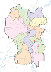
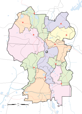
English: Map of w:Kuala Lumpur divided according to constituencies with highways (black) and major roads (red). City centre is marked by a Star Button and constituency towns marked by Red Buttons. Mukims (communes) are marked with dotted lines. |
||
| දිනය | |||
| මූලාශ්රය |
Own work by uploader for w:Wikipedia:WikiProject Malaysia/Cartography New boundaries were from SPR Malaysia and Tindak Malaysia (2018) |
||
| කර්තෘ |
|
||
| අනෙකුත් අනුවාදයන් | File:Kuala Lumpur subdistrict locator map.svg |
බලපත්රීකරණය
මෙම කෘතියෙහි හිමිකම් අයිතීන් දරන්නා වන මම,පහත වරපත යටතේ එය ප්රකාශයට පත් කරමි:
This file is licensed under the Creative Commons Attribution-Share Alike 4.0 International license.
- ඔබ නිදහස්:
- බෙදාහදා ගැනීමට – කාර්යය පිටපත් කිරීමට,බෙදා හැරීමට සහ සම්ප්රේෂණය කිරීමට
- නැවත සංකලනය කිරීමට – කාර්යයට අනුවර්තනය වීමට
- පහත කොන්දේසිවලට යටත්ව:
- attribution – වරපත වෙත බැඳියක්ද සපයමින් ඔබ විසින් සුදුසු කර්තෘභාරය ප්රදානය කල යුතු අතර, කිසියම් වෙනස්වීම් සිදුකලේ නම් එයද සඳහන් කල යුතු වෙයි. ඕනෑම සුදුසු ආකාරයට මෙය ඔබ විසින් සිදුකල හැකි මුත්, වරපත්දායකයා විසින් ඔබ හෝ ඔබගේ භාවිතය හෝ පිටසන් කරන බවට ඇඟවෙන ලෙසින් එය සිදු නොකල යුතු වෙයි.
- share alike – මෙම විෂය කාරණා භාවිතා කොට නැවත සංකලනය, ප්රතියෝජනය හෝ වැඩිදියුණුව කලේ නම්, ඉන්පසු ඔබගේ දායකත්වය ඔබ විසින් බෙදාහැරිය යුත්තේ මුල් වරපත හා සමාන හෝ සංගතික හෝ වරපතක් භාවිතා කරමිනි.
ගොනු ඉතිහාසය
එම අවස්ථාවෙහිදී ගොනුව පැවැති ආකාරය නැරඹීමට දිනය/වේලාව මත ක්ලික් කරන්න.
| දිනය/වේලාව | කුඩා-රූපය | මාන | පරිශීලක | පරිකථනය | |
|---|---|---|---|---|---|
| වත්මන් | 19:50, 29 අප්රේල් 2020 | | 500 × 700 (306 කි.බ.) | *angys* | add mukim boundaries |
| 19:18, 29 අප්රේල් 2020 |  | 500 × 700 (293 කි.බ.) | *angys* | Refined boundary, many thanks to Tindak Malaysia | |
| 18:00, 10 සැප්තැම්බර් 2018 |  | 500 × 700 (379 කි.බ.) | *angys* | new seat boundary from File:Selangor WPKL PRU14.svg | |
| 11:56, 22 ජූනි 2009 |  | 500 × 700 (307 කි.බ.) | Mdzafri | {{Information |Description={{en|1=Map of w:Kuala Lumpur divided according to constituencies with highways (black) and major roads (red). City centre is marked by a Star Button and constituency towns marked by Red Buttons.}} |Source=Own work by uploade |
ගොනු භාවිතය
පහත දැක්වෙන පිටු 2 ක් විසින් මෙම ගොනුව භාවිතා කෙරෙයි:
ගෝලීය ගොනු භාවිතය
පහත දැක්වෙන අනෙකුත් විකියන් මගින් මෙම ගොනුව භාවිතා කරයි:
- ar.wikipedia.org හි භාවිතය
- bjn.wikipedia.org හි භාවිතය
- ceb.wikipedia.org හි භාවිතය
- en.wikipedia.org හි භාවිතය
- Bangsar
- Taman Tun Dr Ismail
- RMAF Kuala Lumpur Air Base
- Wangsa Maju
- Islamic Arts Museum Malaysia
- User:Mdzafri
- Module:Location map/data/Malaysia Kuala Lumpur/doc
- Abdul Rahman Auf Mosque
- Kuala Lumpur Hospital
- Wikipedia:Meetup/Kuala Lumpur
- The Boulevard Hotel Kuala Lumpur
- Module:Location map/data/Malaysia Kuala Lumpur
- Wikipedia:Graphics Lab/Map workshop/Archive/Jun 2018
- 2019 Malaysia M3 League
- 2020 Malaysia M3 League
- Wikipedia:Graphics Lab/Map workshop/Archive/Feb 2020
- fa.wikipedia.org හි භාවිතය
- fr.wikipedia.org හි භාවිතය
- he.wikipedia.org හි භාවිතය
- id.wikipedia.org හි භාවිතය
- jv.wikipedia.org හි භාවිතය
- kn.wikipedia.org හි භාවිතය
- ms.wikipedia.org හි භාවිතය
- mt.wikipedia.org හි භාවිතය
- pl.wikipedia.org හි භාවිතය
මෙම ගොනුවේ තවත් ගෝලීය භාවිත බලන්න.