
ගොනුව:Katastrální mapa Prahy.PNG

මෙම පෙරදසුනෙහි විශාලත්වය: 800 × 585 පික්සල. අනෙකුත් විභේදනයන්: 320 × 234 පික්සල | 640 × 468 පික්සල | 1,024 × 749 පික්සල | 1,373 × 1,004 පික්සල.
මුල් ගොනුව (1,373 × 1,004 පික්සල, ගොනු විශාලත්වය: 87 කි.බ., MIME ශෛලිය: image/png)

|
This locator map image could be re-created using vector graphics as an SVG file. This has several advantages; see Commons:Media for cleanup for more information. If an SVG form of this image is available, please upload it and afterwards replace this template with
{{vector version available|new image name}}.
It is recommended to name the SVG file “Katastrální mapa Prahy.svg”—then the template Vector version available (or Vva) does not need the new image name parameter. |
සාරාංශය
| විස්තරය |
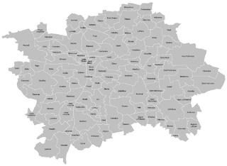
English: Cadastral map of Praha
Čeština: Katastrální mapa Prahy |
| දිනය | |
| මූලාශ්රය | ස්වයං නිර්මාණයකි |
| කර්තෘ | Mapového náložník |
| අනෙකුත් අනුවාදයන් | Derivative works of this file: Greater Prague.png |
බලපත්රීකරණය
| මම, මෙම කාර්යයේ ප්රතිරූපණ අයිති හිමිකරු, මෙම කාර්යය public domain වෙත නිදහස් කරමි. මෙය ලෝක ව්යාප්තව අදාළ වේ. සමහර රටවල මෙය අනීතික විය හැකිය. එසේ වුවහොත්; මම කිසිදු කොන්දේසියකින් තොරව,ඕනෑම අයෙකුට ඕනෑම කාර්යයක් සඳහා මෙය, නීතිමය බාධාවක් නොමැති වනතුරු, භාවිතා කිරීමේ අයිතිය ලබාදෙමි. |
ගොනු ඉතිහාසය
එම අවස්ථාවෙහිදී ගොනුව පැවැති ආකාරය නැරඹීමට දිනය/වේලාව මත ක්ලික් කරන්න.
| දිනය/වේලාව | කුඩා-රූපය | මාන | පරිශීලක | පරිකථනය | |
|---|---|---|---|---|---|
| වත්මන් | 17:04, 24 මාර්තු 2011 | | 1,373 × 1,004 (87 කි.බ.) | Mapového náložník | {{Information |Description ={{en|1=Cadastral map of Praha}} {{cs|1=Katastrální mapa Prahy}} |Source ={{own}} |Author =Mapového náložník |Date =23.3.2011 |Permission = |other_versions = |
ගොනු භාවිතය
පහත දැක්වෙන පිටු 2 ක් විසින් මෙම ගොනුව භාවිතා කෙරෙයි:
ගෝලීය ගොනු භාවිතය
පහත දැක්වෙන අනෙකුත් විකියන් මගින් මෙම ගොනුව භාවිතා කරයි:
- ar.wikipedia.org හි භාවිතය
- be-tarask.wikipedia.org හි භාවිතය
- ceb.wikipedia.org හි භාවිතය
- cs.wikipedia.org හි භාවිතය
- en.wikipedia.org හි භාවිතය
- Můstek
- Muzeum (Prague Metro)
- Náměstí Míru (Prague Metro)
- Zličín (Prague Metro)
- Nové Butovice (Prague Metro)
- Náměstí Republiky (Prague Metro)
- Florenc (Prague Metro)
- Českomoravská
- Ládví (Prague Metro)
- Kobylisy (Prague Metro)
- Nádraží Holešovice (Prague Metro)
- Vltavská (Prague Metro)
- Hlavní nádraží (Prague Metro)
- I. P. Pavlova (Prague Metro)
- Vyšehrad (Prague Metro)
- Pražského povstání (Prague Metro)
- Pankrác (Prague Metro)
- Budějovická (Prague Metro)
- Kačerov (Prague Metro)
- Roztyly (Prague Metro)
- Chodov (Prague Metro)
- Opatov (Prague Metro)
- Háje (Prague Metro)
- Football in the Czech Republic
- Střížkov (Prague Metro)
- Prosek (Prague Metro)
- Letňany (Prague Metro)
- Morzin Palace
- Module:Location map/data/Czech Republic Greater Prague/doc
- Straka Academy
- Prague–Kbely Airport
- Module:Location map/data/Czech Republic Greater Prague
- fa.wikipedia.org හි භාවිතය
- ja.wikipedia.org හි භාවිතය
- kn.wikipedia.org හි භාවිතය
- mk.wikipedia.org හි භාවිතය
- tr.wikipedia.org හි භාවිතය
මෙම ගොනුවේ තවත් ගෝලීය භාවිත බලන්න.