
ගොනුව:Jacksonville Urban Core.png

මෙම පෙරදසුනෙහි විශාලත්වය: 722 × 600 පික්සල. අනෙකුත් විභේදනයන්: 289 × 240 පික්සල | 578 × 480 පික්සල | 927 × 770 පික්සල.
මුල් ගොනුව (927 × 770 පික්සල, ගොනු විශාලත්වය: 515 කි.බ., MIME ශෛලිය: image/png)
සාරාංශය
| විස්තරය |
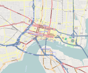
English: Central Jacksonville
Geographic limits of the map:
|
||
| දිනය | |||
| මූලාශ්රය | http://www.openstreetmap.org | ||
| කර්තෘ | OpenStreetMap contributors | ||
| අවසරය (මෙම ගොනුව නැවත භාවිතා කරමින්) |
Cartography is licensed as CC-BY-SA (http://www.openstreetmap.org/copyright) | ||
| අනෙකුත් අනුවාදයන් |
|

| This work contains information from OpenStreetMap, which is made available under the Open Database License (ODbL).
The ODbL does not require any particular license for maps produced from ODbL data. Prior to 1 August 2020, map tiles produced by the OpenStreetMap Foundation were licensed under the CC-BY-SA-2.0 license. Maps produced by other people may be subject to other licences. |
බලපත්රීකරණය
I, මෙම කාර්යයේ ප්රකාශන අයිතිය දරන්නා,පහත බලපත්රය යටතේ එය ප්රකාශයට පත් කරනු ලබයි:

|
Free Software Foundation විසින් ප්රකාශිත GNU Free Documentation License බලපත්රයෙහි 1.2 හෝ ඊට අලුත් පිටපත්වල කොන්දේසිවලට යටත්ව මෙම ගොනුව පිටපත් කෙරුමට, නැවත බෙදාහාරුමට සහ/හෝ වෙනස් කෙරුමට අවසර දී ඇත; ඒ වෙනස් අංශ නොමැතිව, මුල් පිටු පෙළ නොමැතිව, පසු පිටු පෙළ නොමැතිවය. බලපත්රයේ පිටපතක් GNU Free Documentation License නම් අංශයේ දැක්වේ. |
This file is licensed under the Creative Commons Attribution-Share Alike Attribution-Share Alike 4.0 International, 3.0 Unported, 2.5 Generic, 2.0 Generic and 1.0 Generic license.
- ඔබ නිදහස්:
- බෙදාහදා ගැනීමට – කාර්යය පිටපත් කිරීමට,බෙදා හැරීමට සහ සම්ප්රේෂණය කිරීමට
- නැවත සංකලනය කිරීමට – කාර්යයට අනුවර්තනය වීමට
- පහත කොන්දේසිවලට යටත්ව:
- attribution – වරපත වෙත බැඳියක්ද සපයමින් ඔබ විසින් සුදුසු කර්තෘභාරය ප්රදානය කල යුතු අතර, කිසියම් වෙනස්වීම් සිදුකලේ නම් එයද සඳහන් කල යුතු වෙයි. ඕනෑම සුදුසු ආකාරයට මෙය ඔබ විසින් සිදුකල හැකි මුත්, වරපත්දායකයා විසින් ඔබ හෝ ඔබගේ භාවිතය හෝ පිටසන් කරන බවට ඇඟවෙන ලෙසින් එය සිදු නොකල යුතු වෙයි.
- share alike – මෙම විෂය කාරණා භාවිතා කොට නැවත සංකලනය, ප්රතියෝජනය හෝ වැඩිදියුණුව කලේ නම්, ඉන්පසු ඔබගේ දායකත්වය ඔබ විසින් බෙදාහැරිය යුත්තේ මුල් වරපත හා සමාන හෝ සංගතික හෝ වරපතක් භාවිතා කරමිනි.
ඔබට අභිමත වරපත තෝරාගත හැක.
ගොනු ඉතිහාසය
එම අවස්ථාවෙහිදී ගොනුව පැවැති ආකාරය නැරඹීමට දිනය/වේලාව මත ක්ලික් කරන්න.
| දිනය/වේලාව | කුඩා-රූපය | මාන | පරිශීලක | පරිකථනය | |
|---|---|---|---|---|---|
| වත්මන් | 10:31, 5 මාර්තු 2013 | | 927 × 770 (515 කි.බ.) | Mathew105601 | {{Information |Description ={{en|1=Central Jacksonville Geographic limits of the map: * N: 30.3518° * S: 30.3018° * W: -81.6949° * E: -81.6252° }} |Source =http://www.openstreetmap.org |Author =OpenStreetMap contributors |Dat... |
ගොනු භාවිතය
පහත දැක්වෙන පිටු 2 ක් විසින් මෙම ගොනුව භාවිතා කෙරෙයි:
ගෝලීය ගොනු භාවිතය
පහත දැක්වෙන අනෙකුත් විකියන් මගින් මෙම ගොනුව භාවිතා කරයි:
- ar.wikipedia.org හි භාවිතය
- ceb.wikipedia.org හි භාවිතය
- en.wikipedia.org හි භාවිතය
- Brewster Hospital
- EverBank Stadium
- Springfield (Jacksonville)
- Bank of America Tower (Jacksonville)
- Downtown Jacksonville
- The Carling
- St. James Building
- Elks Club Building (Jacksonville)
- Old St. Andrew's Episcopal Church
- Greenleaf & Crosby Building
- Museum of Contemporary Art Jacksonville
- Cummer Museum of Art and Gardens
- Museum of Science and History
- Wells Fargo Center (Jacksonville)
- Jacksonville Fire Museum
- LaVilla
- Riverplace Tower
- Jessie Ball duPont Center
- Karpeles Manuscript Library Museum (Jacksonville)
- Eight Forty One
- Barnett National Bank Building
- Bryan Simpson United States Courthouse
- Jacksonville Maritime Museum
- TIAA Bank Center
- Sun-Ray Cinema
- Riverside and Avondale
- Module:Location map/data/United States Jacksonville/doc
- Brooklyn (Jacksonville)
- Southbank (Jacksonville)
- San Marco (Jacksonville)
- New Town (Jacksonville)
- VyStar Tower
- Two Prudential Plaza (Jacksonville)
- One Enterprise Center
- City Hall Annex (Jacksonville, Florida)
- CSX Transportation Building
- User:Mathew105601/Eastside
- Module:Location map/data/United States Jacksonville
- Hyatt Regency Jacksonville
- Jacksonville Landing shooting
- Edward Ball Building
- fr.wikipedia.org හි භාවිතය
මෙම ගොනුවේ තවත් ගෝලීය භාවිත බලන්න.