
ගොනුව:Glasgow UK location map.svg

Size of this PNG preview of this SVG file: 588 × 600 පික්සල. අනෙකුත් විභේදනයන්: 235 × 240 පික්සල | 471 × 480 පික්සල | 753 × 768 පික්සල | 1,004 × 1,024 පික්සල | 2,008 × 2,048 පික්සල | 1,357 × 1,384 පික්සල.
මුල් ගොනුව (SVG ගොනුව, නාමමාත්රිකව 1,357 × 1,384 පික්සල්, ගොනු විශාලත්වය: 1,006 කි.බ.)
| විස්තරය |
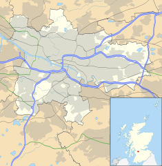
Blank map of Glasgow, UK with the following information shown:
Equirectangular map projection on WGS 84 datum, with N/S stretched 175% Geographic limits:
|
| දිනය | |
| මූලාශ්රය |
|
| කර්තෘ | Nilfanion, created using Ordnance Survey data |
| අවසරය (මෙම ගොනුව නැවත භාවිතා කරමින්) |
මෙම ගොනුව ක්රියේටිව් කොමන්ස් Attribution-Share Alike 3.0 Unported වරපත යටතේ අවසර ලබා ඇත. Attribution: Contains Ordnance Survey data © Crown copyright and database right
|
| අනෙකුත් අනුවාදයන් | File:Glasgow UK blank map.svg - Blank map |
ගොනු ඉතිහාසය
එම අවස්ථාවෙහිදී ගොනුව පැවැති ආකාරය නැරඹීමට දිනය/වේලාව මත ක්ලික් කරන්න.
| දිනය/වේලාව | කුඩා-රූපය | මාන | පරිශීලක | පරිකථනය | |
|---|---|---|---|---|---|
| වත්මන් | 17:24, 6 පෙබරවාරි 2012 | | 1,357 × 1,384 (1,006 කි.බ.) | Jheald | Updated for M80 and M74 (hand-edited in with Inkscape, tracing a screengrab from OpenStreetmap). |
| 20:15, 26 සැප්තැම්බර් 2010 |  | 1,357 × 1,384 (1,002 කි.බ.) | Nilfanion | {{Information |Description=Blank map of Glasgow, UK with the following information shown: *Administrative borders *Coastline, lakes and rivers *Roads and railways *Urban areas Equirectangular map projection on WGS 84 datum, with N/S stretch |
ගොනු භාවිතය
පහත දැක්වෙන පිටු 2 ක් විසින් මෙම ගොනුව භාවිතා කෙරෙයි:
ගෝලීය ගොනු භාවිතය
පහත දැක්වෙන අනෙකුත් විකියන් මගින් මෙම ගොනුව භාවිතා කරයි:
- ar.wikipedia.org හි භාවිතය
- azb.wikipedia.org හි භාවිතය
- az.wikipedia.org හි භාවිතය
- ban.wikipedia.org හි භාවිතය
- bg.wikipedia.org හි භාවිතය
- ceb.wikipedia.org හි භාවිතය
- de.wikipedia.org හි භාවිතය
- Ibrox Stadium
- Hampden Park
- Celtic Park
- Hamilton Crescent
- Firhill Stadium
- Emirates Arena
- Ibrox Park
- OVO Hydro
- Vorlage:Positionskarte Schottland Glasgow
- Scotstoun Stadium
- Glasgow City Heliport
- Springvale Park
- Cathkin Park (1872)
- Hampden Park (1873)
- Cathkin Park (1884)
- Barrowfield Park
- Hyde Park (Glasgow)
- Braehead Park
- Lesser Hampden
- en.wikipedia.org හි භාවිතය
මෙම ගොනුවේ තවත් ගෝලීය භාවිත බලන්න.