
ගොනුව:España-Canarias-loc.svg

Size of this PNG preview of this SVG file: 512 × 462 පික්සල. අනෙකුත් විභේදනයන්: 266 × 240 පික්සල | 532 × 480 පික්සල | 851 × 768 පික්සල | 1,135 × 1,024 පික්සල | 2,270 × 2,048 පික්සල.
මුල් ගොනුව (SVG ගොනුව, නාමමාත්රිකව 512 × 462 පික්සල්, ගොනු විශාලත්වය: 919 කි.බ.)
සාරාංශය
| විස්තරය |
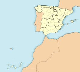
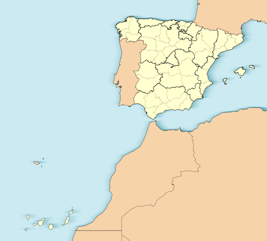
English: Location map of Spain with the Canary Islands
Equirectangular projection, N/S stretching 130 %. Geographic limits of the map:
Español: Mapa de localización de España con la Islas Canarias
Proyección equirrectangular (cilíndrica equidistante), N/S estirada 130 %. Límites geográficos del mapa:
|
|
| දිනය | ||
| මූලාශ්රය | Own work based on: EspañaLoc.svg | |
| කර්තෘ | Miguillen | |
| SVG genesis | This W3C-invalid locator map was created with Adobe Illustrator.
|
බලපත්රීකරණය
මෙම කෘතියෙහි හිමිකම් අයිතීන් දරන්නා වන Miguillen නමැති මම, පහත වරපත යටතේ එය ප්රකාශයට පත් කරමි:
මෙම ගොනුව ක්රියේටිව් කොමන්ස් Attribution-Share Alike 3.0 Unported වරපත යටතේ අවසර ලබා ඇත.
Attribution: Miguillen
- ඔබ නිදහස්:
- බෙදාහදා ගැනීමට – කාර්යය පිටපත් කිරීමට,බෙදා හැරීමට සහ සම්ප්රේෂණය කිරීමට
- නැවත සංකලනය කිරීමට – කාර්යයට අනුවර්තනය වීමට
- පහත කොන්දේසිවලට යටත්ව:
- attribution – වරපත වෙත බැඳියක්ද සපයමින් ඔබ විසින් සුදුසු කර්තෘභාරය ප්රදානය කල යුතු අතර, කිසියම් වෙනස්වීම් සිදුකලේ නම් එයද සඳහන් කල යුතු වෙයි. ඕනෑම සුදුසු ආකාරයට මෙය ඔබ විසින් සිදුකල හැකි මුත්, වරපත්දායකයා විසින් ඔබ හෝ ඔබගේ භාවිතය හෝ පිටසන් කරන බවට ඇඟවෙන ලෙසින් එය සිදු නොකල යුතු වෙයි.
- share alike – මෙම විෂය කාරණා භාවිතා කොට නැවත සංකලනය, ප්රතියෝජනය හෝ වැඩිදියුණුව කලේ නම්, ඉන්පසු ඔබගේ දායකත්වය ඔබ විසින් බෙදාහැරිය යුත්තේ මුල් වරපත හා සමාන හෝ සංගතික හෝ වරපතක් භාවිතා කරමිනි.
ගොනු ඉතිහාසය
එම අවස්ථාවෙහිදී ගොනුව පැවැති ආකාරය නැරඹීමට දිනය/වේලාව මත ක්ලික් කරන්න.
| දිනය/වේලාව | කුඩා-රූපය | මාන | පරිශීලක | පරිකථනය | |
|---|---|---|---|---|---|
| වත්මන් | 15:31, 3 ජූනි 2012 | | 512 × 462 (919 කි.බ.) | Miguillen | Quito isla inexistente en el golfo de Cádiz y retiro margen externo. |
| 12:45, 18 නොවැම්බර් 2010 |  | 512 × 462 (932 කි.බ.) | Miguillen | me he equivocado de archivo | |
| 12:44, 18 නොවැම්බර් 2010 |  | 512 × 398 (2.82 මෙ.බ.) | Miguillen | == {{int:filedesc}} == {{Information |Description={{en|Location map of Spain}} Equirectangular projection, N/S stretching 130 %. Geographic limits of the map: * N: ° N * S: ° N * W: ° O * E: ° O {{es|Mapa de localización de [[:es:E |
ගොනු භාවිතය
පහත දැක්වෙන පිටු 2 ක් විසින් මෙම ගොනුව භාවිතා කෙරෙයි:
ගෝලීය ගොනු භාවිතය
පහත දැක්වෙන අනෙකුත් විකියන් මගින් මෙම ගොනුව භාවිතා කරයි:
- ar.wikipedia.org හි භාවිතය
- ast.wikipedia.org හි භාවිතය
- Mallorca
- Península Ibérica
- Bermellar
- Saldeana
- Estorga
- Santiago de Compostela
- Melilla
- Ceuta
- Ríu Duero
- Ríu Esla
- Aldeadávila de la Ribera
- Masueco
- Vilvestre
- Lumbrales
- Pereña de la Ribera
- Bermillo de Sayago
- Fermoselle
- Alcañices
- Ciudad Rodrigo
- Salamanca
- Llión
- Zamora
- Albacete
- A Ponte de Domingos Flórez
- Alija del Infantado
- Toral de los Vados
- Santovenia de la Valdoncina
- Acebedo (Lleón)
- Algadefe
- Almanza
- Castrocontrigo
- Ríu Eria
- Teleno
- Ozaniego
- La Nora del Río
- Navianos de la Vega
- Cabrera de Almanza
- Calaveras de Abajo
- Calaveras de Arriba
- Castromudarra
- Espinosa de Almanza
- La Vega de Almanza
- Toreno
- Barcelona
- Ríu Órbigu
- Ríu Tuerto
- Zaragoza
- Logroño
- Ríu Deva
මෙම ගොනුවේ තවත් ගෝලීය භාවිත බලන්න.