
ගොනුව:Elstree and Borehamwood parish UK location map.svg

Size of this PNG preview of this SVG file: 398 × 400 පික්සල. අනෙකුත් විභේදනයන්: 239 × 240 පික්සල | 478 × 480 පික්සල | 764 × 768 පික්සල | 1,019 × 1,024 පික්සල | 2,038 × 2,048 පික්සල.
මුල් ගොනුව (SVG ගොනුව, නාමමාත්රිකව 398 × 400 පික්සල්, ගොනු විශාලත්වය: 1.73 මෙ.බ.)
සාරාංශය
| විස්තරය |
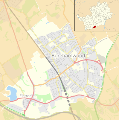
English: Location map of the civil parish of Elstree and Borehamwood, Hertfordshire, England, in 2022, showing roads, railways, rivers and built-up areas. Inset highlights Elstree and Borehamwood among all the civil parishes of Hertfordshire.
Equirectangular map projection on WGS 84 datum, with N/S stretched 160%.
Other road
Railway
Woodland
Built-up area |
| දිනය | |
| මූලාශ්රය |
This file was derived from : |
| කර්තෘ |
|
.svg)
බලපත්රීකරණය
| This work contains information from OpenStreetMap, which is made available under the Open Database License (ODbL).
The ODbL does not require any particular license for maps produced from ODbL data. Prior to 1 August 2020, map tiles produced by the OpenStreetMap Foundation were licensed under the CC-BY-SA-2.0 license. Maps produced by other people may be subject to other licences. |
This file is licensed under the Creative Commons Attribution-Share Alike 4.0 International license.
Attribution: © OpenStreetMap contributors, Nilfanion and Dr Greg. Contains Ordnance Survey data © Crown copyright and database right 2022.
- ඔබ නිදහස්:
- බෙදාහදා ගැනීමට – කාර්යය පිටපත් කිරීමට,බෙදා හැරීමට සහ සම්ප්රේෂණය කිරීමට
- නැවත සංකලනය කිරීමට – කාර්යයට අනුවර්තනය වීමට
- පහත කොන්දේසිවලට යටත්ව:
- attribution – වරපත වෙත බැඳියක්ද සපයමින් ඔබ විසින් සුදුසු කර්තෘභාරය ප්රදානය කල යුතු අතර, කිසියම් වෙනස්වීම් සිදුකලේ නම් එයද සඳහන් කල යුතු වෙයි. ඕනෑම සුදුසු ආකාරයට මෙය ඔබ විසින් සිදුකල හැකි මුත්, වරපත්දායකයා විසින් ඔබ හෝ ඔබගේ භාවිතය හෝ පිටසන් කරන බවට ඇඟවෙන ලෙසින් එය සිදු නොකල යුතු වෙයි.
- share alike – මෙම විෂය කාරණා භාවිතා කොට නැවත සංකලනය, ප්රතියෝජනය හෝ වැඩිදියුණුව කලේ නම්, ඉන්පසු ඔබගේ දායකත්වය ඔබ විසින් බෙදාහැරිය යුත්තේ මුල් වරපත හා සමාන හෝ සංගතික හෝ වරපතක් භාවිතා කරමිනි.
ගොනු ඉතිහාසය
එම අවස්ථාවෙහිදී ගොනුව පැවැති ආකාරය නැරඹීමට දිනය/වේලාව මත ක්ලික් කරන්න.
| දිනය/වේලාව | කුඩා-රූපය | මාන | පරිශීලක | පරිකථනය | |
|---|---|---|---|---|---|
| වත්මන් | 21:38, 16 පෙබරවාරි 2022 | | 398 × 400 (1.73 මෙ.බ.) | Dr Greg | Uploaded a work by * Bushey unparished area UK locator map.svg: Nilfanion, created using Ordnance Survey data * Hertfordshire UK parish map (blank).svg: Nilfanion, created using Ordnance Survey data * OpenStreetMap: [http://www.openstreetmap.org/copyright OpenStreetMap contributors] * derivative work: Dr Greg from {{Derived from | Bushey unparished area UK locator map.svg | Hertfordshire UK parish map (blank).svg | display=50 }} * https:/... |
ගොනු භාවිතය
පහත දැක්වෙන පිටු 2 ක් විසින් මෙම ගොනුව භාවිතා කෙරෙයි:
ගෝලීය ගොනු භාවිතය
පහත දැක්වෙන අනෙකුත් විකියන් මගින් මෙම ගොනුව භාවිතා කරයි:
- en.wikipedia.org හි භාවිතය
- uz.wikipedia.org හි භාවිතය