
ගොනුව:East Riding of Yorkshire UK location map.svg

Size of this PNG preview of this SVG file: 772 × 600 පික්සල. අනෙකුත් විභේදනයන්: 309 × 240 පික්සල | 618 × 480 පික්සල | 989 × 768 පික්සල | 1,280 × 994 පික්සල | 2,560 × 1,989 පික්සල | 1,425 × 1,107 පික්සල.
මුල් ගොනුව (SVG ගොනුව, නාමමාත්රිකව 1,425 × 1,107 පික්සල්, ගොනු විශාලත්වය: 1.33 මෙ.බ.)
| විස්තරය |
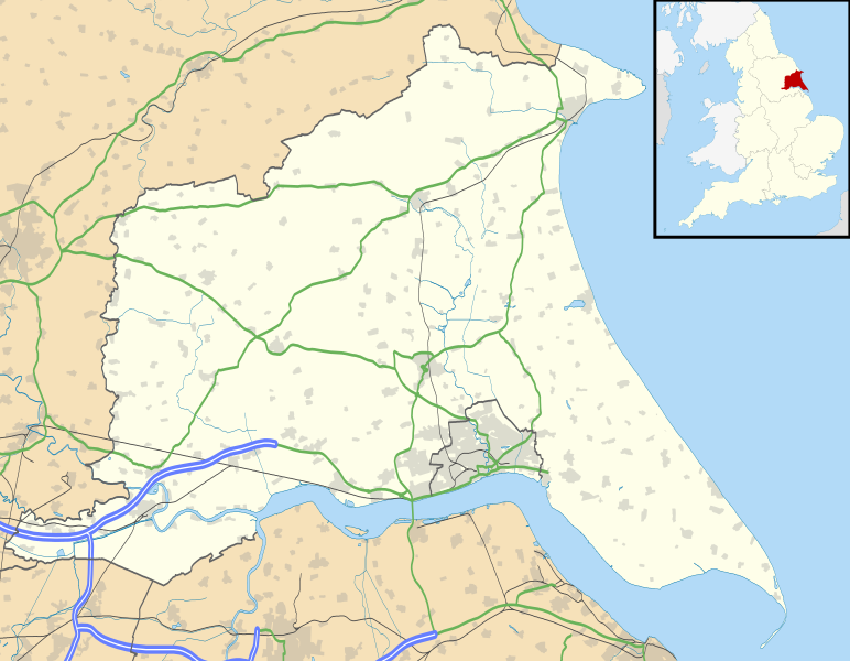
Map of the East Riding of Yorkshire, UK with the following information shown:
Equirectangular map projection on WGS 84 datum, with N/S stretched 165% Geographic limits:
|
| දිනය | |
| මූලාශ්රය |
|
| කර්තෘ | Nilfanion, created using Ordnance Survey data |
| අවසරය (මෙම ගොනුව නැවත භාවිතා කරමින්) |
මෙම ගොනුව ක්රියේටිව් කොමන්ස් Attribution-Share Alike 3.0 Unported වරපත යටතේ අවසර ලබා ඇත. Attribution: Contains Ordnance Survey data © Crown copyright and database right
|
| අනෙකුත් අනුවාදයන් | File:East Riding of Yorkshire UK district map (blank).svg - Blank map |
.svg)
ගොනු ඉතිහාසය
එම අවස්ථාවෙහිදී ගොනුව පැවැති ආකාරය නැරඹීමට දිනය/වේලාව මත ක්ලික් කරන්න.
| දිනය/වේලාව | කුඩා-රූපය | මාන | පරිශීලක | පරිකථනය | |
|---|---|---|---|---|---|
| වත්මන් | 18:48, 26 සැප්තැම්බර් 2010 | | 1,425 × 1,107 (1.33 මෙ.බ.) | Nilfanion | {{Information |Description=Map of the East Riding of Yorkshire, UK with the following information shown: *Administrative borders *Coastline, lakes and rivers *Roads and railways *Urban areas Equirectangular map projection o |
ගොනු භාවිතය
පහත දැක්වෙන පිටු 3 ක් විසින් මෙම ගොනුව භාවිතා කෙරෙයි:
ගෝලීය ගොනු භාවිතය
පහත දැක්වෙන අනෙකුත් විකියන් මගින් මෙම ගොනුව භාවිතා කරයි:
- ar.wikipedia.org හි භාවිතය
- bg.wikipedia.org හි භාවිතය
- ceb.wikipedia.org හි භාවිතය
- en.wikipedia.org හි භාවිතය
- Spurn
- Beverley
- East Riding of Yorkshire
- Everingham
- Goole
- Pocklington
- Bridlington
- Hornsea
- Haltemprice
- Goodmanham
- Driffield
- Wetwang
- Boothferry
- Stamford Bridge, East Riding of Yorkshire
- Bempton Cliffs
- Withernsea
- RAF Leconfield
- Fort Paull
- Market Weighton
- Hedon
- Hessle
- Millington, East Riding of Yorkshire
- Airmyn
- Flamborough
- List of civil parishes in the East Riding of Yorkshire
- Easington, East Riding of Yorkshire
- Wold Newton, East Riding of Yorkshire
- Burton Constable Hall
- Cottingham, East Riding of Yorkshire
- Arram
- Ferens Art Gallery
- Bridlington Priory
- Tibthorpe
- Wawne
- Langtoft, East Riding of Yorkshire
- Skelton, East Riding of Yorkshire
- Bilton, East Riding of Yorkshire
- Leven, East Riding of Yorkshire
- Burton Agnes
- Holme-on-Spalding-Moor
- Roos
- Middleton on the Wolds
- Howden
- Rudston
- Bishop Burton
- Sewerby
- Carnaby, East Riding of Yorkshire
මෙම ගොනුවේ තවත් ගෝලීය භාවිත බලන්න.