
ගොනුව:Chile location map (+claims, 1775).svg

මුල් ගොනුව (SVG ගොනුව, නාමමාත්රිකව 1,710 × 2,679 පික්සල්, ගොනු විශාලත්වය: 2.2 මෙ.බ.)
සාරාංශය
| විස්තරය |
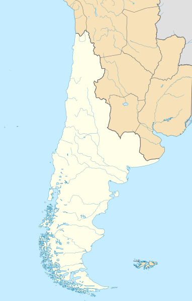
Español: Mapa de localización de la Capitanía General de Chile o Reino de Chile basado en los límites del mapa de la América Meridional hecho por Juan de la Cruz Cano y Olmedilla (1775) y el mapa general del Reyno de Chile de Andrés Baleato (1793) en el sector del desierto de Atacama.
Incluye todas las tierras del continente sudamericano que pobladas o no pertenecían al reino por derecho, entre estas la Patagonia, llamada como Tierras Magallánicas o Chile Moderno. Además incluye el territorio de Cuyo, segregado un año después con la creación del virreinato de la Plata.English: Location map of the Captaincy General of Chile or Kingdom of Chile based on the limits of the map of South America made by Juan de la Cruz Cano y Olmedilla (1775) and the general map of the Kingdom of Chile by Andrés Baleato (1793) in the sector of the Atacama Desert.
It includes all the lands of the South American continent that populated or not belonged to the kingdom by right, among these the Patagonia, called as Magellanic Lands or Modern Chile. It also includes the territory of Cuyo, segregated a year later with the creation of the viceroyalty of La Plata. |
||||||||||||||||||||
| දිනය | |||||||||||||||||||||
| මූලාශ්රය |
This file was derived from : Chile location map.svg by NordNordWest Reino de Chile según Juan de la Cruz Cano y Olmedilla, 1775.jpg Límite entre Chile y Perú en el río Loa, Plano General del Reyno de Chile en la América Meridional de Andrés Baleato (1793).jpg ස්වයං නිර්මාණයකි |
||||||||||||||||||||
| කර්තෘ |
Andrés Baleato
|
||||||||||||||||||||
| අනෙකුත් අනුවාදයන් |
    |
||||||||||||||||||||
.jpg)
.svg)
.jpg)
බලපත්රීකරණය
- ඔබ නිදහස්:
- බෙදාහදා ගැනීමට – කාර්යය පිටපත් කිරීමට,බෙදා හැරීමට සහ සම්ප්රේෂණය කිරීමට
- නැවත සංකලනය කිරීමට – කාර්යයට අනුවර්තනය වීමට
- පහත කොන්දේසිවලට යටත්ව:
- attribution – වරපත වෙත බැඳියක්ද සපයමින් ඔබ විසින් සුදුසු කර්තෘභාරය ප්රදානය කල යුතු අතර, කිසියම් වෙනස්වීම් සිදුකලේ නම් එයද සඳහන් කල යුතු වෙයි. ඕනෑම සුදුසු ආකාරයට මෙය ඔබ විසින් සිදුකල හැකි මුත්, වරපත්දායකයා විසින් ඔබ හෝ ඔබගේ භාවිතය හෝ පිටසන් කරන බවට ඇඟවෙන ලෙසින් එය සිදු නොකල යුතු වෙයි.
- share alike – මෙම විෂය කාරණා භාවිතා කොට නැවත සංකලනය, ප්රතියෝජනය හෝ වැඩිදියුණුව කලේ නම්, ඉන්පසු ඔබගේ දායකත්වය ඔබ විසින් බෙදාහැරිය යුත්තේ මුල් වරපත හා සමාන හෝ සංගතික හෝ වරපතක් භාවිතා කරමිනි.
ගොනු ඉතිහාසය
එම අවස්ථාවෙහිදී ගොනුව පැවැති ආකාරය නැරඹීමට දිනය/වේලාව මත ක්ලික් කරන්න.
| දිනය/වේලාව | කුඩා-රූපය | මාන | පරිශීලක | පරිකථනය | |
|---|---|---|---|---|---|
| වත්මන් | 20:38, 4 දෙසැම්බර් 2022 | | 1,710 × 2,679 (2.2 මෙ.බ.) | Janitoalevic | . |
| 20:37, 4 දෙසැම්බර් 2022 |  | 1,710 × 2,684 (2.2 මෙ.බ.) | Janitoalevic | . | |
| 15:39, 22 නොවැම්බර් 2022 |  | 1,710 × 2,679 (2.04 මෙ.බ.) | Janitoalevic | Mejoras | |
| 21:32, 12 නොවැම්බර් 2022 |  | 1,710 × 2,679 (1.92 මෙ.බ.) | Janitoalevic | . | |
| 21:22, 12 නොවැම්බර් 2022 |  | 1,710 × 2,679 (1.91 මෙ.බ.) | Janitoalevic | Fix | |
| 20:33, 11 නොවැම්බර් 2022 |  | 1,710 × 2,679 (1.76 මෙ.බ.) | Janitoalevic | Uploaded own work with UploadWizard |
ගොනු භාවිතය
පහත දැක්වෙන පිටු 2 ක් විසින් මෙම ගොනුව භාවිතා කෙරෙයි:
ගෝලීය ගොනු භාවිතය
පහත දැක්වෙන අනෙකුත් විකියන් මගින් මෙම ගොනුව භාවිතා කරයි:
- en.wikipedia.org හි භාවිතය
- uz.wikipedia.org හි භාවිතය
.svg)