
ගොනුව:Boundaries of the Okinawan Languages.svg

Size of this PNG preview of this SVG file: 736 × 600 පික්සල. අනෙකුත් විභේදනයන්: 295 × 240 පික්සල | 589 × 480 පික්සල | 942 × 768 පික්සල | 1,257 × 1,024 පික්සල | 2,513 × 2,048 පික්සල.
මුල් ගොනුව (SVG ගොනුව, නාමමාත්රිකව 800 × 652 පික්සල්, ගොනු විශාලත්වය: 21 කි.බ.)
සාරාංශය
| විස්තරය |
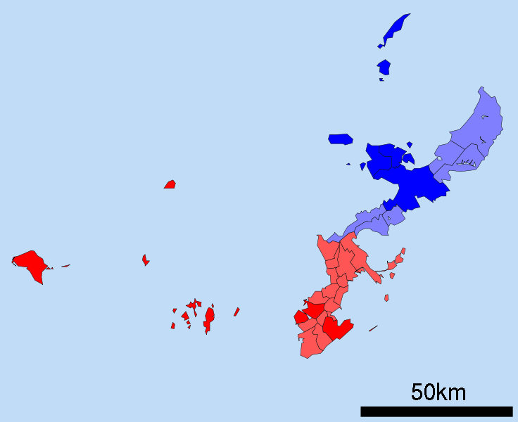
English: A map of the Okinawan Islands displaying the distribution of the Northern Okinawan Language (Kunigami) in blue, and the South-Central Okinawan Language (Shuri-Naha) in red. The darker areas represent regions that have been officially classified by the following sources:
|
| දිනය | (UTC) |
| මූලාශ්රය | Map_of_Okinawa_Prefecture_Ja.svg |
| කර්තෘ |
|
| This is a retouched picture, which means that it has been digitally altered from its original version. Modifications: Removed the Daito, Yaeyama, Miyako and Yonaguni islands. Changed all the links to point towards their English Wikipedia counterparts. Changed the colours on the map to demonstrate the Okinawan language boundaries.. The original can be viewed here: Map of Okinawa Prefecture Ja.svg:
|
බලපත්රීකරණය
I, මෙම කාර්යයේ ප්රකාශන අයිතිය දරන්නා,පහත බලපත්රය යටතේ එය ප්රකාශයට පත් කරනු ලබයි:
| මෙම ගොනුව ක්රියේටිව් කොමන්ස් Attribution-Share Alike 3.0 Unported වරපත යටතේ අවසර ලබා ඇත. | ||
| ||
| GFDL බලපත්ර යාවත්කාල කෙරුමහි කොටසක් ලෙස මෙම ගොනුවට බලපත්ර ටැගය එක් කෙරිනි. |

|
Free Software Foundation විසින් ප්රකාශිත GNU Free Documentation License බලපත්රයෙහි 1.2 හෝ ඊට අලුත් පිටපත්වල කොන්දේසිවලට යටත්ව මෙම ගොනුව පිටපත් කෙරුමට, නැවත බෙදාහාරුමට සහ/හෝ වෙනස් කෙරුමට අවසර දී ඇත; ඒ වෙනස් අංශ නොමැතිව, මුල් පිටු පෙළ නොමැතිව, පසු පිටු පෙළ නොමැතිවය. බලපත්රයේ පිටපතක් GNU Free Documentation License නම් අංශයේ දැක්වේ. |
ඔබට අභිමත වරපත තෝරාගත හැක.
ප්රකෘති පැටවුම් ලොගය
This image is a derivative work of the following images:
- File:Map_of_Okinawa_Prefecture_Ja.svg licensed with Cc-by-sa-3.0-migrated, GFDL
- 2008-04-30T00:12:31Z Krisgrotius 800x652 (14670 Bytes) {{Information| |Description= Map of Okinawa Prefecture, Japan. |Source= Japanese wiki [http://ja.wikipedia.org/wiki/%E7%94%BB%E5%83%8F:%E5%8C%85%E6%8B%AC%E8%87%AA%E6%B2%BB%E4%BD%93%E5%8C%BA%E7%94%BB%E5%9B%B3_47000.svg] |Da
Uploaded with derivativeFX
ගොනු ඉතිහාසය
එම අවස්ථාවෙහිදී ගොනුව පැවැති ආකාරය නැරඹීමට දිනය/වේලාව මත ක්ලික් කරන්න.
| දිනය/වේලාව | කුඩා-රූපය | මාන | පරිශීලක | පරිකථනය | |
|---|---|---|---|---|---|
| වත්මන් | 00:49, 25 දෙසැම්බර් 2010 | | 800 × 652 (21 කි.බ.) | Io Katai | fixed links |
| 00:47, 25 දෙසැම්බර් 2010 |  | 800 × 652 (21 කි.බ.) | Io Katai | Missed out on a few links | |
| 00:41, 25 දෙසැම්බර් 2010 |  | 800 × 652 (21 කි.බ.) | Io Katai | {{Information |Description=A map of the Okinawan Islands displaying the distribution of the Northern Okinawan Language (Kunigami) in blue, and the South-Central Okinawan Language (Shuri-Naha) in red. The darker areas represent regions that have been offic |
ගොනු භාවිතය
පහත දැක්වෙන පිටුව විසින් මෙම ගොනුව භාවිතා කෙරෙයි:
ගෝලීය ගොනු භාවිතය
පහත දැක්වෙන අනෙකුත් විකියන් මගින් මෙම ගොනුව භාවිතා කරයි:
- ast.wikipedia.org හි භාවිතය
- ca.wikipedia.org හි භාවිතය
- cdo.wikipedia.org හි භාවිතය
- cs.wikipedia.org හි භාවිතය
- en.wikipedia.org හි භාවිතය
- et.wikipedia.org හි භාවිතය
- fa.wikipedia.org හි භාවිතය
- fi.wikipedia.org හි භාවිතය
- gd.wikipedia.org හි භාවිතය
- gl.wikipedia.org හි භාවිතය
- gn.wikipedia.org හි භාවිතය
- haw.wikipedia.org හි භාවිතය
- hu.wikipedia.org හි භාවිතය
- iba.wikipedia.org හි භාවිතය
- id.wikipedia.org හි භාවිතය
- incubator.wikimedia.org හි භාවිතය
- it.wikipedia.org හි භාවිතය
- ja.wikipedia.org හි භාවිතය
- kge.wikipedia.org හි භාවිතය
- ko.wikipedia.org හි භාවිතය
- ms.wikipedia.org හි භාවිතය
- pt.wikipedia.org හි භාවිතය
- ru.wikipedia.org හි භාවිතය
- sc.wikipedia.org හි භාවිතය
- simple.wikipedia.org හි භාවිතය
- sr.wikipedia.org හි භාවිතය
- sv.wikipedia.org හි භාවිතය
- th.wikipedia.org හි භාවිතය
- tr.wikipedia.org හි භාවිතය
- uk.wikipedia.org හි භාවිතය
- vi.wikipedia.org හි භාවිතය
- zh-min-nan.wikipedia.org හි භාවිතය
- zh.wikipedia.org හි භාවිතය