
ගොනුව:Baltic states location map.svg

මුල් ගොනුව (SVG ගොනුව, නාමමාත්රිකව 660 × 992 පික්සල්, ගොනු විශාලත්වය: 358 කි.බ.)
සාරාංශය
| විස්තරය |
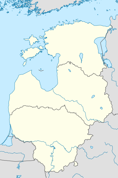
Deutsch: Positionskarte der baltischen Staaten
Quadratische Plattkarte, N-S-Streckung 184 %. Geographische Begrenzung der Karte:
English: Location map of the Baltic states
Equirectangular projection, N/S stretching 184 %. Geographic limits of the map:
|
|
| දිනය | ||
| මූලාශ්රය |
ස්වයං නිර්මාණයකි, using
|
|
| කර්තෘ | NordNordWest | |
| අවසරය (මෙම ගොනුව නැවත භාවිතා කරමින්) |
මෙම ගොනුව උත්පාදක සාර්වයන් Attribution-Share Alike 3.0 Germany වරපත යටතේ අවසර ලබා ඇත.
 මෙම ගොනුව ක්රියේටිව් කොමන්ස් Attribution-Share Alike 3.0 Unported වරපත යටතේ අවසර ලබා ඇත.
|


|
This map has been made or improved in the German Kartenwerkstatt (Map Lab). You can propose maps to improve as well.
|
ගොනු ඉතිහාසය
එම අවස්ථාවෙහිදී ගොනුව පැවැති ආකාරය නැරඹීමට දිනය/වේලාව මත ක්ලික් කරන්න.
| දිනය/වේලාව | කුඩා-රූපය | මාන | පරිශීලක | පරිකථනය | |
|---|---|---|---|---|---|
| වත්මන් | 21:01, 1 පෙබරවාරි 2011 | | 660 × 992 (358 කි.බ.) | NordNordWest | == {{int:filedesc}} == {{de|Positionskarte der baltischen Staaten}} Quadratische Plattkarte, N-S-Streckung 184 %. Geographische Begrenzung der Karte: * N: 60.4° N * S: 53.7° N * W: 20.4° O * O: 28.6° O {{en|Location map of th |
ගොනු භාවිතය
පහත දැක්වෙන පිටු 2 ක් විසින් මෙම ගොනුව භාවිතා කෙරෙයි:
ගෝලීය ගොනු භාවිතය
පහත දැක්වෙන අනෙකුත් විකියන් මගින් මෙම ගොනුව භාවිතා කරයි:
- ar.wikipedia.org හි භාවිතය
- ba.wikipedia.org හි භාවිතය
- bn.wikipedia.org හි භාවිතය
- ceb.wikipedia.org හි භාවිතය
- da.wikipedia.org හි භාවිතය
- de.wikipedia.org හි භාවිතය
- Benutzer:Spischot/Sketchpad 3
- Air Policing Baltikum
- BaltNet
- Wikipedia:Kartenwerkstatt/Positionskarten/Europa
- Vorlage:Positionskarte Baltische Staaten
- Benutzer:Gps-for-five/Spielwiese/Vorlage:Suche Poskarte
- Benutzer:Gps-for-five/Spielwiese/Vorlage:Suche Poskarte/Doku
- Vorlage:Suche Positionskarte
- Vorlage:Suche Positionskarte/Doku
- Livländisch-Estnischer Kriegsschauplatz
- en.wikipedia.org හි භාවිතය
- Riga
- Vilnius
- Klaipėda
- Kaunas
- Kuressaare
- Nida, Lithuania
- Telšiai
- Battle of Saule
- Mažeikiai
- Panevėžys
- Jonava
- Utena
- Baltic Air Surveillance Network
- Lyduvėnai
- Module:Location map/data/Baltic states/doc
- 2012–13 Baltic Basketball League
- 2015–16 Baltic Basketball League
- 2015–16 Baltic Men Volleyball League
- 2016–17 Baltic Men Volleyball League
- 2016–17 Baltic Basketball League
- 2017–18 Baltic Men Volleyball League
- Module:Location map/data/Baltic states
- 2020–21 Baltic Men Volleyball League
- Baltic Hockey League
- 2021–22 Baltic Men Volleyball League
- es.wikipedia.org හි භාවිතය
- et.wikipedia.org හි භාවිතය
මෙම ගොනුවේ තවත් ගෝලීය භාවිත බලන්න.