
ගොනුව:Austria relief location map.jpg

මෙම පෙරදසුනෙහි විශාලත්වය: 800 × 446 පික්සල. අනෙකුත් විභේදනයන්: 320 × 178 පික්සල | 640 × 357 පික්සල | 1,256 × 700 පික්සල.
මුල් ගොනුව (1,256 × 700 පික්සල, ගොනු විශාලත්වය: 677 කි.බ., MIME ශෛලිය: image/jpeg)
සාරාංශය
| විස්තරය |
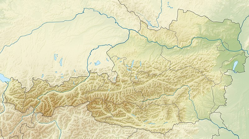
English: Location map of Austria
Equirectangular projection, N/S stretching 150 %. Geographic limits of the map:
|
| දිනය | |
| මූලාශ්රය | ස්වයං නිර්මාණයකි |
| කර්තෘ | Uwe Dedering |
| අනෙකුත් අනුවාදයන් |
Derivative works of this file: ÖRF 2011.png
|

බලපත්රීකරණය
I, මෙම කාර්යයේ ප්රකාශන අයිතිය දරන්නා,පහත බලපත්රය යටතේ එය ප්රකාශයට පත් කරනු ලබයි:
මෙම ගොනුව ක්රියේටිව් කොමන්ස් Attribution-Share Alike 3.0 Unported වරපත යටතේ අවසර ලබා ඇත.
- ඔබ නිදහස්:
- බෙදාහදා ගැනීමට – කාර්යය පිටපත් කිරීමට,බෙදා හැරීමට සහ සම්ප්රේෂණය කිරීමට
- නැවත සංකලනය කිරීමට – කාර්යයට අනුවර්තනය වීමට
- පහත කොන්දේසිවලට යටත්ව:
- attribution – වරපත වෙත බැඳියක්ද සපයමින් ඔබ විසින් සුදුසු කර්තෘභාරය ප්රදානය කල යුතු අතර, කිසියම් වෙනස්වීම් සිදුකලේ නම් එයද සඳහන් කල යුතු වෙයි. ඕනෑම සුදුසු ආකාරයට මෙය ඔබ විසින් සිදුකල හැකි මුත්, වරපත්දායකයා විසින් ඔබ හෝ ඔබගේ භාවිතය හෝ පිටසන් කරන බවට ඇඟවෙන ලෙසින් එය සිදු නොකල යුතු වෙයි.
- share alike – මෙම විෂය කාරණා භාවිතා කොට නැවත සංකලනය, ප්රතියෝජනය හෝ වැඩිදියුණුව කලේ නම්, ඉන්පසු ඔබගේ දායකත්වය ඔබ විසින් බෙදාහැරිය යුත්තේ මුල් වරපත හා සමාන හෝ සංගතික හෝ වරපතක් භාවිතා කරමිනි.

|
Free Software Foundation විසින් ප්රකාශිත GNU Free Documentation License බලපත්රයෙහි 1.2 හෝ ඊට අලුත් පිටපත්වල කොන්දේසිවලට යටත්ව මෙම ගොනුව පිටපත් කෙරුමට, නැවත බෙදාහාරුමට සහ/හෝ වෙනස් කෙරුමට අවසර දී ඇත; ඒ වෙනස් අංශ නොමැතිව, මුල් පිටු පෙළ නොමැතිව, පසු පිටු පෙළ නොමැතිවය. බලපත්රයේ පිටපතක් GNU Free Documentation License නම් අංශයේ දැක්වේ. |
ඔබට අභිමත වරපත තෝරාගත හැක.

|
This map image could be re-created using vector graphics as an SVG file. This has several advantages; see Commons:Media for cleanup for more information. If an SVG form of this image is available, please upload it and afterwards replace this template with
{{vector version available|new image name}}.
It is recommended to name the SVG file “Austria relief location map.svg”—then the template Vector version available (or Vva) does not need the new image name parameter. |


ගොනු ඉතිහාසය
එම අවස්ථාවෙහිදී ගොනුව පැවැති ආකාරය නැරඹීමට දිනය/වේලාව මත ක්ලික් කරන්න.
| දිනය/වේලාව | කුඩා-රූපය | මාන | පරිශීලක | පරිකථනය | |
|---|---|---|---|---|---|
| වත්මන් | 09:14, 28 ජූනි 2010 | | 1,256 × 700 (677 කි.බ.) | Uwe Dedering | very little border change |
| 12:24, 26 අප්රේල් 2010 |  | 1,256 × 700 (677 කි.බ.) | Uwe Dedering | rhine | |
| 12:54, 24 අප්රේල් 2010 |  | 1,256 × 700 (676 කි.බ.) | Uwe Dedering | {{Information |Description={{en|1=Location map of Austria}} Equirectangular projection, N/S stretching 150 %. Geographic limits of the map: * N: 49.2° N * S: 46.3° N * W: 9.4° E * E: 17.2° E Made with Natural Earth. Free |
ගොනු භාවිතය
පහත දැක්වෙන පිටු 5 ක් විසින් මෙම ගොනුව භාවිතා කෙරෙයි:
ගෝලීය ගොනු භාවිතය
පහත දැක්වෙන අනෙකුත් විකියන් මගින් මෙම ගොනුව භාවිතා කරයි:
- ab.wikipedia.org හි භාවිතය
- als.wikipedia.org හි භාවිතය
- am.wikipedia.org හි භාවිතය
- an.wikipedia.org හි භාවිතය
- ar.wikipedia.org හි භාවිතය
- arz.wikipedia.org හි භාවිතය
- ast.wikipedia.org හි භාවිතය
- as.wikipedia.org හි භාවිතය
- azb.wikipedia.org හි භාවිතය
- az.wikipedia.org හි භාවිතය
- ban.wikipedia.org හි භාවිතය
- ba.wikipedia.org හි භාවිතය
- be-tarask.wikipedia.org හි භාවිතය
- be.wikipedia.org හි භාවිතය
- bh.wikipedia.org හි භාවිතය
- bn.wikipedia.org හි භාවිතය
මෙම ගොනුවේ තවත් ගෝලීය භාවිත බලන්න.