
ගොනුව:Australia Victoria Warrnambool City location map.svg

Size of this PNG preview of this SVG file: 534 × 346 පික්සල. අනෙකුත් විභේදනයන්: 320 × 207 පික්සල | 640 × 415 පික්සල | 1,024 × 663 පික්සල | 1,280 × 829 පික්සල | 2,560 × 1,659 පික්සල.
මුල් ගොනුව (SVG ගොනුව, නාමමාත්රිකව 534 × 346 පික්සල්, ගොනු විශාලත්වය: 396 කි.බ.)
| විස්තරය |
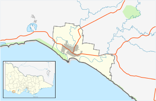
English: Blank map of w:Warrnambool City, Victoria, Australia, with the following information shown:
Geographic limits:
|
||
| මූලාශ්රය | ස්වයං නිර්මාණයකි + VicMap Lite | ||
| කර්තෘ | Cassowary |

ගොනු ඉතිහාසය
එම අවස්ථාවෙහිදී ගොනුව පැවැති ආකාරය නැරඹීමට දිනය/වේලාව මත ක්ලික් කරන්න.
| දිනය/වේලාව | කුඩා-රූපය | මාන | පරිශීලක | පරිකථනය | |
|---|---|---|---|---|---|
| වත්මන් | 14:04, 18 පෙබරවාරි 2011 | | 534 × 346 (396 කි.බ.) | Cassowary | {{Information |Description ={{en|1=Blank map of w:Warrnambool City, Victoria, Australia, with the following information shown: * LGA boundaries * Coastline, lakes and rivers * Roads and railways * Urban areas * Parks Geographic limits: * North: 38 |
ගොනු භාවිතය
පහත දැක්වෙන පිටු 2 ක් විසින් මෙම ගොනුව භාවිතා කෙරෙයි:
ගෝලීය ගොනු භාවිතය
පහත දැක්වෙන අනෙකුත් විකියන් මගින් මෙම ගොනුව භාවිතා කරයි:
- ar.wikipedia.org හි භාවිතය
- ceb.wikipedia.org හි භාවිතය
- en.wikipedia.org හි භාවිතය
- City of Warrnambool
- Warrnambool
- Allansford, Victoria
- Woodford, Victoria
- Bushfield, Victoria
- Template:Towns in the City of Warrnambool
- Dennington, Victoria
- Module:Location map/data/Australia Victoria City of Warrnambool/doc
- Module:Location map/data/Australia Victoria City of Warrnambool
- User:Viatori/sandbox
- Yangery
- Illowa
- User:ThylacineHunter/LGA
- fa.wikipedia.org හි භාවිතය
- kn.wikipedia.org හි භාවිතය
- tr.wikipedia.org හි භාවිතය
- uz.wikipedia.org හි භාවිතය
- war.wikipedia.org හි භාවිතය