
ගොනුව:Australia Victoria Southern Grampians Shire location map.svg

Size of this PNG preview of this SVG file: 533 × 491 පික්සල. අනෙකුත් විභේදනයන්: 261 × 240 පික්සල | 521 × 480 පික්සල | 834 × 768 පික්සල | 1,112 × 1,024 පික්සල | 2,223 × 2,048 පික්සල.
මුල් ගොනුව (SVG ගොනුව, නාමමාත්රිකව 533 × 491 පික්සල්, ගොනු විශාලත්වය: 640 කි.බ.)
| විස්තරය |
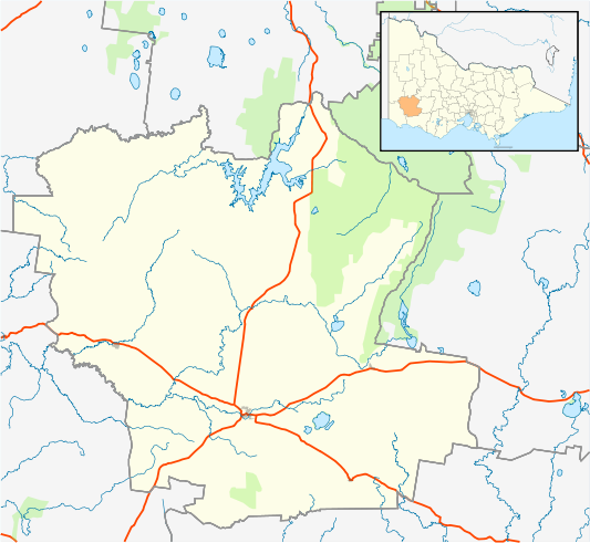
English: Blank map of w:Southern Grampians Shire, Victoria, Australia, with the following information shown:
Geographic limits:
|
||
| මූලාශ්රය | ස්වයං නිර්මාණයකි + VicMap Lite | ||
| කර්තෘ | Cassowary |

ගොනු ඉතිහාසය
එම අවස්ථාවෙහිදී ගොනුව පැවැති ආකාරය නැරඹීමට දිනය/වේලාව මත ක්ලික් කරන්න.
| දිනය/වේලාව | කුඩා-රූපය | මාන | පරිශීලක | පරිකථනය | |
|---|---|---|---|---|---|
| වත්මන් | 16:00, 18 පෙබරවාරි 2011 | | 533 × 491 (640 කි.බ.) | Cassowary | {{Information |Description ={{en|1=Blank map of w:Southern Grampians Shire, Victoria, Australia, with the following information shown: * LGA boundaries * Coastline, lakes and rivers * Highways and freeways * Urban areas * Parks Geographic limits: |
ගොනු භාවිතය
පහත දැක්වෙන පිටු 2 ක් විසින් මෙම ගොනුව භාවිතා කෙරෙයි:
ගෝලීය ගොනු භාවිතය
පහත දැක්වෙන අනෙකුත් විකියන් මගින් මෙම ගොනුව භාවිතා කරයි:
- ar.wikipedia.org හි භාවිතය
- ceb.wikipedia.org හි භාවිතය
- en.wikipedia.org හි භාවිතය
- Shire of Southern Grampians
- Hamilton, Victoria
- Coleraine, Victoria
- Penshurst, Victoria
- Dunkeld, Victoria
- Glenthompson, Victoria
- Template:Towns in Southern Grampians Shire
- Tabor, Victoria
- Tarrington, Victoria
- Balmoral, Victoria
- Branxholme, Victoria
- Byaduk
- Cavendish, Victoria
- Module:Location map/data/Australia Victoria Shire of Southern Grampians/doc
- Pigeon Ponds
- Konongwootong
- Tahara, Victoria
- Module:Location map/data/Australia Victoria Shire of Southern Grampians
- User:Viatori/sandbox
- User:ThylacineHunter/LGA
- Brit Brit, Victoria
- Bochara, Victoria
- Gringegalgona, Victoria
- fa.wikipedia.org හි භාවිතය
- kn.wikipedia.org හි භාවිතය
- tr.wikipedia.org හි භාවිතය
- uz.wikipedia.org හි භාවිතය
- war.wikipedia.org හි භාවිතය