
ගොනුව:Australia Victoria Moira Shire location map.svg

Size of this PNG preview of this SVG file: 535 × 321 පික්සල. අනෙකුත් විභේදනයන්: 320 × 192 පික්සල | 640 × 384 පික්සල | 1,024 × 614 පික්සල | 1,280 × 768 පික්සල | 2,560 × 1,536 පික්සල.
මුල් ගොනුව (SVG ගොනුව, නාමමාත්රිකව 535 × 321 පික්සල්, ගොනු විශාලත්වය: 540 කි.බ.)
| විස්තරය |
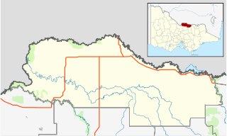
English: Blank map of w:Moira Shire, Victoria, Australia, with the following information shown:
Geographic limits:
|
||
| මූලාශ්රය | ස්වයං නිර්මාණයකි + VicMap Lite | ||
| කර්තෘ | Cassowary |

ගොනු ඉතිහාසය
එම අවස්ථාවෙහිදී ගොනුව පැවැති ආකාරය නැරඹීමට දිනය/වේලාව මත ක්ලික් කරන්න.
| දිනය/වේලාව | කුඩා-රූපය | මාන | පරිශීලක | පරිකථනය | |
|---|---|---|---|---|---|
| වත්මන් | 17:56, 18 පෙබරවාරි 2011 | | 535 × 321 (540 කි.බ.) | Cassowary | {{Information |Description ={{en|1=Blank map of w:Moria Shire, Victoria, Australia, with the following information shown: * LGA boundaries * Coastline, lakes and rivers * Highways and freeways * Urban areas * Parks Geographic limits: * North: 35.6 |
ගොනු භාවිතය
පහත දැක්වෙන පිටු 2 ක් විසින් මෙම ගොනුව භාවිතා කෙරෙයි:
ගෝලීය ගොනු භාවිතය
පහත දැක්වෙන අනෙකුත් විකියන් මගින් මෙම ගොනුව භාවිතා කරයි:
- ar.wikipedia.org හි භාවිතය
- ceb.wikipedia.org හි භාවිතය
- en.wikipedia.org හි භාවිතය
- Shire of Moira
- Barmah
- Strathmerton
- Cobram
- Yarrawonga
- Numurkah
- Nathalia, Victoria
- Katamatite
- Katunga
- Tungamah
- Wunghnu
- Template:Towns in Moira Shire
- Bundalong, Victoria
- Cobram East
- Yarroweyah
- Picola
- Waaia
- St James, Victoria
- Bearii
- Koonoomoo
- Peechelba
- Invergordon, Victoria
- Telford, Victoria
- Module:Location map/data/Australia Victoria Shire of Moira/doc
- Youanmite
- Almonds, Victoria
- Wilby, Victoria
- Lower Moira
- Yalca
- Picola West
- Kotupna
- Yielima
- Kaarimba
- Mundoona
- Ulupna
- Mywee
- Drumanure
- Marungi
- Naring
- Muckatah
- Yabba North
- Yabba South
- Katamatite East
- Waggarandall
- Boosey, Victoria
- Youarang
- Yundool
- Burramine
මෙම ගොනුවේ තවත් ගෝලීය භාවිත බලන්න.