
ගොනුව:Australia Victoria Colac Otway Shire location map.svg

Size of this PNG preview of this SVG file: 419 × 599 පික්සල. අනෙකුත් විභේදනයන්: 168 × 240 පික්සල | 336 × 480 පික්සල | 537 × 768 පික්සල | 717 × 1,024 පික්සල | 1,433 × 2,048 පික්සල | 534 × 763 පික්සල.
මුල් ගොනුව (SVG ගොනුව, නාමමාත්රිකව 534 × 763 පික්සල්, ගොනු විශාලත්වය: 655 කි.බ.)
| විස්තරය |
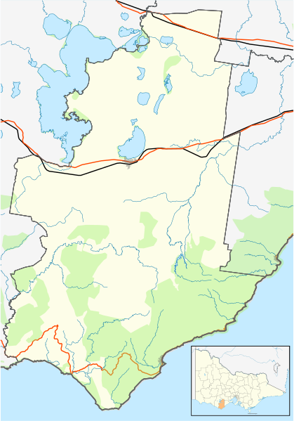
English: Blank map of w:Colac Otway Shire, Victoria, Australia, with the following information shown:
Geographic limits:
|
||
| මූලාශ්රය | ස්වයං නිර්මාණයකි | ||
| කර්තෘ | Cassowary |

ගොනු ඉතිහාසය
එම අවස්ථාවෙහිදී ගොනුව පැවැති ආකාරය නැරඹීමට දිනය/වේලාව මත ක්ලික් කරන්න.
| දිනය/වේලාව | කුඩා-රූපය | මාන | පරිශීලක | පරිකථනය | |
|---|---|---|---|---|---|
| වත්මන් | 12:29, 17 පෙබරවාරි 2011 | | 534 × 763 (655 කි.බ.) | Cassowary | {{Information |Description ={{en|1=Blank map of w:Colac Otway Shire, Victoria, Australia, with the following information shown: * LGA boundaries * Coastline, lakes and rivers * Roads and railways * Urban areas * Parks Geographic limits: * North: |
ගොනු භාවිතය
පහත දැක්වෙන පිටු 2 ක් විසින් මෙම ගොනුව භාවිතා කෙරෙයි:
ගෝලීය ගොනු භාවිතය
පහත දැක්වෙන අනෙකුත් විකියන් මගින් මෙම ගොනුව භාවිතා කරයි:
- ar.wikipedia.org හි භාවිතය
- ceb.wikipedia.org හි භාවිතය
- en.wikipedia.org හි භාවිතය
- Colac, Victoria
- Shire of Colac Otway
- Apollo Bay
- Winchelsea, Victoria
- Kennett River, Victoria
- Wye River, Victoria
- Alvie, Victoria
- Forrest, Victoria
- Johanna, Victoria
- Warrion, Victoria
- Cressy, Victoria
- Birregurra
- Cape Otway
- Lavers Hill
- Beeac
- Beech Forest, Victoria
- Template:Towns in Colac Otway Shire
- Simpson, Victoria
- User:Gerixau/temp2
- Swan Marsh
- Module:Location map/data/Australia Victoria Colac Otway Shire/doc
- Barwon Downs
- Gellibrand, Victoria
- Ombersley, Victoria
- Pennyroyal, Victoria
- Separation Creek, Victoria
- Mount Sabine, Victoria
- Grey River, Victoria
- Wongarra, Victoria
- Sugarloaf, Victoria
- Petticoat Creek, Victoria
- Balintore, Victoria
- Pirron Yallock, Victoria
- Ferguson, Victoria
- Irrewillipe
- Larpent, Victoria
- Skenes Creek North, Victoria
- Module:Location map/data/Australia Victoria Colac Otway Shire
- Skenes Creek, Victoria
- Aire Valley, Victoria
- Tanybryn, Victoria
- Marengo, Victoria
- User:Viatori/sandbox
- Barongarook, Victoria
- User:ThylacineHunter/LGA
- Cororooke, Victoria
- Irrewarra, Victoria
- Barongarook West, Victoria
මෙම ගොනුවේ තවත් ගෝලීය භාවිත බලන්න.