
ගොනුව:Asturias location map.svg

Size of this PNG preview of this SVG file: 512 × 378 පික්සල. අනෙකුත් විභේදනයන්: 320 × 236 පික්සල | 640 × 473 පික්සල | 1,024 × 756 පික්සල | 1,280 × 945 පික්සල | 2,560 × 1,890 පික්සල.
මුල් ගොනුව (SVG ගොනුව, නාමමාත්රිකව 512 × 378 පික්සල්, ගොනු විශාලත්වය: 158 කි.බ.)
| විස්තරය |
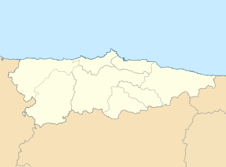
English: Location map of Asturias Equirectangular projection, N/S stretching 130 %. Geographic limits of the map: * N: 44.141° N * S: 42.498° N * W: 7.286° O * E: 4.375° O Español: Mapa de localización de Asturias Proyección equirrectangular, N/S estirada 130 %. Límites geográficos del mapa: * N: 44.141° N * S: 42.498° N * W: 7.286° O * E: 4.375° O |
| දිනය | (UTC) |
| මූලාශ්රය | |
| කර්තෘ |
|
| අනෙකුත් අනුවාදයන් | Derivative works of this file: Circunscripciones electorales Asturias.svg |
| This is a retouched picture, which means that it has been digitally altered from its original version. Modifications: harmonisation des couleurs. The original can be viewed here: Asturias-loc.svg:
|
මෙම කෘතියෙහි හිමිකම් අයිතීන් දරන්නා වන මම,පහත වරපත යටතේ එය ප්රකාශයට පත් කරමි:
මෙම ගොනුව ක්රියේටිව් කොමන්ස් Attribution-Share Alike 3.0 Unported වරපත යටතේ අවසර ලබා ඇත.
- ඔබ නිදහස්:
- බෙදාහදා ගැනීමට – කාර්යය පිටපත් කිරීමට,බෙදා හැරීමට සහ සම්ප්රේෂණය කිරීමට
- නැවත සංකලනය කිරීමට – කාර්යයට අනුවර්තනය වීමට
- පහත කොන්දේසිවලට යටත්ව:
- attribution – වරපත වෙත බැඳියක්ද සපයමින් ඔබ විසින් සුදුසු කර්තෘභාරය ප්රදානය කල යුතු අතර, කිසියම් වෙනස්වීම් සිදුකලේ නම් එයද සඳහන් කල යුතු වෙයි. ඕනෑම සුදුසු ආකාරයට මෙය ඔබ විසින් සිදුකල හැකි මුත්, වරපත්දායකයා විසින් ඔබ හෝ ඔබගේ භාවිතය හෝ පිටසන් කරන බවට ඇඟවෙන ලෙසින් එය සිදු නොකල යුතු වෙයි.
- share alike – මෙම විෂය කාරණා භාවිතා කොට නැවත සංකලනය, ප්රතියෝජනය හෝ වැඩිදියුණුව කලේ නම්, ඉන්පසු ඔබගේ දායකත්වය ඔබ විසින් බෙදාහැරිය යුත්තේ මුල් වරපත හා සමාන හෝ සංගතික හෝ වරපතක් භාවිතා කරමිනි.
ප්රකෘති පැටවුම් ලොගය
This image is a derivative work of the following images:
- File:Asturias-loc.svg licensed with Cc-by-sa-3.0
- 2010-05-07T11:44:07Z Miguillen 512x378 (272467 Bytes) {{Information |Description=Mapa delocalización del Principado de Asturias |Source={{own}} |Date=2009-05-07 |Author=[[User:Miguillen|Miguillen]] |Permission= |other_versions= }} [[Category:Maps of Asturias]]
Uploaded with derivativeFX
ගොනු ඉතිහාසය
එම අවස්ථාවෙහිදී ගොනුව පැවැති ආකාරය නැරඹීමට දිනය/වේලාව මත ක්ලික් කරන්න.
| දිනය/වේලාව | කුඩා-රූපය | මාන | පරිශීලක | පරිකථනය | |
|---|---|---|---|---|---|
| වත්මන් | 11:07, 19 මැයි 2010 | | 512 × 378 (158 කි.බ.) | Miguillen | borde de costa |
| 09:49, 18 මැයි 2010 |  | 512 × 378 (144 කි.බ.) | Xfigpower | {{Information |Description={{en|Location map of Asturias}} Equirectangular projection, N/S stretching 130 %. Geographic limits of the map: * N: 44.141° N * S: 42.498° N * W: 7.286° O * E: 4.375° O {{es|Mapa de localización de [ |
ගොනු භාවිතය
පහත දැක්වෙන පිටු 2 ක් විසින් මෙම ගොනුව භාවිතා කෙරෙයි:
ගෝලීය ගොනු භාවිතය
පහත දැක්වෙන අනෙකුත් විකියන් මගින් මෙම ගොනුව භාවිතා කරයි:
- ast.wikipedia.org හි භාවිතය
- Villaviciosa
- Xixón
- Castiello Bernueces (parroquia)
- Valdornón
- Cabueñes
- Caldones (parroquia)
- L'Abadía Cenero
- Deva (parroquia)
- Fano (parroquia)
- Fresno (parroquia)
- Granda (Xixón)
- Samartín de Güerces
- Llavandera (parroquia)
- Llorio
- La Pedrera (parroquia)
- Porceyo
- Puao
- Roces (Xixón)
- Ruedes (parroquia)
- Santurio
- Serín
- Somió
- San Andrés de los Tacones
- Vega (Xixón)
- Veriña
- Xove
- Naves (parroquia de Llanes)
- Cecos (parroquia)
- Santolaya de Vixil
- Zardaín (parroquia)
- Navelgas (parroquia)
- Santolaya de Miñu
- La Puela (parroquia)
- Caborana (parroquia)
- Uxo (parroquia)
- Celoriu (Llanes)
- Universidá d'Uviéu
- Ríu Nalón
- Blimea (parroquia)
- Santa Bárbola
- Bisuyu (Allande)
- Bustantigo (parroquia)
- San Andrés (Trubia)
- Lliberdón (parroquia)
- Cuadonga
- Llastres (parroquia)
- Berducedo (parroquia)
- Llago (parroquia)
- Ḷḷinares (parroquia d'Allande)
- Ḷḷomes (parroquia)
මෙම ගොනුවේ තවත් ගෝලීය භාවිත බලන්න.