
ගොනුව:Ancient Regions Central Greece.png

මෙම පෙරදසුනෙහි විශාලත්වය: 600 × 600 පික්සල. අනෙකුත් විභේදනයන්: 240 × 240 පික්සල | 480 × 480 පික්සල.
මුල් ගොනුව (800 × 800 පික්සල, ගොනු විශාලත්වය: 393 කි.බ., MIME ශෛලිය: image/png)
| විස්තරය |
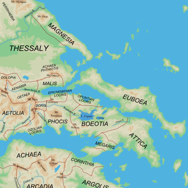
English: Map of the central regions of Ancient Greece |
| දිනය | (UTC) |
| මූලාශ්රය |
|
| කර්තෘ | User:MinisterForBadTimes |
| අනෙකුත් අනුවාදයන් |
Derivative works of this file: |
| This is a retouched picture, which means that it has been digitally altered from its original version. The original can be viewed here: Ancient Greek southern regions.png:
|
I, මෙම කාර්යයේ ප්රකාශන අයිතිය දරන්නා,පහත බලපත්රය යටතේ එය ප්රකාශයට පත් කරනු ලබයි:
මෙම ගොනුව නිර්මාණශීලී පොදුවූවන් Attribution-Share Alike 2.5 Generic බලපත්රය යටතේ අවසර ලබා ඇත.
- ඔබ නිදහස්:
- බෙදාහදා ගැනීමට – කාර්යය පිටපත් කිරීමට,බෙදා හැරීමට සහ සම්ප්රේෂණය කිරීමට
- නැවත සංකලනය කිරීමට – කාර්යයට අනුවර්තනය වීමට
- පහත කොන්දේසිවලට යටත්ව:
- attribution – වරපත වෙත බැඳියක්ද සපයමින් ඔබ විසින් සුදුසු කර්තෘභාරය ප්රදානය කල යුතු අතර, කිසියම් වෙනස්වීම් සිදුකලේ නම් එයද සඳහන් කල යුතු වෙයි. ඕනෑම සුදුසු ආකාරයට මෙය ඔබ විසින් සිදුකල හැකි මුත්, වරපත්දායකයා විසින් ඔබ හෝ ඔබගේ භාවිතය හෝ පිටසන් කරන බවට ඇඟවෙන ලෙසින් එය සිදු නොකල යුතු වෙයි.
- share alike – මෙම විෂය කාරණා භාවිතා කොට නැවත සංකලනය, ප්රතියෝජනය හෝ වැඩිදියුණුව කලේ නම්, ඉන්පසු ඔබගේ දායකත්වය ඔබ විසින් බෙදාහැරිය යුත්තේ මුල් වරපත හා සමාන හෝ සංගතික හෝ වරපතක් භාවිතා කරමිනි.
| මෙම ගොනුව ක්රියේටිව් කොමන්ස් Attribution-Share Alike 3.0 Unported වරපත යටතේ අවසර ලබා ඇත. | ||
| ||
| GFDL බලපත්ර යාවත්කාල කෙරුමහි කොටසක් ලෙස මෙම ගොනුවට බලපත්ර ටැගය එක් කෙරිනි. |

|
Free Software Foundation විසින් ප්රකාශිත GNU Free Documentation License බලපත්රයෙහි 1.2 හෝ ඊට අලුත් පිටපත්වල කොන්දේසිවලට යටත්ව මෙම ගොනුව පිටපත් කෙරුමට, නැවත බෙදාහාරුමට සහ/හෝ වෙනස් කෙරුමට අවසර දී ඇත; ඒ වෙනස් අංශ නොමැතිව, මුල් පිටු පෙළ නොමැතිව, පසු පිටු පෙළ නොමැතිවය. බලපත්රයේ පිටපතක් GNU Free Documentation License නම් අංශයේ දැක්වේ. |
ඔබට අභිමත වරපත තෝරාගත හැක.
ප්රකෘති පැටවුම් ලොගය
This image is a derivative work of the following images:
- File:Ancient_Greek_southern_regions.png licensed with Cc-by-sa-2.5, Cc-by-sa-3.0-migrated, GFDL
- 2010-01-12T08:44:56Z MinisterForBadTimes 800x800 (385822 Bytes) {{Information |Description={{en|Map of the regions of Ancient Greece}} |Source=*[[:File:Map_greek_sanctuaries-en.svg|]]. Geographical information based on public domain map of Greece, from the Perry-Castañeda Library Map Col
Uploaded with derivativeFX
ගොනු ඉතිහාසය
එම අවස්ථාවෙහිදී ගොනුව පැවැති ආකාරය නැරඹීමට දිනය/වේලාව මත ක්ලික් කරන්න.
| දිනය/වේලාව | කුඩා-රූපය | මාන | පරිශීලක | පරිකථනය | |
|---|---|---|---|---|---|
| වත්මන් | 20:41, 3 මාර්තු 2010 | | 800 × 800 (393 කි.බ.) | MinisterForBadTimes | Two spellings corrected |
| 21:44, 1 මාර්තු 2010 |  | 800 × 800 (393 කි.බ.) | MinisterForBadTimes | {{Information |Description={{en|Map of the central regions of Ancient Greece}} |Source=*blank(ish) map from Ancient_Greek_southern_regions.png, ultimately derived from [[:File:Map_greek_sanctuaries-en.svg|Map_g |
ගොනු භාවිතය
මෙම ගොනුව භාවිතා කරන නිසිදු පිටුවක් නොමැත.
ගෝලීය ගොනු භාවිතය
පහත දැක්වෙන අනෙකුත් විකියන් මගින් මෙම ගොනුව භාවිතා කරයි:
- azb.wikipedia.org හි භාවිතය
- bg.wikipedia.org හි භාවිතය
- cs.wikipedia.org හි භාවිතය
- de.wikipedia.org හි භාවිතය
- el.wikipedia.org හි භාවිතය
- en.wikipedia.org හි භාවිතය
- et.wikipedia.org හි භාවිතය
- fi.wikipedia.org හි භාවිතය
- fr.wikipedia.org හි භාවිතය
- hu.wikipedia.org හි භාවිතය
- id.wikipedia.org හි භාවිතය
- it.wikipedia.org හි භාවිතය
- ja.wikipedia.org හි භාවිතය
- ja.wikibooks.org හි භාවිතය
- la.wikipedia.org හි භාවිතය
- nn.wikipedia.org හි භාවිතය
- pl.wiktionary.org හි භාවිතය
- pnb.wikipedia.org හි භාවිතය
- ru.wikipedia.org හි භාවිතය
- sl.wikipedia.org හි භාවිතය
- sq.wikipedia.org හි භාවිතය
- tr.wikipedia.org හි භාවිතය
මෙම ගොනුවේ තවත් ගෝලීය භාවිත බලන්න.