
ගොනුව:African continent-en.svg

Size of this PNG preview of this SVG file: 635 × 600 පික්සල. අනෙකුත් විභේදනයන්: 254 × 240 පික්සල | 508 × 480 පික්සල | 813 × 768 පික්සල | 1,084 × 1,024 පික්සල | 2,169 × 2,048 පික්සල | 1,525 × 1,440 පික්සල.
මුල් ගොනුව (SVG ගොනුව, නාමමාත්රිකව 1,525 × 1,440 පික්සල්, ගොනු විශාලත්වය: 752 කි.බ.)
| විස්තරය |
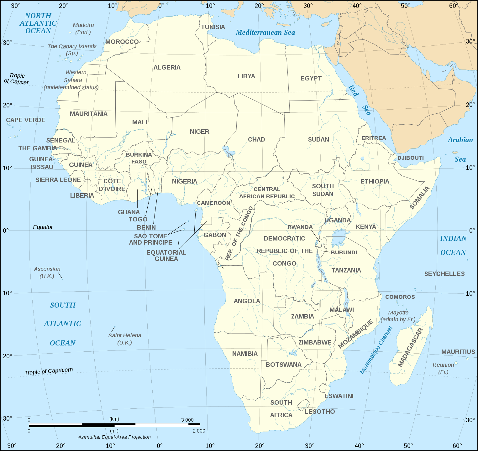
English: Map of the African continent as in 2011-07.
Français : Carte en anglais du continent africain tel qu'en 07/2011.
Lambert azimutal equal-area projection, WGS84 datum, standard meridian: 15°E, standard parallel: 0°Scale: 1:15,000,000 (accuracy: 3,75 km) |
||
| දිනය | (UTC), updated 2011-07 | ||
| මූලාශ්රය | |||
| කර්තෘ |
|
||
| අනෙකුත් අනුවාදයන් |
Derivative works of this file:
[]
Map close to Africa map political-fr.svg, but with some changes on the islands administrated by European countries and the Sinai peninsula |
||
| SVG genesis |
|


මෙම කෘතියෙහි හිමිකම් අයිතීන් දරන්නා වන මම,පහත වරපත යටතේ එය ප්රකාශයට පත් කරමි:
මෙම ගොනුව Creative Commons Attribution-Share Alike 2.5 Generic, 2.0 Generic සහ 1.0 Generic යටතේ ලියාපදිංචි කොට ඇත.
- ඔබ නිදහස්:
- බෙදාහදා ගැනීමට – කාර්යය පිටපත් කිරීමට,බෙදා හැරීමට සහ සම්ප්රේෂණය කිරීමට
- නැවත සංකලනය කිරීමට – කාර්යයට අනුවර්තනය වීමට
- පහත කොන්දේසිවලට යටත්ව:
- attribution – වරපත වෙත බැඳියක්ද සපයමින් ඔබ විසින් සුදුසු කර්තෘභාරය ප්රදානය කල යුතු අතර, කිසියම් වෙනස්වීම් සිදුකලේ නම් එයද සඳහන් කල යුතු වෙයි. ඕනෑම සුදුසු ආකාරයට මෙය ඔබ විසින් සිදුකල හැකි මුත්, වරපත්දායකයා විසින් ඔබ හෝ ඔබගේ භාවිතය හෝ පිටසන් කරන බවට ඇඟවෙන ලෙසින් එය සිදු නොකල යුතු වෙයි.
- share alike – මෙම විෂය කාරණා භාවිතා කොට නැවත සංකලනය, ප්රතියෝජනය හෝ වැඩිදියුණුව කලේ නම්, ඉන්පසු ඔබගේ දායකත්වය ඔබ විසින් බෙදාහැරිය යුත්තේ මුල් වරපත හා සමාන හෝ සංගතික හෝ වරපතක් භාවිතා කරමිනි.
ප්රකෘති පැටවුම් ලොගය
This image is a derivative work of the following images:
- Image:Africa_map_blank.svg licensed with Cc-by-sa-2.5,2.0,1.0, Cc-by-sa-2.5,2.0,1.0/en
- 2008-06-27T03:34:58Z Sting 1525x1440 (711453 Bytes) Completely new drawing with known projection
- 2006-05-31T15:28:42Z Sting 1390x1295 (571519 Bytes) Enhanced version : African and Asian continents separated
- 2006-05-31T03:53:32Z Sting 1390x1295 (566642 Bytes) {{Information |Description=Blank vector graphic map of [[:Category:Maps of Africa|Africa]] |Source=Several bitmap-type maps |Date= May 2006 |Author= Eric Gaba ({{U|Sting}}) |Permission=GFDL or CC-BY-SA |other_version
Uploaded with derivativeFX
ගොනු ඉතිහාසය
එම අවස්ථාවෙහිදී ගොනුව පැවැති ආකාරය නැරඹීමට දිනය/වේලාව මත ක්ලික් කරන්න.
| දිනය/වේලාව | කුඩා-රූපය | මාන | පරිශීලක | පරිකථනය | |
|---|---|---|---|---|---|
| වත්මන් | 18:21, 6 දෙසැම්බර් 2020 | | 1,525 × 1,440 (752 කි.බ.) | Sting | Swatziland => eSwatini |
| 19:59, 14 ජූලි 2011 |  | 1,525 × 1,440 (752 කි.බ.) | Sting | Sudan/South Sudan 2011-07 border update | |
| 16:42, 16 දෙසැම්බර් 2010 |  | 1,525 × 1,440 (747 කි.බ.) | Sting | Spelling correction: Madeira | |
| 20:16, 10 ජනවාරි 2009 |  | 1,525 × 1,440 (747 කි.බ.) | Sting | Correction Sao Tome | |
| 08:37, 6 දෙසැම්බර් 2008 |  | 1,525 × 1,440 (750 කි.බ.) | Bobarino | {{Information |Description={{en|Map of the African continent.}} {{fr|Carte vierge du continent africain.}} Lambert azimutal equal-area projection, WGS84 datum, standard meridian: 15°E, standard pa |
ගොනු භාවිතය
මෙම ගොනුව භාවිතා කරන නිසිදු පිටුවක් නොමැත.
ගෝලීය ගොනු භාවිතය
පහත දැක්වෙන අනෙකුත් විකියන් මගින් මෙම ගොනුව භාවිතා කරයි:
- af.wikipedia.org හි භාවිතය
- ar.wikipedia.org හි භාවිතය
- azb.wikipedia.org හි භාවිතය
- az.wiktionary.org හි භාවිතය
- de.wikipedia.org හි භාවිතය
- en.wikipedia.org හි භාවිතය
- fa.wikipedia.org හි භාවිතය
- hi.wikipedia.org හි භාවිතය
- hu.wikibooks.org හි භාවිතය
- id.wikipedia.org හි භාවිතය
- ig.wikipedia.org හි භාවිතය
- ilo.wikipedia.org හි භාවිතය
- ja.wikipedia.org හි භාවිතය
- ko.wikipedia.org හි භාවිතය
- www.mediawiki.org හි භාවිතය
- ml.wikipedia.org හි භාවිතය
- mn.wikipedia.org හි භාවිතය
- nl.wikipedia.org හි භාවිතය
- sd.wikipedia.org හි භාවිතය
- simple.wikipedia.org හි භාවිතය
- sw.wikipedia.org හි භාවිතය
- te.wikipedia.org හි භාවිතය
- th.wikipedia.org හි භාවිතය
- tr.wikipedia.org හි භාවිතය
- uz.wikipedia.org හි භාවිතය
- yo.wikipedia.org හි භාවිතය