
ගොනුව:Africa-countries-northern.png
මෙයට ඉහල විසර්ජනයක් ලබාගත නොහැක.
Africa-countries-northern.png (360 × 392 පික්සල, ගොනු විශාලත්වය: 10 කි.බ., MIME ශෛලිය: image/png)

|
File:Africa-countries-northern.svg is a vector version of this file. It should be used in place of this PNG file when not inferior.
File:Africa-countries-northern.png → File:Africa-countries-northern.svg
For more information, see Help:SVG. |
 |
සාරාංශය
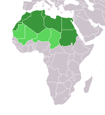
English: Map of countries in geo-political North Africa — as considered by the U.N.
- Credits
from en:Image:Africa-countries-northern.png

|
Free Software Foundation විසින් ප්රකාශිත GNU Free Documentation License බලපත්රයෙහි 1.2 හෝ ඊට අලුත් පිටපත්වල කොන්දේසිවලට යටත්ව මෙම ගොනුව පිටපත් කෙරුමට, නැවත බෙදාහාරුමට සහ/හෝ වෙනස් කෙරුමට අවසර දී ඇත; ඒ වෙනස් අංශ නොමැතිව, මුල් පිටු පෙළ නොමැතිව, පසු පිටු පෙළ නොමැතිවය. බලපත්රයේ පිටපතක් GNU Free Documentation License නම් අංශයේ දැක්වේ. |
| මෙම ගොනුව ක්රියේටිව් කොමන්ස් Attribution-Share Alike 3.0 Unported වරපත යටතේ අවසර ලබා ඇත. | ||
| ||
| GFDL බලපත්ර යාවත්කාල කෙරුමහි කොටසක් ලෙස මෙම ගොනුවට බලපත්ර ටැගය එක් කෙරිනි. |
ගොනු ඉතිහාසය
එම අවස්ථාවෙහිදී ගොනුව පැවැති ආකාරය නැරඹීමට දිනය/වේලාව මත ක්ලික් කරන්න.
| දිනය/වේලාව | කුඩා-රූපය | මාන | පරිශීලක | පරිකථනය | |
|---|---|---|---|---|---|
| වත්මන් | 15:22, 17 මාර්තු 2018 | | 360 × 392 (10 කි.බ.) | Maphobbyist | Montenegro border |
| 21:00, 31 මාර්තු 2016 |  | 360 × 392 (10 කි.බ.) | Fry1989 | Reverted to version as of 16:12, 13 January 2014 (UTC) | |
| 09:37, 7 නොවැම්බර් 2015 |  | 360 × 392 (10 කි.බ.) | Hpyounes | correction | |
| 16:12, 13 ජනවාරි 2014 |  | 360 × 392 (10 කි.බ.) | VVVF | See http://unstats.un.org/unsd/methods/m49/m49regin.htm | |
| 15:59, 13 ජනවාරි 2014 |  | 360 × 392 (13 කි.බ.) | VVVF | Reverted to version as of 20:15, 9 July 2011. See http://unstats.un.org/unsd/methods/m49/m49regin.htm | |
| 12:47, 20 ජූලි 2011 |  | 360 × 392 (7 කි.බ.) | Kahusi | See http://unstats.un.org/unsd/methods/m49/m49regin.htm | |
| 20:15, 9 ජූලි 2011 |  | 360 × 392 (13 කි.බ.) | Maphobbyist | South Sudan has become independent on July 9, 2011. Sudan and South Sudan are shown with the new international border between them. | |
| 11:13, 5 මැයි 2006 |  | 360 × 392 (4 කි.බ.) | Hautala | optimized with png | |
| 16:30, 20 අප්රේල් 2005 |  | 360 × 392 (14 කි.බ.) | Yonghokim | map of countries in Northern Africa. from en:Image:Africa-countries-northern.png {{GFDL}} |
ගොනු භාවිතය
මෙම ගොනුව භාවිතා කරන නිසිදු පිටුවක් නොමැත.
ගෝලීය ගොනු භාවිතය
පහත දැක්වෙන අනෙකුත් විකියන් මගින් මෙම ගොනුව භාවිතා කරයි:
- ce.wikipedia.org හි භාවිතය
- es.wikipedia.org හි භාවිතය
- fr.wikipedia.org හි භාවිතය
- he.wikipedia.org හි භාවිතය
- ru.wikipedia.org හි භාවිතය
- sc.wikipedia.org හි භාවිතය
- sv.wikinews.org හි භාවිතය