
ගොනුව:Adams Bridge aerial.jpg
මෙම පෙරදසුනෙහි විශාලත්වය: 450 × 600 පික්සල. අනෙකුත් විභේදනයන්: 180 × 240 පික්සල | 360 × 480 පික්සල | 576 × 768 පික්සල | 1,200 × 1,600 පික්සල.
මුල් ගොනුව (1,200 × 1,600 පික්සල, ගොනු විශාලත්වය: 410 කි.බ., MIME ශෛලිය: image/jpeg)
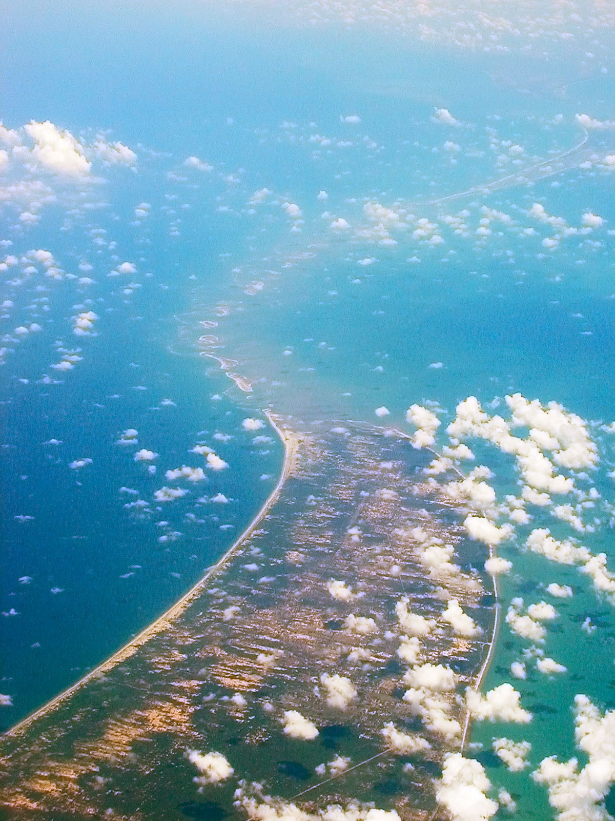
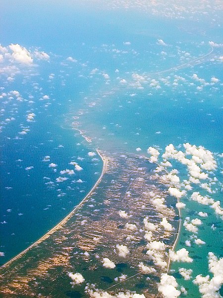
| විස්තරය | Aerial view of w:Ram Setu, taken while flying over Sri Lanka looking west. | ||
| දිනය | 28 April 05 | ||
| මූලාශ්රය | ස්වයං නිර්මාණයකි | ||
| කර්තෘ |
|
||
| අවසරය (මෙම ගොනුව නැවත භාවිතා කරමින්) |
මෙම කෘතියෙහි හිමිකම් අයිතීන් දරන්නා වන මම,පහත වරපත යටතේ එය ප්රකාශයට පත් කරමි: මෙම ගොනුව නිර්මාණශීලී පොදුවූවන් Attribution-Share Alike 2.5 Generic බලපත්රය යටතේ අවසර ලබා ඇත.
|
| Camera location | | View this and other nearby images on: OpenStreetMap |
|---|
ගොනු ඉතිහාසය
එම අවස්ථාවෙහිදී ගොනුව පැවැති ආකාරය නැරඹීමට දිනය/වේලාව මත ක්ලික් කරන්න.
| දිනය/වේලාව | කුඩා-රූපය | මාන | පරිශීලක | පරිකථනය | |
|---|---|---|---|---|---|
| වත්මන් | 10:40, 28 අප්රේල් 2007 | | 1,200 × 1,600 (410 කි.බ.) | Planemad | {{Information |Description=Aerial view of w:Adam's Bridge, taken while flying over Sri Lanka looking west. |Source=own work |Date= 28 April 05 |Author= w:user:PlaneMad |Permission={{self|cc-by-sa-2.5}} |other_versions= }} [[Category:Aerial photog |
ගොනු භාවිතය
පහත දැක්වෙන පිටුව විසින් මෙම ගොනුව භාවිතා කෙරෙයි:
ගෝලීය ගොනු භාවිතය
පහත දැක්වෙන අනෙකුත් විකියන් මගින් මෙම ගොනුව භාවිතා කරයි:
- ar.wikipedia.org හි භාවිතය
- ast.wikipedia.org හි භාවිතය
- as.wikipedia.org හි භාවිතය
- az.wikipedia.org හි භාවිතය
- ban.wikipedia.org හි භාවිතය
- be.wikipedia.org හි භාවිතය
- bg.wikipedia.org හි භාවිතය
- bn.wikipedia.org හි භාවිතය
- br.wikipedia.org හි භාවිතය
- ca.wikipedia.org හි භාවිතය
- cs.wikipedia.org හි භාවිතය
- de.wikipedia.org හි භාවිතය
- de.wikivoyage.org හි භාවිතය
- el.wikipedia.org හි භාවිතය
- en.wikipedia.org හි භාවිතය
- en.wikiquote.org හි භාවිතය
- en.wikivoyage.org හි භාවිතය
- en.wiktionary.org හි භාවිතය
- eo.wikipedia.org හි භාවිතය
- es.wikipedia.org හි භාවිතය
- eu.wikipedia.org හි භාවිතය
- fa.wikipedia.org හි භාවිතය
- fi.wikipedia.org හි භාවිතය
- gom.wikipedia.org හි භාවිතය
- gu.wikipedia.org හි භාවිතය
- he.wikipedia.org හි භාවිතය
- hi.wikipedia.org හි භාවිතය
- hu.wikipedia.org හි භාවිතය
- hy.wikipedia.org හි භාවිතය
- id.wikipedia.org හි භාවිතය
- incubator.wikimedia.org හි භාවිතය
- io.wikipedia.org හි භාවිතය
මෙම ගොනුවේ තවත් ගෝලීය භාවිත බලන්න.