
ගොනුව:Galapagos Islands topographic map-fr.png

මෙම පෙරදසුනෙහි විශාලත්වය: 600 × 600 පික්සල. අනෙකුත් විභේදනයන්: 240 × 240 පික්සල | 480 × 480 පික්සල | 768 × 768 පික්සල | 1,024 × 1,024 පික්සල | 2,160 × 2,160 පික්සල.
මුල් ගොනුව (2,160 × 2,160 පික්සල, ගොනු විශාලත්වය: 2.14 මෙ.බ., MIME ශෛලිය: image/png)
සාරාංශය
| Camera location | | View this and other nearby images on: OpenStreetMap |
|---|
| විස්තරය |
|
||
| දිනය | |||
| මූලාශ්රය |
Own work
|
||
| කර්තෘ | Eric Gaba (Sting - fr:Sting) | ||
| අවසරය (මෙම ගොනුව නැවත භාවිතා කරමින්) |
|
||
| අනෙකුත් අනුවාදයන් |
[]
|

.png)


බලපත්රීකරණය
I, මෙම කාර්යයේ ප්රකාශන අයිතිය දරන්නා,පහත බලපත්රය යටතේ එය ප්රකාශයට පත් කරනු ලබයි:

|
Free Software Foundation විසින් ප්රකාශිත GNU Free Documentation License බලපත්රයෙහි 1.2 හෝ ඊට අලුත් පිටපත්වල කොන්දේසිවලට යටත්ව මෙම ගොනුව පිටපත් කෙරුමට, නැවත බෙදාහාරුමට සහ/හෝ වෙනස් කෙරුමට අවසර දී ඇත; ඒ වෙනස් අංශ නොමැතිව, මුල් පිටු පෙළ නොමැතිව, පසු පිටු පෙළ නොමැතිවය. බලපත්රයේ පිටපතක් GNU Free Documentation License නම් අංශයේ දැක්වේ. |
This file is licensed under the Creative Commons Attribution-Share Alike 4.0 International, 3.0 Unported, 2.5 Generic, 2.0 Generic and 1.0 Generic license.
- ඔබ නිදහස්:
- බෙදාහදා ගැනීමට – කාර්යය පිටපත් කිරීමට,බෙදා හැරීමට සහ සම්ප්රේෂණය කිරීමට
- නැවත සංකලනය කිරීමට – කාර්යයට අනුවර්තනය වීමට
- පහත කොන්දේසිවලට යටත්ව:
- attribution – වරපත වෙත බැඳියක්ද සපයමින් ඔබ විසින් සුදුසු කර්තෘභාරය ප්රදානය කල යුතු අතර, කිසියම් වෙනස්වීම් සිදුකලේ නම් එයද සඳහන් කල යුතු වෙයි. ඕනෑම සුදුසු ආකාරයට මෙය ඔබ විසින් සිදුකල හැකි මුත්, වරපත්දායකයා විසින් ඔබ හෝ ඔබගේ භාවිතය හෝ පිටසන් කරන බවට ඇඟවෙන ලෙසින් එය සිදු නොකල යුතු වෙයි.
- share alike – මෙම විෂය කාරණා භාවිතා කොට නැවත සංකලනය, ප්රතියෝජනය හෝ වැඩිදියුණුව කලේ නම්, ඉන්පසු ඔබගේ දායකත්වය ඔබ විසින් බෙදාහැරිය යුත්තේ මුල් වරපත හා සමාන හෝ සංගතික හෝ වරපතක් භාවිතා කරමිනි.
ඔබට අභිමත වරපත තෝරාගත හැක.
ගොනු ඉතිහාසය
එම අවස්ථාවෙහිදී ගොනුව පැවැති ආකාරය නැරඹීමට දිනය/වේලාව මත ක්ලික් කරන්න.
| දිනය/වේලාව | කුඩා-රූපය | මාන | පරිශීලක | පරිකථනය | |
|---|---|---|---|---|---|
| වත්මන් | 00:34, 20 ජූලි 2010 | | 2,160 × 2,160 (2.14 මෙ.බ.) | Sting | Reverted to version as of 14:35, 19 July 2010 : test ended |
| 00:28, 20 ජූලි 2010 |  | 2,160 × 2,160 (4.3 මෙ.බ.) | Sting | sRGB converted (just for test) | |
| 14:35, 19 ජූලි 2010 |  | 2,160 × 2,160 (2.14 මෙ.බ.) | Sting | Color profile | |
| 14:37, 17 නොවැම්බර් 2009 |  | 2,160 × 2,160 (2.14 මෙ.බ.) | Sting | Embedded sRGB profile | |
| 12:52, 3 නොවැම්බර් 2008 |  | 2,160 × 2,160 (2.06 මෙ.බ.) | Sting | Corrections | |
| 01:35, 5 ජූලි 2008 |  | 2,160 × 2,160 (2.06 මෙ.බ.) | Sting | Oups ! | |
| 01:19, 5 ජූලි 2008 |  | 2,160 × 2,160 (2.07 මෙ.බ.) | Sting | Several little improvements | |
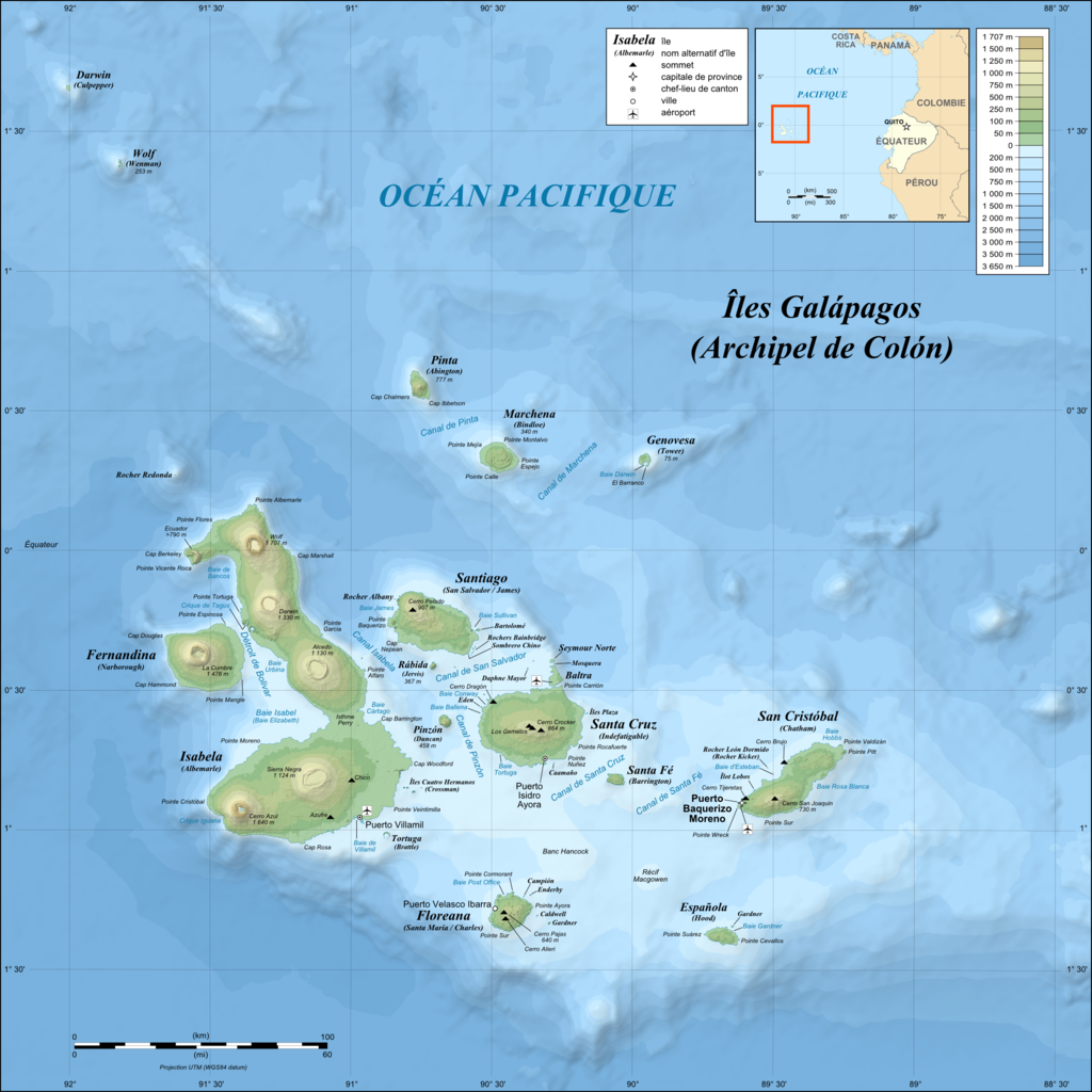
| 02:17, 3 ජූලි 2008 |  | 2,160 × 2,160 (1.87 මෙ.බ.) | Sting | == Summary == {{Location|00|30|00|S|90|30|00|W|scale:1000000}} <br/>{{Information |Description={{en|Topographic and bathymetric map of the Galápagos Islands, Ecuador.}} {{fr|Carte topographique et bathymétrique |
ගොනු භාවිතය
මෙම ගොනුව භාවිතා කරන නිසිදු පිටුවක් නොමැත.
ගෝලීය ගොනු භාවිතය
පහත දැක්වෙන අනෙකුත් විකියන් මගින් මෙම ගොනුව භාවිතා කරයි:
- en.wikipedia.org හි භාවිතය
- fr.wikipedia.org හි භාවිතය
- fr.wiktionary.org හි භාවිතය
- hu.wikipedia.org හි භාවිතය