
ගොනුව:Australia Perth location map.svg

Size of this PNG preview of this SVG file: 800 × 559 පික්සල. අනෙකුත් විභේදනයන්: 320 × 224 පික්සල | 640 × 447 පික්සල | 1,024 × 716 පික්සල | 1,280 × 895 පික්සල | 2,560 × 1,790 පික්සල | 1,250 × 874 පික්සල.
මුල් ගොනුව (SVG ගොනුව, නාමමාත්රිකව 1,250 × 874 පික්සල්, ගොනු විශාලත්වය: 130 කි.බ.)
සාරාංශය
| විස්තරය |
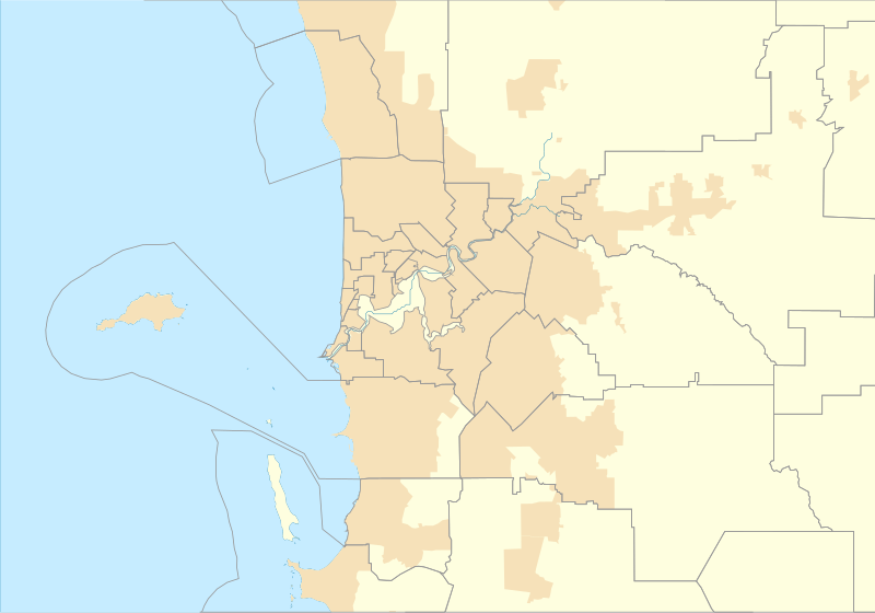
English: Location map of Perth in Western Australia |
| දිනය | |
| මූලාශ්රය | ස්වයං නිර්මාණයකි |
| කර්තෘ | Run to the hills, cos the end of the world is soon! |
බලපත්රීකරණය
මෙම කෘතියෙහි හිමිකම් අයිතීන් දරන්නා වන මම,පහත වරපත යටතේ එය ප්රකාශයට පත් කරමි:
This file is licensed under the Creative Commons Attribution-Share Alike 4.0 International license.
- ඔබ නිදහස්:
- බෙදාහදා ගැනීමට – කාර්යය පිටපත් කිරීමට,බෙදා හැරීමට සහ සම්ප්රේෂණය කිරීමට
- නැවත සංකලනය කිරීමට – කාර්යයට අනුවර්තනය වීමට
- පහත කොන්දේසිවලට යටත්ව:
- attribution – වරපත වෙත බැඳියක්ද සපයමින් ඔබ විසින් සුදුසු කර්තෘභාරය ප්රදානය කල යුතු අතර, කිසියම් වෙනස්වීම් සිදුකලේ නම් එයද සඳහන් කල යුතු වෙයි. ඕනෑම සුදුසු ආකාරයට මෙය ඔබ විසින් සිදුකල හැකි මුත්, වරපත්දායකයා විසින් ඔබ හෝ ඔබගේ භාවිතය හෝ පිටසන් කරන බවට ඇඟවෙන ලෙසින් එය සිදු නොකල යුතු වෙයි.
- share alike – මෙම විෂය කාරණා භාවිතා කොට නැවත සංකලනය, ප්රතියෝජනය හෝ වැඩිදියුණුව කලේ නම්, ඉන්පසු ඔබගේ දායකත්වය ඔබ විසින් බෙදාහැරිය යුත්තේ මුල් වරපත හා සමාන හෝ සංගතික හෝ වරපතක් භාවිතා කරමිනි.
ගොනු ඉතිහාසය
එම අවස්ථාවෙහිදී ගොනුව පැවැති ආකාරය නැරඹීමට දිනය/වේලාව මත ක්ලික් කරන්න.
| දිනය/වේලාව | කුඩා-රූපය | මාන | පරිශීලක | පරිකථනය | |
|---|---|---|---|---|---|
| වත්මන් | 00:43, 17 සැප්තැම්බර් 2016 | | 1,250 × 874 (130 කි.බ.) | Run to the hills, cos the end of the world is soon! | User created page with UploadWizard |
ගොනු භාවිතය
පහත දැක්වෙන පිටු 2 ක් විසින් මෙම ගොනුව භාවිතා කෙරෙයි:
ගෝලීය ගොනු භාවිතය
පහත දැක්වෙන අනෙකුත් විකියන් මගින් මෙම ගොනුව භාවිතා කරයි:
- en.wikipedia.org හි භාවිතය
- Fremantle
- Cape Peron
- Jualbup Lake
- Mount Eliza (Western Australia)
- Solidarity Park
- Barracks Arch
- Lake Monger
- Herdsman Lake
- Old Jarrah Tree
- Cottesloe Beach
- Forrestdale Lake
- Booragoon Lake
- Albany Bell Castle
- Beatty Park
- Bishop's House, Perth
- Perth Hebrew Congregation
- Thomsons Lake
- Castledare Boys' Home
- Public Transport Centre
- 2014 Perth Hills bushfire
- Module:Location map/data/Australia Perth
- User:Run to the hills, cos the end of the world is soon!/sandbox
- Module:Location map/data/Australia Perth/doc
- Shalom House
- Mundaring Weir Hotel
- Mahogany Inn
- Bassendean Fire Station
- Woodloes Homestead
- Newmarket Hotel
- Challenger Battery
- North Lake (Western Australia)
- Bibra Lake (Western Australia)
- 2021 Beechina bushfire
- User:Garzo/New Sandbox
- fr.wikipedia.org හි භාවිතය
මෙම ගොනුවේ තවත් ගෝලීය භාවිත බලන්න.